FAA INFORMATION EFFECTIVE 22 JANUARY 2026
Location
| FAA Identifier: | GLY |
| Lat/Long: | 38-21-16.9210N 093-40-45.0730W
38-21.282017N 093-40.751217W
38.3547003,-93.6791869
(estimated) |
| Elevation: | 822.5 ft. / 250.7 m (surveyed) |
| Variation: | 01E (2015) |
| From city: | 4 miles E of CLINTON, MO |
| Time zone: | UTC -6 (UTC -5 during Daylight Saving Time) |
| Zip code: | 64735 |
Airport Operations
| Airport use: | Open to the public |
| Control tower: | no |
| ARTCC: | KANSAS CITY CENTER |
| FSS: | COLUMBIA FLIGHT SERVICE STATION |
| NOTAMs facility: | GLY (NOTAM-D service available) |
| Attendance: | MON-FRI 0800-1700 |
| Wind indicator: | lighted |
| Segmented circle: | yes |
| Lights: | MIRL RWY 04/22 AND RWY 18/36 OPER DUSK-2200. AFTER 2200 ACTVT MIRL RWY 04/22 AND RWY 18/36 - CTAF. ACTVT REIL RWYS 04, 18, 22 & 36; PAPI RWYS 04, 18, 22 & 36 - CTAF. |
| Beacon: | white-green (lighted land airport)
Operates sunset to sunrise. |
Airport Communications
| CTAF/UNICOM: | 122.8 |
| WX AWOS-3PT: | 120.475 (660-885-3851) |
| WHITEMAN APPROACH: | 127.45 |
| WHITEMAN DEPARTURE: | 125.925 |
| WX AWOS-3PT at RAW (16 nm E): | 118.325 (660-547-3761) |
- APCH/DEP SVC PRVDD BY KANSAS CITY ARTCC ON FREQS 135.575/323.15 (KNOB NOSTER RCAG) WHEN WHITEMAN APCH CTL CLSD.
Nearby radio navigation aids
| VOR radial/distance | | VOR name | | Freq | | Var |
|---|
| BUMr076/38.4 | | BUTLER VORTAC | | 115.90 | | 07E |
Airport Services
| Fuel available: | 100LL JET-A
100LL:FUEL AVBL 24 HRS. SINGLE POINT JET A AVBL. AFTER HRS CALL ARPT MANAGER, 660-885-8889 |
| Parking: | tiedowns |
| Airframe service: | MAJOR |
| Powerplant service: | MAJOR |
| Bulk oxygen: | NONE |
Runway Information
Runway 18/36
| Dimensions: | 5000 x 75 ft. / 1524 x 23 m |
| Surface: | concrete, in excellent condition |
| Weight bearing capacity: | | Single wheel: | 60.0 | | Double tandem: | 72.0 |
|
| Runway edge lights: | medium intensity |
| RUNWAY 18 | | RUNWAY 36 |
| Latitude: | 38-21.603867N | | 38-20.780533N |
| Longitude: | 093-40.495117W | | 093-40.528107W |
| Elevation: | 810.1 ft. | | 803.5 ft. |
| Traffic pattern: | left | | left |
| Runway heading: | 181 magnetic, 182 true | | 001 magnetic, 002 true |
| Markings: | nonprecision | | nonprecision |
| Visual slope indicator: | 4-light PAPI on left (3.00 degrees glide path) | | 4-light PAPI on left (3.00 degrees glide path) |
| Runway end identifier lights: | yes | | yes |
| Touchdown point: | yes, no lights | | yes, no lights |
Runway 4/22
| Dimensions: | 4001 x 60 ft. / 1220 x 18 m |
| Surface: | asphalt, in fair condition |
| Weight bearing capacity: | | Single wheel: | 12.5 | | Double wheel: | 16.0 |
|
| Runway edge lights: | medium intensity |
| RUNWAY 4 | | RUNWAY 22 |
| Latitude: | 38-21.160927N | | 38-21.627540N |
| Longitude: | 093-41.346287W | | 093-40.754972W |
| Elevation: | 819.2 ft. | | 822.4 ft. |
| Traffic pattern: | left | | left |
| Runway heading: | 044 magnetic, 045 true | | 224 magnetic, 225 true |
| Markings: | nonprecision, in good condition | | nonprecision, in good condition |
| Visual slope indicator: | 4-light PAPI on left (3.50 degrees glide path) | | 4-light PAPI on left (3.50 degrees glide path) |
| Runway end identifier lights: | yes | | yes |
| Touchdown point: | yes, no lights | | yes, no lights |
| Obstructions: | 67 ft. trees, 1298 ft. from runway, 350 ft. right of centerline, 16:1 slope to clear | | none |
Airport Ownership and Management from official FAA records
| Ownership: | Publicly-owned |
| Owner: | CITY OF CLINTON
105 E. OHIO
CLINTON, MO 64735
Phone 660-885-6121 |
| Manager: | CLINTON AIRPORT ASSOCIATION, INC.
20 SE AIRPORT ROAD
CLINTON, MO 64735
Phone (660) 885-8889 |
Additional Remarks
| - | FOR CD IF UNA TO CTC ON FSS FREQ, CTC WHITEMAN APCH AT 660-687-3132. WHEN WHITEMAN APCH IS CLSD, CTC KANSAS CITY ARTCC AT 913-254-8508. |
Instrument Procedures
NOTE: All procedures below are presented as PDF files. If you need a reader for these files, you should download the free Adobe Reader.NOT FOR NAVIGATION. Please procure official charts for flight.
FAA instrument procedures published for use from 22 January 2026 at 0901Z to 19 February 2026 at 0900z.
IAPs - Instrument Approach Procedures |
|---|
| RNAV (GPS) RWY 04 | |
download (258KB) |
| RNAV (GPS) RWY 18 | |
download (250KB) |
| RNAV (GPS) RWY 22 | |
download (254KB) |
| RNAV (GPS) RWY 36 | |
download (278KB) |
| NOTE: Special Alternate Minimums apply | |
download (40KB) |
| NOTE: Special Take-Off Minimums/Departure Procedures apply | |
download (211KB) |
Other nearby airports with instrument procedures:
KRAW - Warsaw Municipal Airport (16 nm E)
KSZL - Whiteman Air Force Base (23 nm N)
KRCM - Skyhaven Airport (26 nm N)
KBUM - Butler Memorial Airport (31 nm W)
KDMO - Sedalia Regional Airport (32 nm NE)
|
|

Road maps at:
MapQuest
Bing
Google
| Aerial photo |
|---|
WARNING: Photo may not be current or correct
 Photo by Wallace White
Photo taken 04-May-2020
looking southeast.
Photo by Wallace White
Photo taken 04-May-2020
looking southeast.
Do you have a better or more recent aerial photo of Clinton Regional Airport that you would like to share? If so, please send us your photo.
|
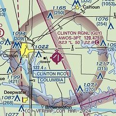
| Sectional chart |
|---|
|
| Airport distance calculator |
|---|
|
|
| Sunrise and sunset |
|---|
|
Times for 12-Feb-2026
| | Local
(UTC-6) | | Zulu
(UTC) |
|---|
| Morning civil twilight | | 06:43 | | 12:43 |
| Sunrise | | 07:10 | | 13:10 |
| Sunset | | 17:48 | | 23:48 |
| Evening civil twilight | | 18:16 | | 00:16 |
|
| Current date and time |
|---|
| Zulu (UTC) | 13-Feb-2026 04:48:09 |
|---|
| Local (UTC-6) | 12-Feb-2026 22:48:09 |
|---|
|
| METAR |
|---|
| KGLY | 130435Z AUTO 14004KT 10SM FEW045 03/M03 A3012 RMK AO2
|
KRAW
16nm E | 130435Z AUTO 15004KT 10SM CLR 06/M04 A3013 RMK AO2 T00591045
|
|
| TAF |
|---|
KSZL
23nm N | 121100Z 1211/1317 18012KT 9999 FEW250 QNH3010INS TX14/1221Z TNM01/1212Z
|
|
| NOTAMs |
|---|
NOTAMs are issued by the DoD/FAA and will open in a separate window not controlled by AirNav.
|
|

