FAA INFORMATION EFFECTIVE 25 DECEMBER 2025
Location
| FAA Identifier: | H34 |
| Lat/Long: | 36-04-41.6160N 093-45-17.1170W
36-04.693600N 093-45.285283W
36.0782267,-93.7547547
(estimated) |
| Elevation: | 1747.9 ft. / 532.8 m (surveyed) |
| Variation: | 01E (2015) |
| From city: | 2 miles SW of HUNTSVILLE, AR |
| Time zone: | UTC -6 (UTC -5 during Daylight Saving Time) |
| Zip code: | 72740 |
Airport Operations
| Airport use: | Open to the public |
| Activation date: | 07/1986 |
| Control tower: | no |
| ARTCC: | MEMPHIS CENTER |
| FSS: | JONESBORO FLIGHT SERVICE STATION |
| NOTAMs facility: | JBR (NOTAM-D service available) |
| Attendance: | UNATNDD |
| Wind indicator: | lighted |
| Segmented circle: | no |
| Lights: | ACTVT MIRL RY 12/30 - CTAF. |
| Beacon: | white-green (lighted land airport)
Operates sunset to sunrise. |
Airport Communications
| CTAF/UNICOM: | 122.8 |
| RAZORBACK APPROACH: | 126.6 [0530-2300] |
| RAZORBACK DEPARTURE: | 126.6 [0530-2300] |
| WX AWOS-3 at ASG (19 nm W): | 124.675 (479-750-2967) |
- APCH/DEP SVC PRVDD BY MEMPHIS ARTCC ON FREQS 126.1/269.0 (FAYETTEVILLE RCAG) WHEN RAZORBACK APCH CTL CLSD.
Nearby radio navigation aids
| VOR radial/distance | | VOR name | | Freq | | Var |
|---|
| RZCr116/20.4 | | RAZORBACK VORTAC | | 116.40 | | 04E |
| HROr237/29.9 | | HARRISON VOR/DME | | 112.50 | | 04E |
| NDB name | | Hdg/Dist | | Freq | | Var | | ID |
|---|
| SILOAM SPRINGS | | 097/36.2 | | 284 | | 04E | | SLG | ... .-.. --. |
Airport Services
| Fuel available: | 100LL
100LL:SELF SERVICE FUEL AVBL 24 HRS WITH CREDIT CARD. |
| Parking: | tiedowns |
Runway Information
Runway 12/30
| Dimensions: | 3601 x 60 ft. / 1098 x 18 m |
| Surface: | asphalt, in fair condition |
| Weight bearing capacity: | |
| Runway edge lights: | medium intensity |
| RUNWAY 12 | | RUNWAY 30 |
| Latitude: | 36-04.851988N | | 36-04.514875N |
| Longitude: | 093-45.602728W | | 093-45.001023W |
| Elevation: | 1743.6 ft. | | 1744.9 ft. |
| Traffic pattern: | left | | left |
| Runway heading: | 124 magnetic, 125 true | | 304 magnetic, 305 true |
| Markings: | nonprecision, in good condition | | nonprecision, in poor condition |
| Touchdown point: | yes, no lights | | yes, no lights |
Runway 3/21
| Dimensions: | 1250 x 60 ft. / 381 x 18 m |
| Surface: | turf, in fair condition
STEEP DROP OFF AT RY ENDS. |
| RUNWAY 3 | | RUNWAY 21 |
| Latitude: | 36-04.641333N | | 36-04.804500N |
| Longitude: | 093-45.314833W | | 093-45.160167W |
| Elevation: | 1739.0 ft. | | 1738.0 ft. |
| Traffic pattern: | left | | left |
| Runway heading: | 037 magnetic, 038 true | | 217 magnetic, 218 true |
| Markings: | NSTD, in fair condition | | NSTD, in fair condition |
| Touchdown point: | yes, no lights | | yes, no lights |
Airport Ownership and Management from official FAA records
| Ownership: | Publicly-owned |
| Owner: | CITY OF HUNTSVILLE
PO BOX 844
HUNTSVILLE, AR 72740
Phone 479-738-6607 |
| Manager: | CHARLES COGER
PO BOX 844
HUNTSVILLE, AR 72740
Phone 479-738-7287 |
Additional Remarks
| - | ULTRALIGHT ACTIVITY ON & INVOF ARPT. |
| - | FOR CD CTC RAZORBACK APCH 479-649-2416, WHEN APCH CLSD CTC MEMPHIS ARTCC AT 901-368-8453/8449. |
Instrument Procedures
NOTE: All procedures below are presented as PDF files. If you need a reader for these files, you should download the free Adobe Reader.NOT FOR NAVIGATION. Please procure official charts for flight.
FAA instrument procedures published for use from 25 December 2025 at 0901z to 22 January 2026 at 0900z.
IAPs - Instrument Approach Procedures |
|---|
| RNAV (GPS) RWY 12 | |
download (217KB) |
| RNAV (GPS) RWY 30 | |
download (213KB) |
| NOTE: Special Take-Off Minimums/Departure Procedures apply | |
download (388KB) |
Other nearby airports with instrument procedures:
KASG - Springdale Municipal Airport (19 nm W)
4M1 - Carroll County Airport (19 nm N)
KFYV - Drake Field Airport (21 nm W)
KROG - Rogers Executive Airport - Carter Field (25 nm NW)
KVBT - Bentonville Municipal Airport/Louise M Thaden Field (28 nm NW)
|
|

Road maps at:
MapQuest
Bing
Google
| Aerial photo |
|---|
WARNING: Photo may not be current or correct
 Photo courtesy of the Arkansas Department of Aeronautics
Taken in the Spring of 2007
Photo courtesy of the Arkansas Department of Aeronautics
Taken in the Spring of 2007
Do you have a better or more recent aerial photo of Huntsville Municipal Airport that you would like to share? If so, please send us your photo.
|
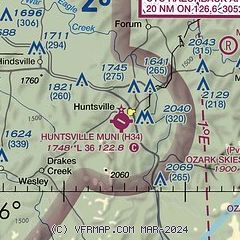
| Sectional chart |
|---|
|
| Airport distance calculator |
|---|
|
|
| Sunrise and sunset |
|---|
|
Times for 08-Jan-2026
| | Local
(UTC-6) | | Zulu
(UTC) |
|---|
| Morning civil twilight | | 06:59 | | 12:59 |
| Sunrise | | 07:27 | | 13:27 |
| Sunset | | 17:16 | | 23:16 |
| Evening civil twilight | | 17:45 | | 23:45 |
|
| Current date and time |
|---|
| Zulu (UTC) | 08-Jan-2026 07:38:29 |
|---|
| Local (UTC-6) | 08-Jan-2026 01:38:29 |
|---|
|
| METAR |
|---|
KASG
18nm W | 080248Z 12005KT 10SM CLR 13/08 A2984
|
KFYV
20nm W | 080653Z AUTO 00000KT 10SM BKN120 17/08 A2980 RMK AO2 SLP081 T01670078
|
KROG
24nm NW | 080658Z AUTO 15009KT 10SM FEW120 15/06 A2979 RMK AO2 SLP080 T01500061 TSNO
|
KVBT
28nm NW | 080656Z AUTO 15008KT 10SM FEW120 14/07 A2979 RMK AO2 SLP085 T01390067 $
|
KXNA
29nm NW | 080653Z AUTO 16009KT 10SM CLR 14/06 A2978 RMK AO2 SLP076 T01390061
|
KHRO
31nm E | 080653Z AUTO 14010KT 10SM CLR 14/06 A2983 RMK AO2 SLP092 T01440061
|
KSLG
35nm W | 080656Z AUTO 16009KT 10SM CLR 16/07 A2977 RMK AO2 SLP075 T01560072
|
|
| TAF |
|---|
KFYV
20nm W | 080520Z 0806/0906 16007KT P6SM SCT100 BKN250 FM080800 18010KT P6SM VCSH BKN040 OVC100 WS020/19040KT FM081500 18017G29KT 6SM -SHRA BR OVC020 TEMPO 0816/0819 4SM TSRA BR OVC010CB FM082000 24010G20KT P6SM SCT050 BKN150 FM090200 32010G20KT P6SM FEW030
|
KROG
24nm NW | 080520Z 0806/0906 16007KT P6SM SCT100 BKN250 FM080800 18010KT P6SM VCSH BKN040 OVC100 WS020/19040KT FM081500 18017G29KT 6SM -SHRA BR OVC020 TEMPO 0816/0819 4SM TSRA BR OVC010CB FM082000 24010G20KT P6SM SCT050 BKN150 FM090200 32010G20KT P6SM FEW030
|
|
| NOTAMs |
|---|
NOTAMs are issued by the DoD/FAA and will open in a separate window not controlled by AirNav.
|
|


