FAA INFORMATION EFFECTIVE 11 JUNE 2026
Location
| FAA Identifier: | H68 |
| Lat/Long: | 35-57-56.5000N 095-20-30.5000W
35-57.941667N 095-20.508333W
35.9656944,-95.3418056
(estimated) |
| Elevation: | 598.9 ft. / 182.5 m (surveyed) |
| Variation: | 04E (2005) |
| From city: | 2 miles E of WAGONER, OK |
| Time zone: | UTC -5 (UTC -6 during Standard Time) |
| Zip code: | 74467 |
Airport Operations
| Airport use: | Open to the public |
| Activation date: | 12/1952 |
| Control tower: | no |
| ARTCC: | KANSAS CITY CENTER |
| FSS: | MC ALESTER FLIGHT SERVICE STATION |
| NOTAMs facility: | MLC (NOTAM-D service available) |
| Attendance: | UNATNDD |
| Wind indicator: | yes |
| Segmented circle: | yes |
| Lights: | PAPI RWY 18 & 36 OPER CONSLY; MIRL RWY 18/36 ON DUSK-DAWN. |
| Beacon: | white-green (lighted land airport)
Operates sunset to sunrise. |
Airport Communications
| CTAF: | 122.9 |
| TULSA APPROACH: | 119.1 |
| TULSA DEPARTURE: | 119.1 |
| WX AWOS-3PT at H71 (16 nm N): | 120.1 (918-476-0517) |
| WX AWOS-3P at TQH (17 nm E): | 118.425 (918-453-2729) |
| WX ASOS at MKO (19 nm S): | 135.025 (918-683-6987) |
Nearby radio navigation aids
| VOR radial/distance | | VOR name | | Freq | | Var |
|---|
| TULr115/25.7 | | TULSA VORTAC | | 114.40 | | 08E |
| OKMr049/30.3 | | OKMULGEE VOR/DME | | 114.90 | | 08E |
Airport Services
| Parking: | tiedowns |
| Airframe service: | MAJOR |
| Powerplant service: | MAJOR |
| Bottled oxygen: | NONE |
| Bulk oxygen: | NONE |
Runway Information
Runway 18/36
| Dimensions: | 3401 x 60 ft. / 1037 x 18 m |
| Surface: | asphalt, in fair condition |
| Weight bearing capacity: | |
| Runway edge lights: | medium intensity |
| RUNWAY 18 | | RUNWAY 36 |
| Latitude: | 35-58.221520N | | 35-57.661043N |
| Longitude: | 095-20.510493W | | 095-20.505978W |
| Elevation: | 583.7 ft. | | 598.9 ft. |
| Traffic pattern: | left | | left |
| Runway heading: | 176 magnetic, 180 true | | 356 magnetic, 360 true |
| Markings: | nonprecision, in good condition | | nonprecision, in good condition |
| Visual slope indicator: | 2-light PAPI on left (3.00 degrees glide path) | | 2-light PAPI on right (3.00 degrees glide path) |
| Touchdown point: | yes, no lights | | yes, no lights |
| Obstructions: | 41 ft. trees, 478 ft. from runway, 94 ft. left of centerline, 6:1 slope to clear
12 FT TREE 9 FT FM RWY 18 END 69 FT LEFT OF CNTRLN. | | 37 ft. tree, 536 ft. from runway, 262 ft. right of centerline, 9:1 slope to clear |
Airport Ownership and Management from official FAA records
| Ownership: | Publicly-owned |
| Owner: | CITY OF WAGONER
PO BOX 406, 231 CHURCH ST.
WAGONER, OK 74467
Phone 918-485-2554 |
| Manager: | WHITLEY CROW
231 CHURCH ST., 231 CHURCH ST.
WAGONER, OK 74467
Phone 918-485-2554
AFT HRS CTC 918-527-7099 OR 918-869-6150. |
Additional Remarks
| - | ULTRALIGHTS ON & INVOF ARPT. |
| - | FOR CD CTC MEMPHIS ARTCC AT 901-368-8453/8449. |
| - | BIRDS AND DEER REPRTD ON AND INVOF ARPT. |
Instrument Procedures
NOTE: All procedures below are presented as PDF files. If you need a reader for these files, you should download the free Adobe Reader.NOT FOR NAVIGATION. Please procure official charts for flight.
FAA instrument procedures published for use from 11 June 2026 at 0901Z to 09 July 2026 at 0900z.
IAPs - Instrument Approach Procedures |
|---|
| RNAV (GPS) RWY 18 | |
download (183KB) |
| RNAV (GPS) RWY 36 | |
download (241KB) |
| NOTE: Special Take-Off Minimums/Departure Procedures apply | |
download (131KB) |
Other nearby airports with instrument procedures:
H71 - Mid-America Industrial Airport (16 nm N)
KTQH - Tahlequah Municipal Airport (17 nm E)
KMKO - Muskogee-Davis Regional Airport (19 nm S)
KGCM - Claremore Regional Airport (21 nm N)
KTUL - Tulsa International Airport (30 nm NW)
|
|

Road maps at:
MapQuest
Bing
Google
| Aerial photo |
|---|
WARNING: Photo may not be current or correct
 Photo by Brent Butler
Photo taken 17-Aug-2010
Sam landing at Wagoner
Photo by Brent Butler
Photo taken 17-Aug-2010
Sam landing at Wagoner
Do you have a better or more recent aerial photo of Hefner-Easley Airport that you would like to share? If so, please send us your photo.
|
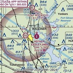
| Sectional chart |
|---|
|
| Airport distance calculator |
|---|
|
|
| Sunrise and sunset |
|---|
|
Times for 07-Jul-2026
| | Local
(UTC-5) | | Zulu
(UTC) |
|---|
| Morning civil twilight | | 05:42 | | 10:42 |
| Sunrise | | 06:12 | | 11:12 |
| Sunset | | 20:40 | | 01:40 |
| Evening civil twilight | | 21:10 | | 02:10 |
|
| Current date and time |
|---|
| Zulu (UTC) | 08-Jul-2026 00:54:21 |
|---|
| Local (UTC-5) | 07-Jul-2026 19:54:21 |
|---|
|
| METAR |
|---|
KH71
16nm N | 080035Z AUTO 06003KT 10SM CLR 31/21 A3001 RMK AO2 TSNO
|
KGCM
21nm N | 080035Z AUTO 00000KT 10SM CLR A3001 RMK AO2
|
KTUL
30nm NW | 072353Z 09007KT 10SM FEW055 32/19 A3002 RMK AO2 SLP156 T03220194 10344 20311 56008
|
|
| TAF |
|---|
KTUL
30nm NW | 071720Z 0718/0818 15006KT P6SM SCT040 SCT250
|
KRVS
32nm W | 071720Z 0718/0818 VRB05KT P6SM SCT040 SCT250
|
|
| NOTAMs |
|---|
NOTAMs are issued by the DoD/FAA and will open in a separate window not controlled by AirNav.
|
|

