FAA INFORMATION EFFECTIVE 11 JUNE 2026
Location
| FAA Identifier: | JYL |
| Lat/Long: | 32-38-43.8820N 081-35-47.8020W
32-38.731367N 081-35.796700W
32.6455228,-81.5966117
(estimated) |
| Elevation: | 190.3 ft. / 58.0 m (surveyed) |
| Variation: | 07W (2020) |
| From city: | 7 miles S of SYLVANIA, GA |
| Time zone: | UTC -4 (UTC -5 during Standard Time) |
| Zip code: | 30467 |
Airport Operations
| Airport use: | Open to the public |
| Activation date: | 05/1943 |
| Control tower: | no |
| ARTCC: | JACKSONVILLE CENTER |
| FSS: | MACON FLIGHT SERVICE STATION |
| NOTAMs facility: | MCN (NOTAM-D service available) |
| Attendance: | 0800-1700 |
| Wind indicator: | lighted |
| Segmented circle: | yes |
| Lights: | MIRL RWY 05/23 PRESET LOW INTST DUSK-0100, TO INCR INTST AND ACTVT AFTER 0100 - CTAF. PAPI RWY 05 & 23 - CTAF. |
| Beacon: | white-green (lighted land airport)
Operates sunset to sunrise. |
Airport Communications
| CTAF/UNICOM: | 122.8 |
| WX AWOS-3: | 118.875 (912-857-9000) |
| WX AWOS-3 at TBR (12 nm SW): | 119.025 (912-764-9321) |
- APCH/DEP SVC PRVDD BY JACKSONVILLE ARTCC ON FREQS 132.925/363.2 (MILLEN RCAG).
Nearby radio navigation aids
| VOR radial/distance | | VOR name | | Freq | | Var |
|---|
| ALDr216/(26.8) | | ALLENDALE VOR | | 116.70 | | 01W |
| SAVr332/36.1 | | SAVANNAH VORTAC | | 115.95 | | 06W |
| NDB name | | Hdg/Dist | | Freq | | Var | | ID |
|---|
| BULLO | | 019/14.2 | | 407 | | 05W | | BZQ | -... --.. --.- |
Airport Services
| Fuel available: | 100LL JET-A+
100LL:FUEL 24 HR CREDIT CARD SVC AVBL. |
| Parking: | tiedowns |
| Airframe service: | MAJOR |
| Powerplant service: | MAJOR |
| Bottled oxygen: | NONE |
| Bulk oxygen: | NONE |
Runway Information
Runway 5/23
| Dimensions: | 5501 x 100 ft. / 1677 x 30 m |
| Surface: | asphalt, in fair condition |
| Weight bearing capacity: | |
| Runway edge lights: | medium intensity |
| RUNWAY 5 | | RUNWAY 23 |
| Latitude: | 32-38.398288N | | 32-39.011427N |
| Longitude: | 081-36.038068W | | 081-35.247753W |
| Elevation: | 169.5 ft. | | 190.3 ft. |
| Traffic pattern: | right | | left |
| Runway heading: | 054 magnetic, 047 true | | 234 magnetic, 227 true |
| Markings: | nonprecision, in good condition | | nonprecision, in good condition |
| Visual slope indicator: | 2-light PAPI on left (3.00 degrees glide path) | | 2-light PAPI on left (3.00 degrees glide path) |
| Touchdown point: | yes, no lights | | yes, no lights |
| Obstructions: | 30 ft. trees, 971 ft. from runway, 336 ft. left of centerline, 25:1 slope to clear | | 32 ft. trees, 908 ft. from runway, 467 ft. left of centerline, 22:1 slope to clear |
Runway 15/33
| Dimensions: | 3787 x 75 ft. / 1154 x 23 m |
| Surface: | asphalt, in good condition |
| RUNWAY 15 | | RUNWAY 33 |
| Latitude: | 32-39.027082N | | 32-38.512627N |
| Longitude: | 081-36.229308W | | 081-35.810880W |
| Elevation: | 175.3 ft. | | 174.9 ft. |
| Traffic pattern: | right | | left |
| Runway heading: | 152 magnetic, 145 true | | 332 magnetic, 325 true |
| Markings: | basic, in good condition | | basic, in good condition |
| Touchdown point: | yes, no lights | | yes, no lights |
| Obstructions: | 65 ft. trees, 1596 ft. from runway, 259 ft. left of centerline, 21:1 slope to clear | | none |
Airport Ownership and Management from official FAA records
| Ownership: | Publicly-owned |
| Owner: | SYLVANIA SCREVEN ARPT AUTH
104 EAST TELEPHONE STREET
SYLVANIA, GA 30467
Phone 912-8573328 |
| Manager: | HANK MAIERHOFFER
538 BEACON ROAD
SYLVANIA, GA 30467
Phone 912-857-3220
ALT PHONE 912-682-9313. |
Additional Remarks
| - | DEER ON & INVOF ARPT. |
| - | FOR CD CTC JACKSONVILLE ARTCC AT 904-845-1592. |
| - | MIL OPN RQR 24 HR PPR AT 912-687-0653. |
Instrument Procedures
NOTE: All procedures below are presented as PDF files. If you need a reader for these files, you should download the free Adobe Reader.NOT FOR NAVIGATION. Please procure official charts for flight.
FAA instrument procedures published for use from 11 June 2026 at 0901Z to 09 July 2026 at 0900z.
IAPs - Instrument Approach Procedures |
|---|
| RNAV (GPS) RWY 05 | |
download (234KB) |
| RNAV (GPS) RWY 23 | |
download (236KB) |
| NOTE: Special Alternate Minimums apply | |
download (153KB) |
| NOTE: Special Take-Off Minimums/Departure Procedures apply | |
download (594KB) |
Other nearby airports with instrument procedures:
KTBR - Statesboro-Bulloch County Airport (12 nm SW)
2J5 - Millen Airport (24 nm NW)
KAQX - Allendale County Airport (27 nm NE)
KMHP - John Edwin Jones Sr Field/Metter Municipal Airport (29 nm SW)
KCWV - Claxton-Evans County Airport (30 nm SW)
|
|

Road maps at:
MapQuest
Bing
Google
| Aerial photo |
|---|
WARNING: Photo may not be current or correct

Do you have a better or more recent aerial photo of Plantation Airpark that you would like to share? If so, please send us your photo.
|
| Sectional chart |
|---|
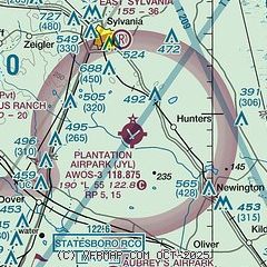
|
| Airport distance calculator |
|---|
|
|
| Sunrise and sunset |
|---|
|
Times for 30-Jun-2026
| | Local
(UTC-4) | | Zulu
(UTC) |
|---|
| Morning civil twilight | | 05:54 | | 09:54 |
| Sunrise | | 06:23 | | 10:23 |
| Sunset | | 20:37 | | 00:37 |
| Evening civil twilight | | 21:06 | | 01:06 |
|
| Current date and time |
|---|
| Zulu (UTC) | 30-Jun-2026 09:47:45 |
|---|
| Local (UTC-4) | 30-Jun-2026 05:47:45 |
|---|
|
| METAR |
|---|
| KJYL | 300935Z AUTO 00000KT 7SM CLR 22/22 A3007 RMK AO2 T02150215
|
KTBR
12nm SW | 300915Z AUTO 04001KT 10SM CLR 23/23 A3004 RMK AO2
|
|
| TAF |
|---|
KSAV
38nm SE | 300520Z 3006/0106 04003KT P6SM FEW030 BKN250 FM301400 06009KT P6SM SCT035 FM301900 11011G17KT P6SM SCT040 PROB30 3019/3022 5SM -TSRA BKN035CB FM010100 10005KT P6SM SCT050
|
KSVN
44nm SE | 300100Z 3001/0107 21006KT 9999 SCT150 QNH3001INS TEMPO 3006/3010 VRB06KT 4800 BR SCT005 BKN060 QNH3003INS BECMG 3012/3013 10006KT 9999 SCT010 BKN030 QNH3007INS BECMG 3015/3016 06012G18KT 9999 SCT040 QNH3008INS TX32/3017Z TN24/3009Z
|
KNBC
46nm E | 292000Z 2921/3021 VRB06KT 9999 SCT050 SCT100 QNH3000INS TEMPO 2921/2923 VRB06KT 9999 -TSRA BKN050CB BECMG 3004/3006 VRB06KT 9999 FEW050 QNH3002INS FM301500 VRB06KT 9999 VCTS BKN050CB QNH3003INS BECMG 3018/3020 VRB06KT 9999 NSW SKC QNH3003INS TX36/3018Z TN24/3010Z
|
|
| NOTAMs |
|---|
NOTAMs are issued by the DoD/FAA and will open in a separate window not controlled by AirNav.
|
|


