FAA INFORMATION EFFECTIVE 16 APRIL 2026
Location
| FAA Identifier: | K09 |
| Lat/Long: | 43-27-11.7540N 074-30-54.0290W
43-27.195900N 074-30.900483W
43.4532650,-74.5150081
(estimated) |
| Elevation: | 1703.2 ft. / 519.1 m (surveyed) |
| Variation: | 14W (2010) |
| From city: | 1 mile N of PISECO, NY |
| Time zone: | UTC -4 (UTC -5 during Standard Time) |
| Zip code: | 12139 |
Airport Operations
| Airport use: | Open to the public |
| Activation date: | 09/1945 |
| Control tower: | no |
| ARTCC: | BOSTON CENTER |
| FSS: | BUFFALO FLIGHT SERVICE STATION |
| NOTAMs facility: | BUF (NOTAM-D service available) |
| Attendance: | MAY-OCT SAT-SUN 0900-1700 |
| Wind indicator: | lighted |
| Segmented circle: | yes |
| Lights: | ACTVT REIL RWY 04 & 22; PAPI RWY 04; MIRL RWY 04/22; HELIPAD PERIMETER LGTS - CTAF. RWY LGTS (ELECTRIC EYE OVER-RIDE). |
Airport Communications
- APCH/DEP SVC PRVDD BY BOSTON ARTCC ON FREQS 135.25/377.1 (TURIN RCAG).
Nearby radio navigation aids
| NDB name | | Hdg/Dist | | Freq | | Var | | ID |
|---|
| JOHNSTOWN | | 358/28.4 | | 523 | | 14W | | JJH | .--- .--- .... |
Airport Services
| Fuel available: | 100LL |
| Parking: | hangars and tiedowns |
| Airframe service: | NONE |
| Powerplant service: | NONE |
| Bottled oxygen: | NONE |
| Bulk oxygen: | NONE |
Runway Information
Runway 4/22
| Dimensions: | 3016 x 60 ft. / 919 x 18 m |
| Surface: | asphalt, in good condition |
| Weight bearing capacity: | |
| Runway edge lights: | medium intensity |
| RUNWAY 4 | | RUNWAY 22 |
| Latitude: | 43-26.982460N | | 43-27.409348N |
| Longitude: | 074-31.074350W | | 074-30.726587W |
| Elevation: | 1694.0 ft. | | 1702.9 ft. |
| Traffic pattern: | right | | left |
| Runway heading: | 045 magnetic, 031 true | | 225 magnetic, 211 true |
| Markings: | nonprecision, in good condition | | basic, in good condition |
| Visual slope indicator: | 2-light PAPI on left (3.80 degrees glide path)
RWY 04 PAPI UNUSBL 9 DEG RIGHT OF CTRLN. | | |
| Runway end identifier lights: | yes | | yes |
| Touchdown point: | yes, no lights | | yes, no lights |
| Obstructions: | 52 ft. trees, 450 ft. from runway, 144 ft. right of centerline, 4:1 slope to clear
ROADS PARALLEL TO RWY 124 FT LT AND 215 FT RT. | | 92 ft. trees, 562 ft. from runway, 201 ft. right of centerline, 3:1 slope to clear
RWY 22 +80 FT TREES, 0-200 FT FROM RWY, 243 FT LT AND RT OF CENTERLINE. |
Helipad H1
| Dimensions: | 40 x 40 ft. / 12 x 12 m |
| Surface: | asphalt, in good condition |
| Runway edge lights: | PERI |
| Latitude: | 43-26.988333N | | |
| Longitude: | 074-31.013667W | | |
| Elevation: | 1694.0 ft. | | |
| Traffic pattern: | left | | left |
| Approach lights: | RLLS | | |
Airport Ownership and Management from official FAA records
| Ownership: | Publicly-owned |
| Owner: | TOWN OF ARIETTA
PO BOX 37
PISECO LAKE, NY 12139
Phone 518-548-3415 |
| Manager: | TOWN OF ARIETTA
BOX 37
PISECO LAKE, NY 12139
Phone 518-548-3415
AFT HRS CALL 518-571-6066. |
Additional Remarks
| - | CTN-MODERATE TURBULANCE IN APCH TO RWY 22. |
| - | FOR CD CTC SYRACUSE APCH AT 315-455-6218. |
| - | SEAGULLS - DEER - BEARS OCCASIONALLY VCNTY OF RWY DURING SUMMER MONTHS. |
| - | ACFT DEPARTING RWY 22 ARE REQUESTED TO MAINTAIN RWY HEADING UNTIL PAST ISLAND CHECKPOINT, PRIOR TO MAKING LEFT TURN. ACFT ARRIVING MAINTAIN RGT DOWNWIND HEADING UNTIL PAST ISLAND CHECKPOINT. |
| - | TWYS HAVE REFLECTIVE MARKERS. |
| - | EXPECT TURBULENCE & DOWNDRAFTS DURG PERIODS OF STRONG CROSSWINDS. |
| - | AREA NOT MAINTAINED FOR SKI EQUIPPED ACFT. |
| - | RWY 04/22 MAY BE UNUSBL DUE TO SNOW ACCUMULATION NOV-APR. CHECK NOTAMS OR CALL 518-548-3415 FOR AIRFIELD CONDITIONS. |
Instrument Procedures
NOTE: All procedures below are presented as PDF files. If you need a reader for these files, you should download the free Adobe Reader.NOT FOR NAVIGATION. Please procure official charts for flight.
FAA instrument procedures published for use from 16 April 2026 at 0901Z to 14 May 2026 at 0900Z.
IAPs - Instrument Approach Procedures |
|---|
| RNAV (GPS) RWY 04 | |
download (214KB) |
| NOTE: Special Take-Off Minimums/Departure Procedures apply | |
download (150KB) |
Other nearby airports with instrument procedures:
NY0 - Fulton County Airport (28 nm S)
5B2 - Saratoga County Airport (37 nm SE)
KGFL - Floyd Bennett Memorial Airport (40 nm E)
KRME - Griffiss International Airport (41 nm W)
KSCH - Schenectady County Airport (44 nm SE)
|
|

Road maps at:
MapQuest
Bing
Google
| Aerial photo |
|---|
WARNING: Photo may not be current or correct
 Photo by David Newcomer
Photo taken 07-Sep-2014
looking north.
Photo by David Newcomer
Photo taken 07-Sep-2014
looking north.
Do you have a better or more recent aerial photo of Piseco Airport that you would like to share? If so, please send us your photo.
|
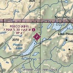
| Sectional chart |
|---|
|
| Airport distance calculator |
|---|
|
|
| Sunrise and sunset |
|---|
|
Times for 03-May-2026
| | Local
(UTC-4) | | Zulu
(UTC) |
|---|
| Morning civil twilight | | 05:18 | | 09:18 |
| Sunrise | | 05:49 | | 09:49 |
| Sunset | | 20:01 | | 00:01 |
| Evening civil twilight | | 20:32 | | 00:32 |
|
| Current date and time |
|---|
| Zulu (UTC) | 03-May-2026 23:10:10 |
|---|
| Local (UTC-4) | 03-May-2026 19:10:10 |
|---|
|
| METAR |
|---|
KNY0
28nm S | 032255Z AUTO 28008KT 10SM SCT070 10/M05 A2980 RMK AO2 T00971055
|
KGFL
40nm E | 032253Z AUTO 29009G19KT 10SM CLR 13/M09 A2976 RMK AO2 SLP080 T01281089
|
KRME
41nm W | 032253Z 28010G21KT 10SM BKN070 OVC085 12/M02 A2983 RMK AO2 SLP101 T01171017
|
KSCH
45nm SE | 032245Z 28014G20KT 10SM CLR 13/M07 A2979
|
|
| TAF |
|---|
KGFL
40nm E | 031731Z 0318/0418 32012G25KT P6SM OVC070 FM040000 28006KT P6SM FEW080 FM040400 22004KT P6SM FEW040 BKN090 WS020/27040KT PROB30 0404/0408 -SHRA BKN040 FM041400 22013G25KT P6SM FEW040 SCT070
|
KRME
41nm W | 031732Z 0318/0418 29013G20KT P6SM FEW080 FM040000 VRB04KT P6SM BKN050 PROB30 0402/0404 P6SM -RA OVC050 FM040600 19007KT P6SM OVC100 WS020/25035KT FM041200 22012G18KT P6SM BKN030
|
|
| NOTAMs |
|---|
NOTAMs are issued by the DoD/FAA and will open in a separate window not controlled by AirNav.
|
|

