FAA INFORMATION EFFECTIVE 01 OCTOBER 2026
Location
| FAA Identifier: | AFP |
| Lat/Long: | 35-01-14.2960N 080-04-37.6230W
35-01.238267N 080-04.627050W
35.0206378,-80.0771175
(estimated) |
| Elevation: | 299.7 ft. / 91.3 m (surveyed) |
| Variation: | 07W (2000) |
| From city: | 3 miles N of WADESBORO, NC |
| Time zone: | UTC -4 (UTC -5 during Standard Time) |
| Zip code: | 28170 |
Airport Operations
| Airport use: | Open to the public |
| Activation date: | 05/1941 |
| Control tower: | no |
| ARTCC: | ATLANTA CENTER |
| FSS: | RALEIGH FLIGHT SERVICE STATION |
| NOTAMs facility: | RDU (NOTAM-D service available) |
| Attendance: | MON-FRI 0830-1700
FOR AFT HRS SVC CALL 704-389-0633. |
| Wind indicator: | lighted |
| Segmented circle: | yes |
| Lights: | ACTVT DUSK TO DAWN, REIL RWY 16 & 34; PAPI RWY 16 & 34; MIRL RWY 16/34 - CTAF. |
| Beacon: | white-green (lighted land airport)
Operates sunset to sunrise. |
Airport Communications
| CTAF/UNICOM: | 122.8 |
| WX AWOS-3: | 119.325 (704-695-0623) |
| CHARLOTTE APPROACH: | 120.05 |
| CHARLOTTE DEPARTURE: | 120.05 |
| JOOLS STAR: | 135.6 |
| RASLN STAR: | 126.15 |
| WX AWOS-3 at RCZ (17 nm SE): | 118.775 (910-997-4093) |
| WX AWOS-3 at CQW (19 nm S): | 124.825 (843-537-3301) |
Nearby radio navigation aids
| VOR radial/distance | | VOR name | | Freq | | Var |
|---|
| CTFr027/24.3 | | CHESTERFIELD VOR/DME | | 114.55 | | 03W |
| SDZr247/26.7 | | SANDHILLS VORTAC | | 111.80 | | 03W |
| NDB name | | Hdg/Dist | | Freq | | Var | | ID |
|---|
| HARTSVILLE | | 010/36.9 | | 341 | | 07W | | HVS | .... ...- ... |
Airport Services
| Fuel available: | 100LL JET-A1+
100LL:100LL FUEL - 24 HR SELF SVC AVBL WITH CREDIT CARD.
A1+:FOR JET-A AFT HRS CALL FBO DURG OFC HRS FOR PRE-ARNGMT. |
| Parking: | tiedowns |
| Airframe service: | NONE |
| Powerplant service: | NONE |
| Bottled oxygen: | NONE |
| Bulk oxygen: | NONE |
Runway Information
Runway 16/34
| Dimensions: | 5498 x 100 ft. / 1676 x 30 m |
| Surface: | asphalt, in good condition |
| Weight bearing capacity: | | Single wheel: | 12.0 | | Double wheel: | 60.0 |
|
| Runway edge lights: | medium intensity |
| RUNWAY 16 | | RUNWAY 34 |
| Latitude: | 35-01.647418N | | 35-00.829108N |
| Longitude: | 080-04.863893W | | 080-04.390240W |
| Elevation: | 299.3 ft. | | 296.8 ft. |
| Traffic pattern: | left | | left |
| Runway heading: | 162 magnetic, 155 true | | 342 magnetic, 335 true |
| Markings: | nonprecision, in good condition | | precision, in good condition |
| Visual slope indicator: | 4-light PAPI on left (3.00 degrees glide path) | | 4-light PAPI on left (3.00 degrees glide path) |
| Runway end identifier lights: | yes | | yes |
| Touchdown point: | yes, no lights | | yes, no lights |
| Instrument approach: | | | ILS/DME |
| Obstructions: | 88 ft. trees, 1425 ft. from runway, 157 ft. right of centerline, 13:1 slope to clear
15 FT TREES 152 FT FROM END OF RWY AND OFFSET 72 FT LEFT OF CNTRLN AND 7 FT TREES 44 FT FROM END OF RWY AND OFFSET 194 FT LEFT. | | 50 ft. trees, 1103 ft. from runway, 195 ft. right of centerline, 18:1 slope to clear
17 FT HILL 200 FT FM EOR AND 364 FT LEFT OF CNTRLN. |
Airport Ownership and Management from official FAA records
| Ownership: | Publicly-owned |
| Owner: | ANSON COUNTY
101 S. GREENE STREET
WADESBORO, NC 28170
Phone 704-994-3200 |
| Manager: | REX EDWARDS
2980 AIRPORT ROAD
WADESBORO, NC 28170
Phone (704) 389-0633 |
Additional Remarks
| - | DEER INVOF ARPT. |
| - | FOR CD CTC CHARLOTTE APCH AT 704-359-0241. |
| - | RWY 34 HAS 60+ FT UNMKD PLINES 2700 FT FM THR BOTH SIDES OF CNTRLN. |
Instrument Procedures
NOTE: All procedures below are presented as PDF files. If you need a reader for these files, you should download the free Adobe Reader.NOT FOR NAVIGATION. Please procure official charts for flight.
FAA instrument procedures published for use from 01 October 2026 at 0901Z to 29 October 2026 at 0900Z.
STARs - Standard Terminal Arrivals |
|---|
| JOOLS FOUR (RNAV) **NEW** | |
download (279KB) |
| LIINN ONE (RNAV) **NEW** | |
download (180KB) |
| MAJIC ONE (RNAV) **NEW** | |
download (181KB) |
| RASLN ONE (RNAV) **NEW** | |
download (161KB) |
IAPs - Instrument Approach Procedures |
|---|
| ILS OR LOC RWY 34 **CHANGED** | |
download (227KB) |
| RNAV (GPS) RWY 16 | |
download (197KB) |
| RNAV (GPS) RWY 34 | |
download (221KB) |
| NOTE: Special Alternate Minimums apply | |
download (166KB) |
| NOTE: Special Take-Off Minimums/Departure Procedures apply | |
download (384KB) |
Other nearby airports with instrument procedures:
KRCZ - Richmond County Airport (17 nm SE)
KCQW - Cheraw Municipal Airport/Lynch Bellinger Field (19 nm S)
KPYG - Pageland Airport (21 nm SW)
KVUJ - Stanly County Airport (24 nm N)
43A - Montgomery County Airport (26 nm NE)
|
|

Road maps at:
MapQuest
Bing
Google
| Aerial photo |
|---|
WARNING: Photo may not be current or correct
 Photo by Gregory York
Photo taken 17-Mar-2012
looking West at 6,000’ MSL.
Photo by Gregory York
Photo taken 17-Mar-2012
looking West at 6,000’ MSL.
Do you have a better or more recent aerial photo of Anson County Airport - Jeff Cloud Field that you would like to share? If so, please send us your photo.
|
| Sectional chart |
|---|
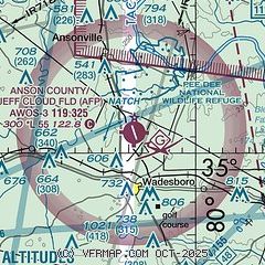
|
| Airport distance calculator |
|---|
|
|
| Sunrise and sunset |
|---|
|
Times for 02-Oct-2026
| | Local
(UTC-4) | | Zulu
(UTC) |
|---|
| Morning civil twilight | | 06:52 | | 10:52 |
| Sunrise | | 07:17 | | 11:17 |
| Sunset | | 19:03 | | 23:03 |
| Evening civil twilight | | 19:28 | | 23:28 |
|
| Current date and time |
|---|
| Zulu (UTC) | 02-Oct-2026 21:04:21 |
|---|
| Local (UTC-4) | 02-Oct-2026 17:04:21 |
|---|
|
| METAR |
|---|
| KAFP | 022055Z AUTO 00000KT 10SM CLR 32/17 A3003 RMK AO2 T03190171
|
KRCZ
17nm SE | 022055Z AUTO 24003KT 10SM SCT065 31/18 A3003 RMK AO2 T03110175
|
KCQW
19nm S | 022055Z AUTO 22005KT 10SM SCT065 SCT075 32/18 A3003 RMK AO2
|
|
| TAF |
|---|
KCLT
44nm W | 021946Z 0220/0324 23007KT P6SM FEW045 FEW250 FM030100 21004KT P6SM FEW080 SCT200 FM031000 00000KT P6SM SCT040 FM031500 05004KT P6SM VCSH BKN070 TEMPO 0315/0318 4SM -SHRA OVC025 FM031800 06006KT 4SM SHRA FEW009 BKN029
|
|
| NOTAMs |
|---|
NOTAMs are issued by the DoD/FAA and will open in a separate window not controlled by AirNav.
|
|


