FAA INFORMATION EFFECTIVE 14 MAY 2026
Location
| FAA Identifier: | ANJ |
| Lat/Long: | 46-28-45.2000N 084-22-06.2000W
46-28.753333N 084-22.103333W
46.4792222,-84.3683889
(estimated) |
| Elevation: | 716.4 ft. / 218.4 m (surveyed) |
| Variation: | 07W (2010) |
| From city: | 1 mile SW of SAULT STE MARIE, MI |
| Time zone: | UTC -4 (UTC -5 during Standard Time) |
| Zip code: | 49783 |
Airport Operations
| Airport use: | Open to the public |
| Activation date: | 04/1940 |
| Control tower: | no |
| ARTCC: | TORONTO CENTER |
| FSS: | GREEN BAY FLIGHT SERVICE STATION |
| NOTAMs facility: | ANJ (NOTAM-D service available) |
| Attendance: | 0800-1700 |
| Wind indicator: | yes |
| Segmented circle: | yes |
| Lights: | ACTVT REIL RWY 14 & 32; PAPI RWY 14 & 32; MIRL RWY 14/32 - CTAF. |
| International operations: | international airport of entry |
Airport Communications
| CTAF/UNICOM: | 122.7 |
| WX ASOS: | 118.375 (906-442-4144) |
| WX AWOS-3PT at CIU (14 nm S): | 127.575 (906-495-1156) |
- APCH/DEP SVC PRVDD BY TORONTO ARTCC ON FREQS 132.65/344.5 (SAULT ENROUTE).
- APCH/DEP SVC PRVDD BY SAULT STE MARIE ONTARIO ON FREQS 118.8/236.6.
Nearby radio navigation aids
| VOR radial/distance | | VOR name | | Freq | | Var |
|---|
| SSMr335/4.6 | | SAULT STE MARIE VOR/DME | | 112.20 | | 04W |
| NDB name | | Hdg/Dist | | Freq | | Var | | ID |
|---|
| KOLOE | | 046/11.4 | | 400 | | 07W | | CI | -.-. .. |
Airport Services
| Fuel available: | 100LL JET-A+
100LL:FUEL AVBL H24 SELF SVC VIA CREDIT CARD. |
| Parking: | hangars and tiedowns |
| Airframe service: | MAJOR |
| Powerplant service: | MAJOR |
Runway Information
Runway 14/32
| Dimensions: | 5234 x 100 ft. / 1595 x 30 m |
| Surface: | asphalt/treated/porous friction courses, in good condition |
| Runway edge lights: | medium intensity |
| RUNWAY 14 | | RUNWAY 32 |
| Latitude: | 46-29.062053N | | 46-28.443798N |
| Longitude: | 084-22.537888W | | 084-21.670228W |
| Elevation: | 695.9 ft. | | 715.9 ft. |
| Traffic pattern: | left | | right |
| Runway heading: | 143 magnetic, 136 true | | 323 magnetic, 316 true |
| Displaced threshold: | 180 ft. | | 178 ft. |
| Markings: | nonprecision, in good condition | | nonprecision, in good condition |
| Visual slope indicator: | 2-light PAPI on left (3.00 degrees glide path) | | 2-light PAPI on left (3.00 degrees glide path) |
| Runway end identifier lights: | yes | | yes |
| Touchdown point: | yes, no lights | | yes, no lights |
| Obstructions: | none
+5 FT FENCE, 130 FT DIST, 250 FT L/R. | | 10 ft. road, 200 ft. from runway, 200 ft. right of centerline, 1:1 slope to clear
+6 FT FENCE, 201 FT DIST, 126 FT R. |
Airport Ownership and Management from official FAA records
| Ownership: | Publicly-owned |
| Owner: | CITY OF SAULT SAINTE MARIE
225 E PORTAGE AVE
SAULT SAINTE MARIE, MI 49783-2053
Phone 906-635-5700 |
| Manager: | TOM BROWN
2144 MERIDIAN ST
SAULT SAINTE MARIE, MI 49783-2608
Phone 906-635-0252
CELL 906-748-1468. |
Additional Remarks
| - | US CUSTOMS AVBL ON REQ CALL 906-632-2631 1 HR PRIOR TO ARR. |
| - | DEER, BIRDS, & WILDLIFE ON & INVOF ARPT. |
| - | PILOTS OPRG IN CANADIAN/US CLASS D ASP ARE RQRD TO ESTAB & MNTN TWO-WAY COM & OBTAIN ATC CLNC FM SAULT STE MARIE ATCT (SOO TWR 118.8) PRIOR TO OPRG IN THE CLASS D ASP. TFC ADZY SER (118.8) IS AVBL IN THE US CLASS E SFC EXTN 0630-2230. |
| - | 50 FT DROP OFF, N END, 200 FT FR RWY END. |
| - | FOR CD CTC MINNEAPOLIS ARTCC AT 651-463-5588. |
Instrument Procedures
NOTE: All procedures below are presented as PDF files. If you need a reader for these files, you should download the free Adobe Reader.NOT FOR NAVIGATION. Please procure official charts for flight.
FAA instrument procedures published for use from 14 May 2026 at 0901Z to 11 June 2026 at 0900Z.
IAPs - Instrument Approach Procedures |
|---|
| RNAV (GPS) RWY 14 | |
download (235KB) |
| RNAV (GPS) RWY 32 | |
download (221KB) |
| VOR RWY 32 | |
download (191KB) |
| NOTE: Special Alternate Minimums apply | |
download (155KB) |
| NOTE: Special Take-Off Minimums/Departure Procedures apply | |
download (328KB) |
Other nearby airports with instrument procedures:
KCIU - Chippewa County International Airport (14 nm S)
KDRM - Drummond Island Airport (38 nm SE)
83D - Mackinac County Airport (38 nm SW)
KMCD - Mackinac Island Airport (39 nm S)
6Y1 - Bois Blanc Island Airport (43 nm S)
|
|

Road maps at:
MapQuest
Bing
Google
| Aerial photo |
|---|
WARNING: Photo may not be current or correct

Do you have a better or more recent aerial photo of Sault Ste Marie Municipal Airport/Sanderson Field that you would like to share? If so, please send us your photo.
|
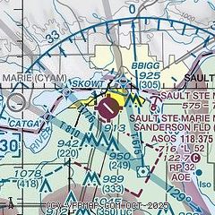
| Sectional chart |
|---|
|
CAUTION: Diagram may not be current

| Airport distance calculator |
|---|
|
|
| Sunrise and sunset |
|---|
|
Times for 30-May-2026
| | Local
(UTC-4) | | Zulu
(UTC) |
|---|
| Morning civil twilight | | 05:13 | | 09:13 |
| Sunrise | | 05:51 | | 09:51 |
| Sunset | | 21:19 | | 01:19 |
| Evening civil twilight | | 21:57 | | 01:57 |
|
| Current date and time |
|---|
| Zulu (UTC) | 31-May-2026 02:36:44 |
|---|
| Local (UTC-4) | 30-May-2026 22:36:44 |
|---|
|
| METAR |
|---|
| KANJ | 310155Z AUTO 00000KT 10SM CLR 14/02 A3022 RMK AO2 SLP233 T01390022
|
CYAM
6nm W | 310200Z 00000KT 20SM FEW220 09/05 A3022 RMK CI2 SLP240
|
KCIU
14nm S | 310156Z AUTO 21003KT 10SM CLR 15/00 A3023 RMK AO2 SLP236 T01500000
|
|
| TAF |
|---|
CYAM
6nm W | 310140Z 3102/3114 VRB03KT P6SM SKC BECMG 3112/3114 30008KT RMK NXT FCST BY 310800Z
|
KCIU
14nm S | 301930Z 3020/3118 11009KT P6SM SKC FM302300 VRB03KT P6SM SKC FM311100 29005KT P6SM SKC
|
|
| NOTAMs |
|---|
NOTAMs are issued by the DoD/FAA and will open in a separate window not controlled by AirNav.
|
|


