FAA INFORMATION EFFECTIVE 27 NOVEMBER 2025
Location
| FAA Identifier: | AQP |
| Lat/Long: | 45-13-39.0063N 096-00-16.3059W
45-13.650105N 096-00.271765W
45.2275018,-96.0045294
(estimated) |
| Elevation: | 1021 ft. / 311.2 m (surveyed) |
| Variation: | 05E (1995) |
| From city: | 2 miles NE of APPLETON, MN |
| Time zone: | UTC -6 (UTC -5 during Daylight Saving Time) |
| Zip code: | 56208 |
Airport Operations
| Airport use: | Open to the public |
| Activation date: | 06/1942 |
| Control tower: | no |
| ARTCC: | MINNEAPOLIS CENTER |
| FSS: | PRINCETON FLIGHT SERVICE STATION |
| NOTAMs facility: | AQP (NOTAM-D service available) |
| Attendance: | UNATNDD |
| Wind indicator: | lighted |
| Segmented circle: | no |
| Lights: | ACTVT MIRL RY 13/31 - CTAF. |
| Beacon: | white-green (lighted land airport)
Operates sunset to sunrise. |
Airport Communications
| CTAF: | 122.9 |
| WX AWOS-3: | 118.5 (320-289-1265) |
| WX AWOS-3PT at BBB (16 nm NE): | 118.45 (320-843-3242) |
| WX AWOS-3 at DXX (16 nm SW): | 118.975 (320-598-3863) |
| WX AWOS-3 at VVV (18 nm W): | 119.225 (320-839-2363) |
| WX AWOS-3PT at MVE (20 nm SE): | 119.675 (320-269-5830) |
- COMMUNICATIONS PRVDD BY PRINCETON RADIO ON FREQ 122.4 (MONTEVIDEO RCO).
- APCH/DEP SVC PRVDD BY MINNEAPOLIS ARTCC (ZMP) ON FREQS 127.1/290.2 (REDWOOD FALLS RCAG).
Nearby radio navigation aids
| VOR radial/distance | | VOR name | | Freq | | Var |
|---|
| MVEr316/19.7 | | MONTEVIDEO VOR/DME | | 111.60 | | 05E |
| MOXr179/20.3 | | MORRIS VOR/DME | | 109.60 | | 05E |
| BDHr276/37.7 | | WILLMAR VOR/DME | | 113.70 | | 04E |
Airport Services
| Parking: | tiedowns |
| Airframe service: | NONE |
| Powerplant service: | NONE |
| Bottled oxygen: | NONE |
| Bulk oxygen: | NONE |
Runway Information
Runway 13/31
| Dimensions: | 3500 x 75 ft. / 1067 x 23 m |
| Surface: | asphalt, in fair condition
CRACKING. |
| Runway edge lights: | medium intensity
RY 13 VISUAL LIGHTING ON INSTRUMENT RY. |
| RUNWAY 13 | | RUNWAY 31 |
| Latitude: | 45-13.817333N | | 45-13.407000N |
| Longitude: | 096-00.514000W | | 095-59.941833W |
| Elevation: | 1020.0 ft. | | 1018.7 ft. |
| Traffic pattern: | left | | left |
| Runway heading: | 130 magnetic, 135 true | | 310 magnetic, 315 true |
| Markings: | nonprecision, in good condition | | nonprecision, in good condition |
| Touchdown point: | yes, no lights | | yes, no lights |
Runway 4/22
| Dimensions: | 2770 x 157 ft. / 844 x 48 m |
| Surface: | turf, in good condition |
| Runway edge markings: | MKD WITH YELLOW CONES. |
| Operational restrictions: | CLOSED WINTER MONTHS. |
| RUNWAY 4 | | RUNWAY 22 |
| Latitude: | 45-13.537667N | | 45-13.860000N |
| Longitude: | 096-00.556167W | | 096-00.100000W |
| Elevation: | 1019.0 ft. | | 1021.0 ft. |
| Traffic pattern: | left | | left |
| Runway heading: | 040 magnetic, 045 true | | 220 magnetic, 225 true |
| Markings: | NSTD, in good condition | | NSTD, in good condition |
| Touchdown point: | yes, no lights | | yes, no lights |
Airport Ownership and Management from official FAA records
| Ownership: | Publicly-owned |
| Owner: | CITY OF APPLETON
323 W. SCHLIEMAN AVE.
APPLETON, MN 56208
Phone 320-289-1363 |
| Manager: | GREG RUETHER
149 S MUNSTERMAN
APPLETON, MN 56208
Phone (320) 413-0089 |
Additional Remarks
| - | FOR CD CTC MINNEAPOLIS ARTCC AT 651-463-5588. |
Instrument Procedures
NOTE: All procedures below are presented as PDF files. If you need a reader for these files, you should download the free Adobe Reader.NOT FOR NAVIGATION. Please procure official charts for flight.
FAA instrument procedures published for use from 27 November 2025 at 0901Z to 25 December 2025 at 0900Z.
IAPs - Instrument Approach Procedures |
|---|
| RNAV (GPS) RWY 13 | |
download (190KB) |
| NOTE: Special Alternate Minimums apply | |
download (152KB) |
| NOTE: Special Take-Off Minimums/Departure Procedures apply | |
download (406KB) |
Other nearby airports with instrument procedures:
KBBB - Benson Municipal Airport (16 nm NE)
KDXX - Lac Qui Parle County Airport (16 nm SW)
KVVV - Ortonville Municipal Airport/Martinson Field (18 nm W)
KMVE - Montevideo-Chippewa County Airport (20 nm SE)
KMOX - Morris Municipal Airport - Charlie Schmidt Field (20 nm N)
|
|

Road maps at:
MapQuest
Bing
Google
| Aerial photo |
|---|
WARNING: Photo may not be current or correct
 Photo by Kreg Anderson
Photo taken 23-Sep-2012
looking west.
Photo by Kreg Anderson
Photo taken 23-Sep-2012
looking west.
Do you have a better or more recent aerial photo of Appleton Municipal Airport that you would like to share? If so, please send us your photo.
|
| Sectional chart |
|---|
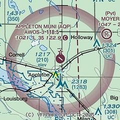
|
| Airport distance calculator |
|---|
|
|
| Sunrise and sunset |
|---|
|
Times for 04-Dec-2025
| | Local
(UTC-6) | | Zulu
(UTC) |
|---|
| Morning civil twilight | | 07:14 | | 13:14 |
| Sunrise | | 07:47 | | 13:47 |
| Sunset | | 16:41 | | 22:41 |
| Evening civil twilight | | 17:15 | | 23:15 |
|
| Current date and time |
|---|
| Zulu (UTC) | 04-Dec-2025 09:08:10 |
|---|
| Local (UTC-6) | 04-Dec-2025 03:08:10 |
|---|
|
| METAR |
|---|
| KAQP | 040853Z AUTO 00000KT 10SM CLR M21/M23 A3038 RMK AO2 TSNO
|
KBBB
16nm E | 040847Z 00000KT 10SM CLR A3038 RMK AO2
|
KDXX
16nm SW | 040855Z AUTO 00000KT 10SM CLR M23/M26 A3039 RMK AO2
|
KVVV
18nm W | 040855Z AUTO 00000KT 10SM CLR M22/M23 A3036 RMK AO2
|
KMVE
20nm SE | 040855Z AUTO 23003KT 10SM CLR M22/M24 A3039 RMK AO2
|
|
| TAF |
|---|
KAXN
46nm NE | 040520Z 0406/0506 24005KT P6SM FEW250 FM041000 19004KT P6SM FEW250 FM041600 18015G24KT P6SM SCT250 FM042200 18015G24KT P6SM BKN025 FM050200 22009KT P6SM BKN018
|
|
| NOTAMs |
|---|
NOTAMs are issued by the DoD/FAA and will open in a separate window not controlled by AirNav.
|
|

