FAA INFORMATION EFFECTIVE 09 JULY 2026
Location
| FAA Identifier: | ASX |
| Lat/Long: | 46-32-54.7000N 090-55-08.3000W
46-32.911667N 090-55.138333W
46.5485278,-90.9189722
(estimated) |
| Elevation: | 826.5 ft. / 251.9 m (surveyed) |
| Variation: | 02W (2015) |
| From city: | 2 miles SW of ASHLAND, WI |
| Time zone: | UTC -5 (UTC -6 during Standard Time) |
| Zip code: | 54806 |
Airport Operations
| Airport use: | Open to the public |
| Activation date: | 09/1958 |
| Control tower: | no |
| ARTCC: | MINNEAPOLIS CENTER |
| FSS: | GREEN BAY FLIGHT SERVICE STATION |
| NOTAMs facility: | ASX (NOTAM-D service available) |
| Attendance: | MON-FRI 0800-1600
FOR SVC AFTER HRS CALL 715-292-7070. |
| Wind indicator: | lighted |
| Segmented circle: | no |
| Lights: | MIRL RWY 02/20 PRESET TO LOW SS-SR; TO INCR INTST AND ACTVT REIL RWY 02 & 20; PAPI RWY 02, 20, & 31; MIRL RWY 02/20 & 13/31 - CTAF. |
| Beacon: | white-green (lighted land airport)
Operates sunset to sunrise. |
Airport Communications
| CTAF/UNICOM: | 122.8 |
| WX ASOS: | 126.775 (715-682-5541) |
| WX AWOS-3PT at 4R5 (16 nm NE): | 119.375 (715-747-5519) |
- APCH/DEP SVC PRVDD BY MINNEAPOLIS ARTCC ON FREQS 126.45/276.4(HAYWARD RCAG).
Nearby radio navigation aids
| VOR radial/distance | | VOR name | | Freq | | Var |
|---|
| IWDr271/32.7 | | IRONWOOD VOR/DME | | 108.80 | | 01E |
Airport Services
| Fuel available: | 100LL JET-A+
100LL:JET A+ PPR CTC AMGR 715-682-7070, AFT HRS CALL 715-292-7070. 24 HR SELF SERVE 100LL. |
| Parking: | hangars and tiedowns |
| Airframe service: | NONE |
| Powerplant service: | NONE |
| Bottled oxygen: | NONE |
| Bulk oxygen: | NONE |
Runway Information
Runway 2/20
| Dimensions: | 5197 x 100 ft. / 1584 x 30 m |
| Surface: | asphalt, in excellent condition |
| Weight bearing capacity: | | Single wheel: | 40.0 | | Double wheel: | 56.0 |
|
| Runway edge lights: | medium intensity |
| RUNWAY 2 | | RUNWAY 20 |
| Latitude: | 46-32.433057N | | 46-33.232600N |
| Longitude: | 090-55.479160W | | 090-55.039750W |
| Elevation: | 818.9 ft. | | 823.2 ft. |
| Traffic pattern: | left | | left |
| Runway heading: | 023 magnetic, 021 true | | 203 magnetic, 201 true |
| Markings: | nonprecision, in good condition | | nonprecision, in good condition |
| Visual slope indicator: | 4-light PAPI on left (3.00 degrees glide path) | | 4-light PAPI on right (3.00 degrees glide path) |
| Runway end identifier lights: | yes | | yes |
| Touchdown point: | yes, no lights | | yes, no lights |
| Instrument approach: | LOC/DME | | |
| Obstructions: | 69 ft. trees, 2215 ft. from runway, 520 ft. right of centerline, 29:1 slope to clear | | none |
Runway 13/31
| Dimensions: | 3498 x 75 ft. / 1066 x 23 m |
| Surface: | asphalt, in fair condition |
| Weight bearing capacity: | | Single wheel: | 40.0 | | Double wheel: | 50.0 |
|
| Runway edge lights: | medium intensity |
| RUNWAY 13 | | RUNWAY 31 |
| Latitude: | 46-33.215497N | | 46-32.841658N |
| Longitude: | 090-55.276762W | | 090-54.642742W |
| Elevation: | 824.1 ft. | | 809.9 ft. |
| Traffic pattern: | left | | left |
| Runway heading: | 133 magnetic, 131 true | | 313 magnetic, 311 true |
| Markings: | nonprecision, in good condition | | nonprecision, in good condition |
| Visual slope indicator: | | | 2-light PAPI on left (3.00 degrees glide path) |
| Runway end identifier lights: | no | | no |
| Touchdown point: | yes, no lights | | yes, no lights |
| Obstructions: | 8 ft. fence, 200 ft. from runway, 220 ft. right of centerline
CTLNG OBSTN EXCEEDS A 45 DEG SLP. | | 49 ft. trees, 1135 ft. from runway, 340 ft. right of centerline, 19:1 slope to clear |
Airport Ownership and Management from official FAA records
| Ownership: | Publicly-owned |
| Owner: | COUNTY & CITY OF ASHLAND
601 MAIN STREET WEST
ASHLAND, WI 54806
Phone 715-682-7071 |
| Manager: | ANDREW KUNDEL
50511 STATE HIGHWAY 112
ASHLAND, WI 54806
Phone 715-682-7070 |
Additional Remarks
| A39-02/20 | PCR VALUE: 160/F/D/X/T |
| - | DEER & OTR WILDLIFE ON & INVOF ARPT. HVY BIRD ACT SPRING & SUMMER MONTHS. |
| - | ACFT OVER 4000 LBS MUST STOP OR PARK ON CONC; ALL OTR ACFT PARK ON ASPH. |
| - | GCO AVBL ON FREQ 122.25 THRU FLT SVCS. |
| - | FOR CD IF UNA TO CTC ON FSS FREQ, CTC MINNEAPOLIS ARTCC AT 651-463-5588. |
Instrument Procedures
NOTE: All procedures below are presented as PDF files. If you need a reader for these files, you should download the free Adobe Reader.NOT FOR NAVIGATION. Please procure official charts for flight.
FAA instrument procedures published for use from 09 July 2026 at 0901Z to 06 August 2026 at 0900Z.
IAPs - Instrument Approach Procedures |
|---|
| RNAV (GPS) RWY 02 | |
download (243KB) |
| RNAV (GPS) RWY 13 | |
download (264KB) |
| RNAV (GPS) RWY 20 | |
download (264KB) |
| RNAV (GPS) RWY 31 | |
download (254KB) |
| LOC RWY 02 | |
download (245KB) |
| NOTE: Special Alternate Minimums apply | |
download (140KB) |
| NOTE: Special Take-Off Minimums/Departure Procedures apply | |
download (484KB) |
Other nearby airports with instrument procedures:
4R5 - Major Gilbert Field Airport (16 nm NE)
3CU - Cable Union Airport (25 nm SW)
KIWD - Gogebic/Iron County Airport (33 nm E)
KHYR - Sawyer County Airport (38 nm SW)
KOLG - Solon Springs Municipal Airport (40 nm W)
|
|

Road maps at:
MapQuest
Bing
Google
| Aerial photo |
|---|
WARNING: Photo may not be current or correct
 Photo by Mark Robinson
www.wemakepilots.com
Photo taken 13-Jul-2020
looking south.
Do you have a better or more recent aerial photo of John F Kennedy Memorial Airport that you would like to share? If so, please send us your photo.
|
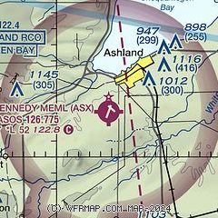
| Sectional chart |
|---|
|
| Airport distance calculator |
|---|
|
|
| Sunrise and sunset |
|---|
|
Times for 02-Aug-2026
| | Local
(UTC-5) | | Zulu
(UTC) |
|---|
| Morning civil twilight | | 05:12 | | 10:12 |
| Sunrise | | 05:47 | | 10:47 |
| Sunset | | 20:33 | | 01:33 |
| Evening civil twilight | | 21:08 | | 02:08 |
|
| Current date and time |
|---|
| Zulu (UTC) | 02-Aug-2026 15:40:12 |
|---|
| Local (UTC-5) | 02-Aug-2026 10:40:12 |
|---|
|
| METAR |
|---|
| KASX | 021518Z AUTO 02004KT 10SM SCT013 21/17 A3004 RMK AO2 RAE14 P0000 T02110167
|
K4R5
16nm NE | 021515Z AUTO 07004KT 10SM BKN110 20/15 A3003 RMK AO2 T02030153
|
|
| TAF |
|---|
KIWD
33nm E | 021255Z 0213/0312 00000KT 1/4SM FG OVC003 FM021400 00000KT 2SM BR SCT020 FM021500 VRB03KT 6SM BR FEW030 FM021600 04005KT P6SM FEW230 FM021800 01007KT P6SM SKC FM030100 VRB03KT P6SM SKC
|
KHYR
39nm SW | 021124Z 0212/0312 VRB05KT P6SM SCT150 TEMPO 0212/0214 1/4SM FG BKN002
|
|
| NOTAMs |
|---|
NOTAMs are issued by the DoD/FAA and will open in a separate window not controlled by AirNav.
|
|

