FAA INFORMATION EFFECTIVE 09 JULY 2026
Location
| FAA Identifier: | AUG |
| Lat/Long: | 44-19-14.4730N 069-47-50.3110W
44-19.241217N 069-47.838517W
44.3206869,-69.7973086
(estimated) |
| Elevation: | 351.7 ft. / 107.2 m (surveyed) |
| Variation: | 18W (1985) |
| From city: | 1 mile NW of AUGUSTA, ME |
| Time zone: | UTC -4 (UTC -5 during Standard Time) |
| Zip code: | 04330 |
Airport Operations
| Airport use: | Open to the public |
| Activation date: | 04/1940 |
| Control tower: | no |
| ARTCC: | BOSTON CENTER |
| FSS: | BANGOR FLIGHT SERVICE STATION |
| NOTAMs facility: | AUG (NOTAM-D service available) |
| Attendance: | 0700-2000
ARPT UNATNDD AFT DARK DURG SN & ICE SEASON. FLD COND RPRTS, SN DEPTHS & BA MAY NOT BE AVBL FOR RWYS FM 1800-0600. |
| Pattern altitude: | 1399.7 ft. MSL |
| Wind indicator: | lighted |
| Segmented circle: | yes |
| Lights: | ACTVT MALSR RWY 17; REIL RWY 35; PAPI RWY 17 & 35; HIRL RWY 17/35; MIRL RWY 08/26 - CTAF. |
| Beacon: | white-green (lighted land airport)
Operates sunset to sunrise. |
| Landing fee: | yes |
Airport Communications
| CTAF/UNICOM: | 123.0 |
| WX ASOS: | 118.325 (207-623-0432) |
| PORTLAND APPROACH: | 128.35 |
| PORTLAND DEPARTURE: | 128.35 |
| CLEARANCE DELIVERY: | 119.95 |
| WX AWOS-3PT at WVL (14 nm N): | 118.375 (207-877-0519) |
- APCH/DEP SVC PRVDD BY BOSTON ARTCC ON FREQS 128.2/263.05 (112-292) (WATERBORO RCAG); FREQS 120.25/290.50 (293-111) (BANGOR RCAG) WHEN PORTLAND APCH CTL CLSD.
Nearby radio navigation aids
| VOR radial/distance | | VOR name | | Freq | | Var |
|---|
| AUG at field | | AUGUSTA VOR/DME | | 114.95 | | 18W |
| NDB name | | Hdg/Dist | | Freq | | Var | | ID |
|---|
| DUNNS | | 171/6.1 | | 366 | | 18W | | AU | .- ..- |
| BURNHAM | | 238/29.4 | | 348 | | 18W | | BUP | -... ..- .--. |
Airport Services
| Fuel available: | 100LL JET-A
100LL:FOR FUEL AFT NML BUS HRS CALL 207-622-2507. |
| Parking: | hangars and tiedowns |
| Airframe service: | MAJOR |
| Powerplant service: | MAJOR |
| Bottled oxygen: | NONE |
| Bulk oxygen: | NONE |
Runway Information
Runway 17/35
| Dimensions: | 5002 x 100 ft. / 1525 x 30 m |
| Surface: | asphalt/grooved, in good condition |
| Weight bearing capacity: | | Single wheel: | 50.0 | | Double wheel: | 60.0 |
|
| Runway edge lights: | high intensity |
| RUNWAY 17 | | RUNWAY 35 |
| Latitude: | 44-19.659385N | | 44-18.925345N |
| Longitude: | 069-48.220625W | | 069-47.701787W |
| Elevation: | 310.7 ft. | | 347.2 ft. |
| Traffic pattern: | left | | left |
| Runway heading: | 171 magnetic, 153 true | | 351 magnetic, 333 true |
| Declared distances: | TORA:5002 TODA:5002 ASDA:5002 LDA:5002 | | TORA:5002 TODA:5002 ASDA:5002 LDA:5002 |
| Markings: | precision, in good condition | | precision, in good condition |
| Visual slope indicator: | 4-light PAPI on left (3.00 degrees glide path) | | 4-light PAPI on left (3.00 degrees glide path) |
| Approach lights: | MALSR: 1,400 foot medium intensity approach lighting system with runway alignment indicator lights | | |
| Runway end identifier lights: | | | yes |
| Touchdown point: | yes, no lights | | yes, no lights |
| Instrument approach: | ILS | | |
| Obstructions: | 6 ft. tree, 210 ft. from runway, 20 ft. left of centerline, 1:1 slope to clear
7-8 FT BRUSH 190 FT FM THR, 110-120 FT R OF CNTRLN. | | 8 ft. tree, lighted, 201 ft. from runway, 90 ft. right of centerline
ROAD 240 FT R, 0-200 FT; 3-7 FT BRUSH 195-200 FT FM THR, 65-130 FT R OF CNTRLN. |
Runway 8/26
| Dimensions: | 2613 x 75 ft. / 796 x 23 m |
| Surface: | asphalt, in fair condition |
| Weight bearing capacity: | |
| Runway edge lights: | medium intensity |
| RUNWAY 8 | | RUNWAY 26 |
| Latitude: | 44-19.042498N | | 44-19.244105N |
| Longitude: | 069-47.868303W | | 069-47.339172W |
| Elevation: | 349.4 ft. | | 351.6 ft. |
| Traffic pattern: | left | | left |
| Runway heading: | 080 magnetic, 062 true | | 260 magnetic, 242 true |
| Declared distances: | TORA:2613 TODA:2613 ASDA:2613 LDA:2613 | | TORA:2613 TODA:2613 ASDA:2613 LDA:2613 |
| Markings: | nonprecision, in good condition | | nonprecision, in good condition |
| Runway end identifier lights: | no | | no |
| Touchdown point: | yes, no lights | | yes, no lights |
| Obstructions: | 16 ft. trees, 287 ft. from runway, 80 ft. left of centerline, 5:1 slope to clear | | 6 ft. fence, lighted, 201 ft. from runway, 131 ft. left of centerline
ROAD & FENCE L OF APCH, 0-200 FT FM RWY END, LGTD. |
Airport Ownership and Management from official FAA records
| Ownership: | Publicly-owned |
| Owner: | STATE OF MAINE
16 STATE HOUSE STATION
AUGUSTA, ME 04333
Phone 207-624-3250 |
| Manager: | JOHN GUIMOND
75 AIRPORT RD
AUGUSTA, ME 04330
Phone 207-626-2306 |
Additional Remarks
| E60-35 | ENGINEERED MATERIALS ARRESTING SYSTEM (EMAS) 150 FT IN LENGTH BY 122 FT IN WIDTH LCTD AT DER 35. |
| E60-17 | ENGINEERED MATERIALS ARRESTING SYSTEM (EMAS) 130 FT IN LENGTH BY 122 FT IN WIDTH LCTD AT DER 17. |
| - | RWY 35 DESIGNATED CALM WIND RWY. |
| - | ACR RAMP CLSD TO GA TFC. |
| - | RWY 17/35 HAVE EMAS CATEGORY B2. |
| - | FOR CD WHEN PORTLAND APCH CLSD, CTC BOSTON ARTCC AT 603-879-6859. |
| - | PILOTS CONDUCTING EFVS OPS; BE AWARE LED ALS IN USE RWY 17. |
| - | TWY F EAST CLSD TO ALL ACFT WITH WING SPAN GTR THAN 45 FT. |
| - | LDG FEE FOR MULTI-ENG ACFT; FEE WAIVED WITH FUEL PURCHASE. |
| - | BIRDS & DEER ON & INVOF ARPT. |
Instrument Procedures
NOTE: All procedures below are presented as PDF files. If you need a reader for these files, you should download the free Adobe Reader.NOT FOR NAVIGATION. Please procure official charts for flight.
FAA instrument procedures published for use from 09 July 2026 at 0901Z to 06 August 2026 at 0900Z.
IAPs - Instrument Approach Procedures |
|---|
| ILS OR LOC RWY 17 | |
download (353KB) |
| RNAV (GPS) RWY 17 | |
download (295KB) |
| RNAV (GPS) RWY 35 | |
download (258KB) |
| NOTE: Special Alternate Minimums apply | |
download (150KB) |
| NOTE: Special Take-Off Minimums/Departure Procedures apply | |
download (514KB) |
Other nearby airports with instrument procedures:
KWVL - Waterville Regional Airport (14 nm N)
KIWI - Wiscasset Airport (22 nm S)
KOWK - Central Maine/Norridgewock Airport (24 nm N)
KBXM - Brunswick Executive Airport (26 nm S)
KLEW - Auburn/Lewiston Municipal Airport (27 nm SW)
|
|

Road maps at:
MapQuest
Bing
Google
| Aerial photo |
|---|
WARNING: Photo may not be current or correct
 Photo taken 08-Dec-2014
looking northeast.
Photo taken 08-Dec-2014
looking northeast.
Do you have a better or more recent aerial photo of Augusta State Airport that you would like to share? If so, please send us your photo.
|
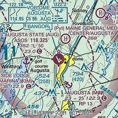
| Sectional chart |
|---|
|
CAUTION: Diagram may not be current

| Airport distance calculator |
|---|
|
|
| Sunrise and sunset |
|---|
|
Times for 01-Aug-2026
| | Local
(UTC-4) | | Zulu
(UTC) |
|---|
| Morning civil twilight | | 04:54 | | 08:54 |
| Sunrise | | 05:27 | | 09:27 |
| Sunset | | 20:04 | | 00:04 |
| Evening civil twilight | | 20:37 | | 00:37 |
|
| Current date and time |
|---|
| Zulu (UTC) | 01-Aug-2026 16:11:19 |
|---|
| Local (UTC-4) | 01-Aug-2026 12:11:19 |
|---|
|
| METAR |
|---|
| KAUG | 011553Z AUTO VRB05KT 10SM CLR 28/17 A2995 RMK AO2 SLP140 T02780167
|
KWVL
13nm NE | 011556Z AUTO 06004KT 10SM CLR 26/18 A2993 RMK AO2 SLP138 T02610178
|
|
| TAF |
|---|
| KAUG | 011120Z 0112/0212 00000KT P6SM SKC FM011700 17008KT P6SM BKN250
|
|
| NOTAMs |
|---|
NOTAMs are issued by the DoD/FAA and will open in a separate window not controlled by AirNav.
|
|


