FAA INFORMATION EFFECTIVE 09 JULY 2026
Location
| FAA Identifier: | OWK |
| Lat/Long: | 44-42-55.8000N 069-51-59.3000W
44-42.930000N 069-51.988333W
44.7155000,-69.8664722
(estimated) |
| Elevation: | 270.2 ft. / 82.4 m (surveyed) |
| Variation: | 18W (1985) |
| From city: | 4 miles W of NORRIDGEWOCK, ME |
| Time zone: | UTC -4 (UTC -5 during Standard Time) |
| Zip code: | 04957 |
Airport Operations
| Airport use: | Open to the public |
| Activation date: | 02/1944 |
| Control tower: | no |
| ARTCC: | BOSTON CENTER |
| FSS: | BANGOR FLIGHT SERVICE STATION |
| NOTAMs facility: | BGR (NOTAM-D service available) |
| Attendance: | MON-FRI 0700-1400, ALL SAT-SUN UNATNDD |
| Wind indicator: | lighted |
| Segmented circle: | yes |
| Lights: | ACTVT REIL RWY 15 & 33; PAPI RWY 15; MIRL RWY 15/33 - CTAF. |
| Beacon: | white-green (lighted land airport)
Operates sunset to sunrise. |
Airport Communications
| CTAF/UNICOM: | 122.8 |
| WX AWOS-AV: | 123.075 |
| PORTLAND APPROACH: | 128.35 |
| PORTLAND DEPARTURE: | 128.35 |
| WX AWOS-3PT at WVL (14 nm SE): | 118.375 (207-877-0519) |
| WX AWOS-AV at ME23 (14 nm SW): | 122.8 (207-779-3105) |
- APCH/DEP SVC PRVDD BY BOSTON ARTCC ON FREQS 128.2/263.05 (112-292) (WATERBORO RCAG); FREQS 124.25/290.50 (293-111) (BANGOR RCAG) WHEN PORTLAND APCH CTL CLSD.
Nearby radio navigation aids
| VOR radial/distance | | VOR name | | Freq | | Var |
|---|
| AUGr011/23.9 | | AUGUSTA VOR/DME | | 114.95 | | 18W |
| NDB name | | Hdg/Dist | | Freq | | Var | | ID |
|---|
| BURNHAM | | 291/21.7 | | 348 | | 18W | | BUP | -... ..- .--. |
Airport Services
| Fuel available: | 100LL MOGAS
100LL:24 HR FUEL AVBL WITH MAJOR CREDIT CARD. |
| Parking: | tiedowns |
| Airframe service: | MAJOR |
| Powerplant service: | MAJOR |
| Bottled oxygen: | NONE |
| Bulk oxygen: | NONE |
Runway Information
Runway 15/33
| Dimensions: | 4000 x 100 ft. / 1219 x 30 m |
| Surface: | asphalt, in good condition |
| Weight bearing capacity: | | Single wheel: | 30.0 | | Double wheel: | 60.0 |
|
| Runway edge lights: | medium intensity |
| RUNWAY 15 | | RUNWAY 33 |
| Latitude: | 44-43.210152N | | 44-42.790222N |
| Longitude: | 069-52.282647W | | 069-51.571647W |
| Elevation: | 264.1 ft. | | 258.3 ft. |
| Traffic pattern: | left | | left |
| Runway heading: | 148 magnetic, 130 true | | 328 magnetic, 310 true |
| Markings: | nonprecision, in good condition | | basic, in good condition |
| Visual slope indicator: | 2-light PAPI on left (3.00 degrees glide path) | | |
| Runway end identifier lights: | yes | | yes |
| Touchdown point: | yes, no lights | | yes, no lights |
| Obstructions: | 35 ft. tree, 767 ft. from runway, 285 ft. left of centerline, 16:1 slope to clear
10 FT TREES, 90-175 FT FM RWY END, 130-250 FT R. | | none |
Runway 3/21
| Dimensions: | 3998 x 80 ft. / 1219 x 24 m |
| Surface: | asphalt, in fair condition |
| Weight bearing capacity: | | Single wheel: | 30.0 | | Double wheel: | 60.0 |
|
| Runway edge markings: | MRKGS FADED. CNTRLN & THR BARS MISG. |
| RUNWAY 3 | | RUNWAY 21 |
| Latitude: | 44-42.534327N | | 44-43.183090N |
| Longitude: | 069-52.125182W | | 069-51.971068W |
| Elevation: | 265.0 ft. | | 266.2 ft. |
| Traffic pattern: | left | | left |
| Runway heading: | 028 magnetic, 010 true | | 208 magnetic, 190 true |
| Markings: | nonprecision, in poor condition | | basic, in poor condition |
| Touchdown point: | yes, no lights | | yes, no lights |
| Obstructions: | 21 ft. trees, 243 ft. from runway, 121 ft. left of centerline, 2:1 slope to clear
+10 FT -20 FT TREES & BRUSH 75 FT FM THR, 230-250 FT R OF CNTRLN. | | 69 ft. trees, 790 ft. from runway, 180 ft. left of centerline, 8:1 slope to clear
+4-8 FT BRUSH 110-120 FT FM THR, 100 FT L & R OF CNTRLN; +25 FT TREES 100-175 FT FM THR, 185-250 FT L OF CNTRLN. |
Airport Ownership and Management from official FAA records
| Ownership: | Publicly-owned |
| Owner: | TOWN OF NORRIDGEWOCK
PO BOX 7
NORRIDGEWOCK, ME 04957
Phone 207-634-2252 |
| Manager: | RICHARD LABELLE
PO BOX 7
NORRIDGEWOCK, ME 04957
Phone 207-634-2252
ALTN CTC: BRUCE HURLEY 207-449-2995. |
Additional Remarks
| - | BIRDS & DEER ON & INVOF ARPT. |
| - | RWY 21 HAS 30 FT DROPOFF 100 FT FM END OF RWY. |
| - | FOR CD CTC PORTLAND APCH AT 207-874-7320. WHEN PORTLAND APCH CLSD, CTC BOSTON ARTCC AT 603-879-6859. |
Instrument Procedures
NOTE: All procedures below are presented as PDF files. If you need a reader for these files, you should download the free Adobe Reader.NOT FOR NAVIGATION. Please procure official charts for flight.
FAA instrument procedures published for use from 09 July 2026 at 0901Z to 06 August 2026 at 0900Z.
IAPs - Instrument Approach Procedures |
|---|
| RNAV (GPS) RWY 03 | |
download (272KB) |
| RNAV (GPS) RWY 15 | |
download (268KB) |
| NOTE: Special Take-Off Minimums/Departure Procedures apply | |
download (514KB) |
Other nearby airports with instrument procedures:
KWVL - Waterville Regional Airport (14 nm SE)
2B7 - Pittsfield Municipal Airport (21 nm E)
KAUG - Augusta State Airport (24 nm S)
B21 - Sugarloaf Regional Airport (27 nm NW)
1B0 - Dexter Regional Airport (32 nm NE)
|
|

Road maps at:
MapQuest
Bing
Google
| Aerial photo |
|---|
WARNING: Photo may not be current or correct
 Photo by Pete Chaisson Portland Flight Services
Photo taken 07-Sep-2014
looking east.
Photo by Pete Chaisson Portland Flight Services
Photo taken 07-Sep-2014
looking east.
Do you have a better or more recent aerial photo of Central Maine/Norridgewock Airport that you would like to share? If so, please send us your photo.
|
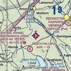
| Sectional chart |
|---|
|
| Airport distance calculator |
|---|
|
|
| Sunrise and sunset |
|---|
|
Times for 30-Jul-2026
| | Local
(UTC-4) | | Zulu
(UTC) |
|---|
| Morning civil twilight | | 04:51 | | 08:51 |
| Sunrise | | 05:24 | | 09:24 |
| Sunset | | 20:07 | | 00:07 |
| Evening civil twilight | | 20:41 | | 00:41 |
|
| Current date and time |
|---|
| Zulu (UTC) | 30-Jul-2026 05:22:03 |
|---|
| Local (UTC-4) | 30-Jul-2026 01:22:03 |
|---|
|
| METAR |
|---|
KWVL
15nm SE | 300456Z AUTO 03005KT 10SM -RA OVC011 18/17 A2981 RMK AO2 SLP097 P0002 T01780172 402330178
|
KAUG
24nm S | 300453Z AUTO 02004KT 10SM -RA OVC008 18/17 A2983 RMK AO2 SLP099 P0002 T01780172 402330172
|
|
| TAF |
|---|
KAUG
24nm S | 291720Z 2918/3018 12010KT P6SM BKN028 OVC050 FM300100 08007KT 2SM -RA BR OVC007
|
|
| NOTAMs |
|---|
NOTAMs are issued by the DoD/FAA and will open in a separate window not controlled by AirNav.
|
|

