FAA INFORMATION EFFECTIVE 09 JULY 2026
Location
| FAA Identifier: | BFD |
| Lat/Long: | 41-48-10.6356N 078-38-23.8775W
41-48.177260N 078-38.397958W
41.8029543,-78.6399660
(estimated) |
| Elevation: | 2143.1 ft. / 653.2 m (surveyed) |
| Variation: | 11W (2010) |
| From city: | 10 miles S of BRADFORD, PA |
| Time zone: | UTC -4 (UTC -5 during Standard Time) |
| Zip code: | 16726 |
Airport Operations
| Airport use: | Open to the public |
| Activation date: | 11/1977 |
| Control tower: | no |
| ARTCC: | CLEVELAND CENTER |
| FSS: | ALTOONA FLIGHT SERVICE STATION |
| NOTAMs facility: | BFD (NOTAM-D service available) |
| Attendance: | MON-FRI 0700-2000, ALL SAT 0700-2000, ALL SUN 0700-2000 |
| Wind indicator: | lighted |
| Segmented circle: | no |
| Lights: | ACTVT MALSR RWY 32; REIL RWY 05, 23 & 14; VASI RWY 14; PAPI RWY 23; MIRL RWY 05/23; HIRL RWY 14/32; TWY LGTS - CTAF. |
| Beacon: | white-green (lighted land airport)
Operates sunset to sunrise. |
| Landing fee: | yes |
| Fire and rescue: | ARFF index A |
| Airline operations: | PPR 24 HRS FOR UNSKED ACFT OPS WITH MORE THAN 30 PSGR SEATS; CALL AMGR 814-368-5928 X 10. INDEX "B" COVERAGE AVBL 0700-2000; AFTER 2000 FOR EMERG CALL MCKEAN COUNTY 911 AT 814-887-4911. |
Airport Communications
| CTAF/UNICOM: | 123.075 |
| WX ASOS: | 133.825 (814-368-2581) |
- APCH/DEP SVC PRVDD BY CLEVELAND ARTCC (ZOB) ON FREQS 124.325/353.85 (WAYLAND RCAG).
Nearby radio navigation aids
| VOR radial/distance | | VOR name | | Freq | | Var |
|---|
| JHWr144/31.6 | | JAMESTOWN VOR/DME | | 114.70 | | 07W |
| SLTr308/34.7 | | SLATE RUN VORTAC | | 113.90 | | 08W |
Airport Services
| Fuel available: | 100LL JET-A+ |
| Parking: | hangars |
| Airframe service: | MINOR |
| Powerplant service: | MINOR |
| Bottled oxygen: | NONE |
| Bulk oxygen: | NONE |
Runway Information
Runway 14/32
| Dimensions: | 6307 x 150 ft. / 1922 x 46 m |
| Surface: | asphalt/grooved, in good condition |
| Weight bearing capacity: | | Single wheel: | 48.0 | | Double wheel: | 60.0 | | Double tandem: | 92.0 |
|
| Runway edge lights: | high intensity |
| RUNWAY 14 | | RUNWAY 32 |
| Latitude: | 41-48.558697N | | 41-47.839067N |
| Longitude: | 078-38.928198W | | 078-37.927852W |
| Elevation: | 2108.2 ft. | | 2100.2 ft. |
| Traffic pattern: | left | | left |
| Runway heading: | 145 magnetic, 134 true | | 325 magnetic, 314 true |
| Declared distances: | TORA:6306 TODA:6306 ASDA:6306 LDA:6306 | | TORA:6306 TODA:6306 ASDA:6306 LDA:6306 |
| Markings: | precision, in fair condition | | precision, in fair condition |
| Visual slope indicator: | 4-box VASI on left (3.00 degrees glide path) | | |
| Approach lights: | | | MALSR: 1,400 foot medium intensity approach lighting system with runway alignment indicator lights
MALSR UNMONITORED. |
| Runway end identifier lights: | yes | | |
| Touchdown point: | yes, no lights | | yes, no lights |
| Instrument approach: | | | ILS |
| Obstructions: | 34 ft. tree, 1179 ft. from runway, 483 ft. right of centerline, 28:1 slope to clear | | 73 ft. tree, 2872 ft. from runway, 863 ft. left of centerline, 36:1 slope to clear |
Runway 5/23
| Dimensions: | 4499 x 100 ft. / 1371 x 30 m |
| Surface: | asphalt/grooved, in good condition |
| Weight bearing capacity: | | Single wheel: | 48.0 | | Double wheel: | 60.0 |
|
| Runway edge lights: | medium intensity |
| RUNWAY 5 | | RUNWAY 23 |
| Latitude: | 41-47.879980N | | 41-48.413918N |
| Longitude: | 078-38.698898W | | 078-38.012717W |
| Elevation: | 2128.8 ft. | | 2143.1 ft. |
| Traffic pattern: | left | | left |
| Runway heading: | 055 magnetic, 044 true | | 235 magnetic, 224 true |
| Declared distances: | TORA:4499 TODA:4499 ASDA:4499 LDA:4499 | | TORA:4499 TODA:4499 ASDA:4499 LDA:4499 |
| Markings: | basic, in good condition | | basic, in good condition |
| Visual slope indicator: | | | 4-light PAPI on left (3.00 degrees glide path) |
| Runway end identifier lights: | yes | | yes |
| Touchdown point: | yes, no lights | | yes, no lights |
| Obstructions: | 13 ft. tree, 331 ft. from runway, 82 ft. left of centerline, 10:1 slope to clear | | 25 ft. tree, 671 ft. from runway, 33 ft. left of centerline, 18:1 slope to clear |
Airport Ownership and Management from official FAA records
| Ownership: | Publicly-owned |
| Owner: | BRADFORD REGIONAL ARPT AUTH
212 AIRPORT DR SUITE E
LEWIS RUN, PA 16738
Phone 814-368-5928 |
| Manager: | ALICIA DANKESREITER
212 AIRPORT DR SUITE E
LEWIS RUN, PA 16738
Phone 814-368-5928
EXT 10 |
Additional Remarks
| A39-05/23 | PCR VALUE: 181/F/D/Y/U |
| A39-14/32 | PCR VALUE: 343/F/D/W/T |
| - | DEER & BIRDS ON & INVOF ARPT. |
| - | AIRCRAFT DEICING AVAIL |
| - | ARPT UNATNDD, NO SNOW REMOVAL AVBL DAILY 2000-0700. |
| - | FOR CD CTC CLEVELAND ARTCC AT 440-774-0227. |
| - | CONDS NOT MNT OUTSIDE NML HRS OF ATNDC. |
Instrument Procedures
NOTE: All procedures below are presented as PDF files. If you need a reader for these files, you should download the free Adobe Reader.NOT FOR NAVIGATION. Please procure official charts for flight.
FAA instrument procedures published for use from 09 July 2026 at 0901Z to 06 August 2026 at 0900Z.
IAPs - Instrument Approach Procedures |
|---|
| ILS OR LOC RWY 32 **CHANGED** | |
download (237KB) |
| RNAV (GPS) RWY 14 **CHANGED** | |
download (270KB) |
| RNAV (GPS) RWY 32 **CHANGED** | |
download (266KB) |
| NOTE: Special Alternate Minimums apply | |
download (127KB) |
| NOTE: Special Take-Off Minimums/Departure Procedures apply | |
download (433KB) |
Other nearby airports with instrument procedures:
KOYM - St Marys Municipal Airport (24 nm S)
KOLE - Cattaraugus County-Olean Airport (29 nm NE)
KELZ - Wellsville Municipal Airport/Tarantine Field (34 nm NE)
KJHW - Chautauqua County/Jamestown Airport (35 nm NW)
KDUJ - Dubois Regional Airport (39 nm S)
|
|

Road maps at:
MapQuest
Bing
Google
| Aerial photo |
|---|
WARNING: Photo may not be current or correct
 Photo by Randall and G. William Kilmer
Taken in May 2009
Photo by Randall and G. William Kilmer
Taken in May 2009
Do you have a better or more recent aerial photo of Bradford Regional Airport that you would like to share? If so, please send us your photo.
|
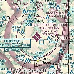
| Sectional chart |
|---|
|
| Airport distance calculator |
|---|
|
|
| Sunrise and sunset |
|---|
|
Times for 09-Jul-2026
| | Local
(UTC-4) | | Zulu
(UTC) |
|---|
| Morning civil twilight | | 05:16 | | 09:16 |
| Sunrise | | 05:49 | | 09:49 |
| Sunset | | 20:50 | | 00:50 |
| Evening civil twilight | | 21:24 | | 01:24 |
|
| Current date and time |
|---|
| Zulu (UTC) | 09-Jul-2026 11:29:54 |
|---|
| Local (UTC-4) | 09-Jul-2026 07:29:54 |
|---|
|
| METAR |
|---|
| KBFD | 091119Z AUTO 00000KT 10SM FEW002 16/16 A3000 RMK AO2 T01610161
|
|
| TAF |
|---|
| KBFD | 090536Z 0906/1006 00000KT 1SM BR VCFG SCT002 FM091300 26005KT P6SM SCT035 BKN180 FM100300 24002KT 5SM BR VCFG BKN035
|
|
| NOTAMs |
|---|
NOTAMs are issued by the DoD/FAA and will open in a separate window not controlled by AirNav.
|
|


