FAA INFORMATION EFFECTIVE 14 MAY 2026
Location
| FAA Identifier: | OLE |
| Lat/Long: | 42-14-28.3000N 078-22-16.9000W
42-14.471667N 078-22.281667W
42.2411944,-78.3713611
(estimated) |
| Elevation: | 2135.4 ft. / 650.9 m (surveyed) |
| Variation: | 11W (2000) |
| From city: | 10 miles N of OLEAN, NY |
| Time zone: | UTC -4 (UTC -5 during Standard Time) |
| Zip code: | 14743 |
Airport Operations
| Airport use: | Open to the public |
| Activation date: | 12/1958 |
| Control tower: | no |
| ARTCC: | CLEVELAND CENTER |
| FSS: | BUFFALO FLIGHT SERVICE STATION |
| NOTAMs facility: | OLE (NOTAM-D service available) |
| Attendance: | 0800-1600
CALL AMGR FOR SVC AVAILABILITY ON HOL. |
| Wind indicator: | lighted |
| Segmented circle: | no |
| Lights: | ACTVT REIL RWY 04 & 22; PAPI RWY 04 & 22; HIRL RWY 04/22; WDI - CTAF. |
| Beacon: | white-green (lighted land airport)
Operates sunset to sunrise. |
Airport Communications
| CTAF/UNICOM: | 122.8 |
| WX AWOS-3: | 118.375 (716-557-2001) |
| WX ASOS at ELZ (19 nm SE): | 119.275 (585-380-1032) |
- APCH/DEP SVC PRVDD BY CLEVELAND ARTCC (ZOB) ON FREQS 124.325/353.85 (WAYLAND RCAG).
Nearby radio navigation aids
| VOR radial/distance | | VOR name | | Freq | | Var |
|---|
| JHWr092/33.5 | | JAMESTOWN VOR/DME | | 114.70 | | 07W |
Airport Services
| Fuel available: | 100LL JET-A+ |
| Parking: | hangars and tiedowns |
| Bottled oxygen: | NONE |
| Bulk oxygen: | NONE |
Runway Information
Runway 4/22
| Dimensions: | 4800 x 100 ft. / 1463 x 30 m |
| Surface: | asphalt/grooved, in fair condition |
| Weight bearing capacity: | | PCN 32 /F/D/X/T | | Single wheel: | 81.0 | | Double wheel: | 103.0 | | Double tandem: | 168.0 |
|
| Runway edge lights: | high intensity |
| RUNWAY 4 | | RUNWAY 22 |
| Latitude: | 42-14.083143N | | 42-14.751800N |
| Longitude: | 078-22.578620W | | 078-22.011940W |
| Elevation: | 2131.5 ft. | | 2112.5 ft. |
| Traffic pattern: | left | | left |
| Runway heading: | 043 magnetic, 032 true | | 223 magnetic, 212 true |
| Displaced threshold: | 100 ft. | | 200 ft. |
| Declared distances: | TORA:4800 TODA:4800 ASDA:4600 LDA:4500 | | TORA:4800 TODA:4800 ASDA:4700 LDA:4500 |
| Markings: | nonprecision, in fair condition | | nonprecision, in fair condition |
| Visual slope indicator: | 2-light PAPI on left (3.00 degrees glide path) | | 2-light PAPI on left (3.00 degrees glide path)
UNUSBL BYD 5 DEGS LEFT OF CNTRLN. |
| Runway end identifier lights: | yes | | yes |
| Touchdown point: | yes, no lights | | yes, no lights |
| Instrument approach: | | | LOCALIZER |
| Obstructions: | 12 ft. trees, 217 ft. from runway, 94 ft. left of centerline, 1:1 slope to clear
42 TO 52 FT TREES, 0-200 FT FM RWY END, 475 FT RIGHT. | | 16 ft. trees, 301 ft. from runway, 430 ft. left of centerline, 6:1 slope to clear
5-15 FT TREES, 50-130 FT FM RWY END, 435 FT LEFT. |
Runway 16/34
| Dimensions: | 2117 x 100 ft. / 645 x 30 m |
| Surface: | turf, in good condition |
| Runway edge markings: | REFLECTIVE EDGE & THLD MARKINGS. |
| RUNWAY 16 | | RUNWAY 34 |
| Latitude: | 42-14.744643N | | 42-14.448260N |
| Longitude: | 078-22.371962W | | 078-22.125088W |
| Elevation: | 2135.3 ft. | | 2117.0 ft. |
| Traffic pattern: | left | | left |
| Runway heading: | 159 magnetic, 148 true | | 339 magnetic, 328 true |
| Markings: | NSTD, in fair condition | | NSTD, in fair condition |
| Touchdown point: | yes, no lights | | yes, no lights |
| Obstructions: | 24 ft. tree, 253 ft. from runway, 92 ft. left of centerline, 10:1 slope to clear | | 27 ft. tree, 262 ft. from runway, 151 ft. left of centerline, 9:1 slope to clear |
Airport Ownership and Management from official FAA records
| Ownership: | Publicly-owned |
| Owner: | CITY OF OLEAN
MUN BLDG
OLEAN, NY 14760
Phone 716-375-5650 |
| Manager: | BRUCE CRANDELL
AIRPORT ROAD(5420 HATCH HILL RD)
HINSDALE, NY 14743
Phone 716-557-8800 |
Additional Remarks
| - | DEER ON & INVOF ARPT. |
| - | SNOW PLOWING & BRAKING ACTION & FIELD COND RPRTS NOT AVBL WHEN ARPT IS UNATNDD. |
| - | TERRAIN DROPS OFF ON ALL RWY ENDS. RWY 4: 250 FT X 250 FT RESA. RWY 22: 225 FT WIDE X 110 FT LONG RESA. |
| - | RWY 16/34 CLSD WINTER MONTHS; SOFT IN SPRING. |
| - | FUEL AVBL 24/7. |
| - | UNMANNED ACFT 1NM RADIUS SFC-500 FT. |
| - | FOR CD CTC CLEVELAND ARTCC AT 440-774-0227. |
Instrument Procedures
NOTE: All procedures below are presented as PDF files. If you need a reader for these files, you should download the free Adobe Reader.NOT FOR NAVIGATION. Please procure official charts for flight.
FAA instrument procedures published for use from 14 May 2026 at 0901Z to 11 June 2026 at 0900Z.
IAPs - Instrument Approach Procedures |
|---|
| RNAV (GPS) RWY 04 **CHANGED** | |
download (201KB) |
| RNAV (GPS) RWY 22 **CHANGED** | |
download (203KB) |
| LOC RWY 22 **CHANGED** | |
download (198KB) |
| NOTE: Special Take-Off Minimums/Departure Procedures apply | |
download (367KB) |
Other nearby airports with instrument procedures:
KELZ - Wellsville Municipal Airport/Tarantine Field (19 nm SE)
KBFD - Bradford Regional Airport (29 nm SW)
KHTF - Hornell Municipal Airport (32 nm E)
KDSV - Dansville Municipal Airport (35 nm NE)
KJHW - Chautauqua County/Jamestown Airport (40 nm W)
|
|

Road maps at:
MapQuest
Bing
Google
| Aerial photo |
|---|
WARNING: Photo may not be current or correct
 Taken in the Summer of 2005
Do you have a better or more recent aerial photo of Cattaraugus County-Olean Airport that you would like to share? If so, please send us your photo.
|
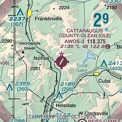
| Sectional chart |
|---|
|
| Airport distance calculator |
|---|
|
|
| Sunrise and sunset |
|---|
|
Times for 22-May-2026
| | Local
(UTC-4) | | Zulu
(UTC) |
|---|
| Morning civil twilight | | 05:14 | | 09:14 |
| Sunrise | | 05:47 | | 09:47 |
| Sunset | | 20:33 | | 00:33 |
| Evening civil twilight | | 21:06 | | 01:06 |
|
| Current date and time |
|---|
| Zulu (UTC) | 22-May-2026 04:59:59 |
|---|
| Local (UTC-4) | 22-May-2026 00:59:59 |
|---|
|
| METAR |
|---|
| KOLE | 220415Z AUTO 10003KT 10SM CLR 06/M02 A3033 RMK AO2
|
KELZ
19nm SE | 220356Z AUTO 06005KT 10SM CLR 08/M03 A3034 RMK AO2 SLP282 T00781028
|
|
| TAF |
|---|
KBFD
29nm SW | 211720Z 2118/2218 09009KT P6SM SCT025 OVC080 FM220200 09003KT P6SM SCT150 SCT250 FM221000 10004KT P6SM OVC035 FM221500 11011G19KT P6SM OVC100
|
|
| NOTAMs |
|---|
NOTAMs are issued by the DoD/FAA and will open in a separate window not controlled by AirNav.
|
|

