FAA INFORMATION EFFECTIVE 09 JULY 2026
Location
| FAA Identifier: | BIE |
| Lat/Long: | 40-18-04.6000N 096-45-14.8000W
40-18.076667N 096-45.246667W
40.3012778,-96.7541111
(estimated) |
| Elevation: | 1323.6 ft. / 403.4 m (surveyed) |
| Variation: | 04E (2010) |
| From city: | 3 miles N of BEATRICE, NE |
| Time zone: | UTC -5 (UTC -6 during Standard Time) |
| Zip code: | 68310 |
Airport Operations
| Airport use: | Open to the public |
| Activation date: | 03/1941 |
| Control tower: | no |
| ARTCC: | MINNEAPOLIS CENTER |
| FSS: | COLUMBUS FLIGHT SERVICE STATION |
| NOTAMs facility: | BIE (NOTAM-D service available) |
| Attendance: | 0700-1900
WINTER HOURS 0700-1800
FOR SVC AFT HRS CALL 913-433-4671 OR 541-668-1561. |
| Wind indicator: | lighted |
| Segmented circle: | yes |
| Lights: | ACTVT MALSR RWY 36; REIL RWY 14 & 32 - CTAF. MIRL RWY 14/32 & RWY 18/36 OPR SS-SR. PAPI RWY 36 OPR CONSLY. |
| Beacon: | white-green (lighted land airport)
Operates sunset to sunrise. |
Airport Communications
| CTAF/UNICOM: | 122.8 |
| WX AWOS-3: | 125.325 (402-228-3229) |
- COMMUNICATIONS PRVDD BY COLUMBUS RADIO ON FREQ 122.5 (BEATRICE RCO).
- APCH/DEP SVC PRVDD BY MINNEAPOLIS ARTCC ON FREQS 126.4/317.7 (MARYSVILLE RCAG).
Nearby radio navigation aids
| VOR radial/distance | | VOR name | | Freq | | Var |
|---|
| BIE at field | | BEATRICE VOR | | 110.60 | | 07E |
| LNKr172/37.4 | | LINCOLN VORTAC | | 116.10 | | 09E |
| NDB name | | Hdg/Dist | | Freq | | Var | | ID |
|---|
| FAIRBURY | | 062/20.3 | | 293 | | 06E | | FBY | ..-. -... -.-- |
Airport Services
| Fuel available: | 100LL JET-A
100LL:24 HR SELF SVC FUEL AVBL VIA CREDIT CARD SYSTEM & FOR JET A FUEL SVC AFT HRS CALL 913-433-4671 OR 541-668-1561.
A:JET A FUEL SVC AFT HRS CALL 913-433-4671 OR 541-668-1561. |
| Parking: | hangars and tiedowns |
| Airframe service: | MINOR |
| Powerplant service: | MINOR |
| Bottled oxygen: | NONE |
| Bulk oxygen: | NONE |
Runway Information
Runway 18/36
| Dimensions: | 5602 x 100 ft. / 1707 x 30 m |
| Surface: | concrete, in good condition |
| Weight bearing capacity: | | Single wheel: | 35.0 | | Double wheel: | 45.5 |
|
| Runway edge lights: | medium intensity |
| RUNWAY 18 | | RUNWAY 36 |
| Latitude: | 40-18.589478N | | 40-17.666927N |
| Longitude: | 096-45.218492W | | 096-45.210632W |
| Elevation: | 1323.6 ft. | | 1304.6 ft. |
| Traffic pattern: | left | | left |
| Runway heading: | 176 magnetic, 180 true | | 356 magnetic, 360 true |
| Declared distances: | TORA:5602 TODA:5602 ASDA:5602 LDA:5602 | | TORA:5602 TODA:5602 ASDA:6002 LDA:5602 |
| Markings: | nonprecision, in good condition | | nonprecision, in good condition |
| Visual slope indicator: | | | 2-light PAPI on left (3.00 degrees glide path) |
| Approach lights: | | | MALSR: 1,400 foot medium intensity approach lighting system with runway alignment indicator lights |
| Touchdown point: | yes, no lights | | yes, no lights |
Runway 14/32
| Dimensions: | 4401 x 75 ft. / 1341 x 23 m |
| Surface: | concrete, in good condition |
| Weight bearing capacity: | | Single wheel: | 35.0 | | Double wheel: | 45.5 |
|
| Runway edge lights: | medium intensity |
| RUNWAY 14 | | RUNWAY 32 |
| Latitude: | 40-18.302875N | | 40-17.722502N |
| Longitude: | 096-45.571678W | | 096-45.004597W |
| Elevation: | 1319.2 ft. | | 1311.8 ft. |
| Traffic pattern: | left | | left |
| Runway heading: | 139 magnetic, 143 true | | 319 magnetic, 323 true |
| Markings: | nonprecision, in good condition | | nonprecision, in good condition |
| Runway end identifier lights: | yes | | yes |
| Touchdown point: | yes, no lights | | yes, no lights |
Airport Ownership and Management from official FAA records
| Ownership: | Publicly-owned |
| Owner: | CITY OF BEATRICE
BOX 277
BEATRICE, NE 68310-0277
Phone 402-223-5349 |
| Manager: | DENNIS SCHMITT
P.O. BOX 277
BEATRICE, NE 68310-0277
Phone 402-223-5349 |
Additional Remarks
| - | RWY 18 IS DESIGNATED AS THE CALM WIND RWY. |
| - | 400' STOPWAY AT RWY 36 DER. |
| - | FOR CD IF UNA TO CTC ON FSS FREQ, CTC MINNEAPOLIS ARTCC AT 651-463-5588. |
Instrument Procedures
NOTE: All procedures below are presented as PDF files. If you need a reader for these files, you should download the free Adobe Reader.NOT FOR NAVIGATION. Please procure official charts for flight.
FAA instrument procedures published for use from 09 July 2026 at 0901Z to 06 August 2026 at 0900Z.
IAPs - Instrument Approach Procedures |
|---|
| RNAV (GPS) RWY 14 | |
download (190KB) |
| RNAV (GPS) RWY 18 | |
download (208KB) |
| RNAV (GPS) RWY 32 | |
download (201KB) |
| RNAV (GPS) RWY 36 | |
download (208KB) |
| NOTE: Special Alternate Minimums apply **CHANGED** | |
download (147KB) |
| NOTE: Special Take-Off Minimums/Departure Procedures apply | |
download (147KB) |
Other nearby airports with instrument procedures:
KFBY - Fairbury Municipal Airport (20 nm W)
KCEK - Crete Municipal Airport (21 nm N)
KMYZ - Marysville Municipal Airport (27 nm S)
0G3 - Tecumseh Municipal Airport (27 nm E)
KLNK - Lincoln Airport (33 nm N)
|
|

Road maps at:
MapQuest
Bing
Google
| Aerial photo |
|---|
WARNING: Photo may not be current or correct
 Photo by Butch Lottma
Photo taken 14-Jul-2012
looking northwest.
Photo by Butch Lottma
Photo taken 14-Jul-2012
looking northwest.
Do you have a better or more recent aerial photo of Beatrice Municipal Airport that you would like to share? If so, please send us your photo.
|
| Sectional chart |
|---|
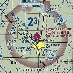
|
| Airport distance calculator |
|---|
|
|
| Sunrise and sunset |
|---|
|
Times for 09-Jul-2026
| | Local
(UTC-5) | | Zulu
(UTC) |
|---|
| Morning civil twilight | | 05:34 | | 10:34 |
| Sunrise | | 06:07 | | 11:07 |
| Sunset | | 20:58 | | 01:58 |
| Evening civil twilight | | 21:30 | | 02:30 |
|
| Current date and time |
|---|
| Zulu (UTC) | 09-Jul-2026 19:11:21 |
|---|
| Local (UTC-5) | 09-Jul-2026 14:11:21 |
|---|
|
| METAR |
|---|
| KBIE | 091855Z AUTO 32005KT 10SM CLR 30/21 A2991 RMK AO2 T02970211
|
|
| TAF |
|---|
KLNK
32nm N | 091720Z 0918/1018 02007KT P6SM SCT025 TEMPO 0918/0920 BKN025 FM092000 05006KT P6SM SCT050 FM100300 03003KT P6SM BKN120
|
|
| NOTAMs |
|---|
NOTAMs are issued by the DoD/FAA and will open in a separate window not controlled by AirNav.
|
|

