FAA INFORMATION EFFECTIVE 11 JUNE 2026
Location
| FAA Identifier: | BKX |
| Lat/Long: | 44-18-16.3000N 096-49-08.1000W
44-18.271667N 096-49.135000W
44.3045278,-96.8189167
(estimated) |
| Elevation: | 1647.5 ft. / 502.2 m (surveyed) |
| Variation: | 03E (2015) |
| Time zone: | UTC -5 (UTC -6 during Standard Time) |
| Zip code: | 57006 |
Airport Operations
| Airport use: | Open to the public |
| Activation date: | 11/1949 |
| Control tower: | no |
| ARTCC: | MINNEAPOLIS CENTER |
| FSS: | HURON FLIGHT SERVICE STATION |
| NOTAMs facility: | BKX (NOTAM-D service available) |
| Attendance: | 0800-1800 |
| Wind indicator: | lighted |
| Segmented circle: | no |
| Lights: | ACTVT MALSR RWY 12; REIL RWY 17, 30, 35; PAPI RWY 12, 17, 30, 35; HIRL RWY 12/30; MIRL RWY 17/35 - CTAF |
| Beacon: | white-green (lighted land airport)
Operates sunset to sunrise. |
Airport Communications
| CTAF/UNICOM: | 123.0 |
| WX AWOS-3PT: | 119.925 (605-979-7892) |
- APCH/DEP SVC PRVDD BY MINNEAPOLIS ARTCC (ZMP) ON FREQS 132.05/317.4 (SIOUX FALLS RCAG).
Nearby radio navigation aids
| VOR radial/distance | | VOR name | | Freq | | Var |
|---|
| FSDr349/39.3 | | SIOUX FALLS VORTAC | | 115.00 | | 09E |
| NDB name | | Hdg/Dist | | Freq | | Var | | ID |
|---|
| CHRLZ | | 116/6.3 | | 335 | | 03E | | BK | -... -.- |
Airport Services
| Fuel available: | 100LL JET-A |
| Parking: | hangars and tiedowns |
| Airframe service: | MAJOR |
| Powerplant service: | MAJOR |
| Bottled oxygen: | NONE |
| Bulk oxygen: | NONE |
Runway Information
Runway 12/30
| Dimensions: | 6000 x 100 ft. / 1829 x 30 m |
| Surface: | asphalt/grooved, in excellent condition |
| Weight bearing capacity: | | PCN 39 /F/D/X/T | | Single wheel: | 44.0 | | Double wheel: | 61.0 | | Double tandem: | 86.0 |
|
| Runway edge lights: | high intensity |
| RUNWAY 12 | | RUNWAY 30 |
| Latitude: | 44-18.484832N | | 44-18.013383N |
| Longitude: | 096-49.650318W | | 096-48.442070W |
| Elevation: | 1602.6 ft. | | 1636.7 ft. |
| Traffic pattern: | left | | left |
| Runway heading: | 116 magnetic, 119 true | | 296 magnetic, 299 true |
| Declared distances: | TORA:6000 TODA:6000 ASDA:6000 LDA:6000 | | TORA:6000 TODA:6000 ASDA:6000 LDA:6000 |
| Markings: | precision, in good condition | | precision, in good condition |
| Visual slope indicator: | 4-light PAPI on left (3.00 degrees glide path) | | 4-light PAPI on left (3.00 degrees glide path) |
| Approach lights: | MALSR: 1,400 foot medium intensity approach lighting system with runway alignment indicator lights | | |
| Runway end identifier lights: | | | yes |
| Touchdown point: | yes, no lights | | yes, no lights |
| Instrument approach: | ILS/DME | | |
Runway 17/35
| Dimensions: | 3600 x 60 ft. / 1097 x 18 m |
| Surface: | asphalt, in excellent condition |
| Weight bearing capacity: | | PCN 27 /F/D/X/T | | Single wheel: | 12.5 |
|
| Runway edge lights: | medium intensity |
| RUNWAY 17 | | RUNWAY 35 |
| Latitude: | 44-18.606083N | | 44-18.014483N |
| Longitude: | 096-49.304775W | | 096-49.259933W |
| Elevation: | 1609.8 ft. | | 1645.9 ft. |
| Traffic pattern: | left | | left |
| Runway heading: | 174 magnetic, 177 true | | 354 magnetic, 357 true |
| Declared distances: | TORA:3600 TODA:3600 ASDA:3600 LDA:3600 | | TORA:3600 TODA:3600 ASDA:3600 LDA:3600 |
| Markings: | nonprecision, in good condition | | nonprecision, in good condition |
| Visual slope indicator: | 2-light PAPI on left (3.00 degrees glide path) | | 2-light PAPI on left (3.00 degrees glide path) |
| Runway end identifier lights: | yes | | yes |
| Touchdown point: | yes, no lights | | yes, no lights |
Airport Ownership and Management from official FAA records
| Ownership: | Publicly-owned |
| Owner: | CITY OF BROOKINGS
520 3RD STREET, SUITE 140, PO BOX 270
BROOKINGS, SD 57006
Phone 605-692-6955 |
| Manager: | LUCAS DAHL
509 W SECOND STREET
BROOKINGS, SD 57006
Phone 605-697-8664 |
Additional Remarks
| - | INTENSIVE STUDENT TRAINING. |
| - | FOR CD IF UNA TO CTC ON FSS FREQ, CTC MINNEAPOLIS ARTCC AT 651-463-5588. |
| - | AIRFIELD CONDS NOT MNTD BTN 1900 - 0700 HRS LCL TIME. |
| - | RWY 30 IS PREFERRED RWY WHEN WNDS ARE CALM. |
| - | LARGE FLOCKS OF GEESE & GULLS ON & INVOF ARPT APR THRU OCT. |
| - | FOR ATTENDANT AFT HRS CALL 605-692-2779 OR 605-690-6013. |
| - | GCO AVBL ON FREQ 121.725 (4 CLICKS TO MINNEAPOLIS CENTER, 6 CLICKS TO FLT SVC) |
Instrument Procedures
NOTE: All procedures below are presented as PDF files. If you need a reader for these files, you should download the free Adobe Reader.NOT FOR NAVIGATION. Please procure official charts for flight.
FAA instrument procedures published for use from 11 June 2026 at 0901Z to 09 July 2026 at 0900z.
IAPs - Instrument Approach Procedures |
|---|
| ILS OR LOC RWY 12 | |
download (305KB) |
| RNAV (GPS) RWY 12 | |
download (242KB) |
| RNAV (GPS) RWY 30 | |
download (222KB) |
| NOTE: Special Alternate Minimums apply | |
download (99KB) |
| NOTE: Special Take-Off Minimums/Departure Procedures apply | |
download |
Other nearby airports with instrument procedures:
KMDS - Madison Municipal Airport (21 nm SW)
KPQN - Pipestone Municipal Airport (30 nm SE)
6E5 - Wilder Airport (33 nm W)
KCNB - Myers Field Airport (35 nm NE)
KATY - Watertown Regional Airport (39 nm N)
|
|

Road maps at:
MapQuest
Bing
Google
| Aerial photo |
|---|
WARNING: Photo may not be current or correct
 Photo taken 01-Apr-2017
looking south.
Photo taken 01-Apr-2017
looking south.
Do you have a better or more recent aerial photo of Brookings Regional Airport that you would like to share? If so, please send us your photo.
|
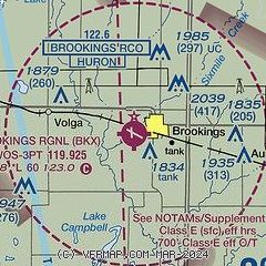
| Sectional chart |
|---|
|
| Airport distance calculator |
|---|
|
|
| Sunrise and sunset |
|---|
|
Times for 05-Jul-2026
| | Local
(UTC-5) | | Zulu
(UTC) |
|---|
| Morning civil twilight | | 05:14 | | 10:14 |
| Sunrise | | 05:51 | | 10:51 |
| Sunset | | 21:13 | | 02:13 |
| Evening civil twilight | | 21:49 | | 02:49 |
|
| Current date and time |
|---|
| Zulu (UTC) | 05-Jul-2026 11:26:14 |
|---|
| Local (UTC-5) | 05-Jul-2026 06:26:14 |
|---|
|
| METAR |
|---|
| KBKX | 051056Z AUTO VRB03KT 10SM CLR 18/16 A3006 RMK AO2 SLP178 T01780161
|
|
| TAF |
|---|
KATY
38nm N | 050520Z 0506/0606 15006KT P6SM SKC FM050900 00000KT 4SM BR FEW040 SCT050 FM051100 00000KT 3/4SM BR FEW050 SCT160 TEMPO 0511/0513 1/2SM FG FM051300 00000KT P6SM FEW045 SCT220 FM060000 12005KT P6SM FEW050 FEW250
|
KFSD
43nm S | 050539Z 0506/0606 VRB03KT P6SM SCT250 FM060000 11005KT P6SM FEW250
|
|
| NOTAMs |
|---|
NOTAMs are issued by the DoD/FAA and will open in a separate window not controlled by AirNav.
|
|

