FAA INFORMATION EFFECTIVE 19 MARCH 2026
Location
| FAA Identifier: | CSG |
| Lat/Long: | 32-30-58.7790N 084-56-19.9330W
32-30.979650N 084-56.332217W
32.5163275,-84.9388703
(estimated) |
| Elevation: | 397.7 ft. / 121.2 m (surveyed) |
| Variation: | 02W (1990) |
| From city: | 3 miles NE of COLUMBUS, GA |
| Time zone: | UTC -4 (UTC -5 during Standard Time) |
| Zip code: | 31909 |
Airport Operations
| Airport use: | Open to the public |
| Activation date: | 11/1942 |
| Control tower: | yes |
| ARTCC: | ATLANTA CENTER |
| FSS: | MACON FLIGHT SERVICE STATION |
| NOTAMs facility: | CSG (NOTAM-D service available) |
| Attendance: | CONTINUOUS |
| Wind indicator: | lighted |
| Segmented circle: | yes |
| Lights: | ALL LGTS OPER 0900-2100. AFTER 2100, ACTVT MALSR RWY 06; REIL RWY 24; PAPI RWY 06 & 24; HIRL RWY 06/24; MIRL RWY 13/31; TWY LGTS; WINDCONE LGTS - CTAF. REIL RWY 13 & 31; PAPI RWY 13 & 31 OPER CONSLY. |
| Beacon: | white-green (lighted land airport)
Operates sunset to sunrise. |
| Fire and rescue: | ARFF index A |
| Airline operations: | INDEX B ARFF EQUIP AVBL. |
Airport Communications
| CTAF: | 120.1 |
| UNICOM: | 122.95 |
| ATIS: | 127.75 |
| WX ASOS: | PHONE 706-748-8097 |
| COLUMBUS GROUND: | 121.9 348.6 [0900-2100] |
| COLUMBUS TOWER: | 120.1 257.8 [0900-2100] |
| ATLANTA APPROACH: | 125.5 126.55 ;7000 FT & ABV |
| ATLANTA DEPARTURE: | 125.5 126.55 ;7000 FT & ABV |
| EMERG: | 121.5 243.0 |
| WX AWOS-3PT at PIM (20 nm N): | 120.275 (706-663-2081) |
- APCH/DEP SVC PRVDD BY ATLANTA LARGE TRACON 0615-2200; APCH/DEP SVC PRVDD BY ATLANTA ARTCC APCH/DEP SVC 2200-0615 ON FREQS 120.45/298.850 (COLUMBUS RCAG).
Nearby radio navigation aids
| VOR radial/distance | | VOR name | | Freq | | Var |
|---|
| LSFr019/11.4 | | LAWSON VOR/DME | | 111.40 | | 05W |
| LGCr156/34.7 | | LAGRANGE VORTAC | | 115.60 | | 01E |
| EUFr014/35.3 | | EUFAULA VOR/DME | | 109.20 | | 02E |
| NDB name | | Hdg/Dist | | Freq | | Var | | ID |
|---|
| FENIX | | 055/6.5 | | 355 | | 02W | | CS | -.-. ... |
Airport Services
| Fuel available: | 100LL JET-A
100LL:SELF SERVE 100LL AVBL 24 HRS. |
| Parking: | hangars and tiedowns |
| Airframe service: | MAJOR |
| Powerplant service: | MAJOR |
| Bottled oxygen: | NONE |
| Bulk oxygen: | NONE |
Runway Information
Runway 6/24
| Dimensions: | 6997 x 150 ft. / 2133 x 46 m |
| Surface: | concrete/grooved, in excellent condition |
| Weight bearing capacity: | | Double wheel: | 160.0 | | Double tandem: | 250.0 |
|
| Runway edge lights: | high intensity |
| RUNWAY 6 | | RUNWAY 24 |
| Latitude: | 32-30.670002N | | 32-31.350727N |
| Longitude: | 084-56.719072W | | 084-55.619548W |
| Elevation: | 375.9 ft. | | 391.1 ft. |
| Traffic pattern: | left | | left |
| Runway heading: | 056 magnetic, 054 true | | 236 magnetic, 234 true |
| Declared distances: | TORA:6997 TODA:6997 ASDA:6997 LDA:6997 | | TORA:6997 TODA:6997 ASDA:6997 LDA:6997 |
| Markings: | precision, in good condition | | precision, in good condition |
| Visual slope indicator: | 4-light PAPI on left (2.61 degrees glide path) | | 4-light PAPI on left (3.00 degrees glide path) |
| RVR equipment: | touchdown | | |
| Approach lights: | MALSR: 1,400 foot medium intensity approach lighting system with runway alignment indicator lights | | |
| Runway end identifier lights: | | | yes |
| Touchdown point: | yes, no lights | | yes, no lights |
| Instrument approach: | ILS | | |
| Obstructions: | 79 ft. trees, 2450 ft. from runway, 250 ft. left of centerline, 28:1 slope to clear | | 29 ft. bldg, lighted, 690 ft. from runway, 275 ft. right of centerline, 16:1 slope to clear
+5 FT GND 200 FT FROM RWY END 500 FT RIGHT. |
Runway 13/31
| Dimensions: | 3997 x 75 ft. / 1218 x 23 m |
| Surface: | asphalt, in good condition |
| Weight bearing capacity: | | Single wheel: | 24.0 | | Double wheel: | 44.0 |
|
| Runway edge lights: | medium intensity |
| Operational restrictions: | RWY 13/31 NOT AVBL FOR PART 121/PART 380 OPS WITH SKED PAX CARRYING OPS MORE THAN 9 PAX SEATS AND NON-SKED PAX CARRYING OPS MORE THAN 30 PAX SEATS. |
| RUNWAY 13 | | RUNWAY 31 |
| Latitude: | 32-31.124195N | | 32-30.727463N |
| Longitude: | 084-56.927943W | | 084-56.306720W |
| Elevation: | 397.7 ft. | | 369.4 ft. |
| Traffic pattern: | left | | left |
| Runway heading: | 129 magnetic, 127 true | | 309 magnetic, 307 true |
| Displaced threshold: | no | | 150 ft. |
| Declared distances: | TORA:3997 TODA:3997 ASDA:3907 LDA:3907 | | TORA:3997 TODA:3997 ASDA:3997 LDA:3847 |
| Markings: | nonprecision, in good condition | | basic, in good condition |
| Visual slope indicator: | 4-light PAPI on left (3.00 degrees glide path) | | 4-light PAPI on left (3.00 degrees glide path) |
| Runway end identifier lights: | yes | | yes |
| Touchdown point: | yes, no lights | | yes, no lights |
| Obstructions: | 72 ft. tree, 1300 ft. from runway, 250 ft. left of centerline, 15:1 slope to clear | | 10 ft. pole, lighted, 300 ft. from runway, 50 ft. left of centerline, 10:1 slope to clear |
Airport Ownership and Management from official FAA records
| Ownership: | Publicly-owned |
| Owner: | COLUMBUS AIRPORT COMMISSION
3250 W BRITT DAVID RD
COLUMBUS, GA 31909
Phone 706-324-2449 |
| Manager: | AMBER CLARK, A.A.E.
3250 W BRITT DAVID RD
COLUMBUS, GA 31909
Phone 706-575-0907 |
Additional Remarks
| A39-06/24 | PCR VALUE: 458/F/C/X/T |
| A39-13/31 | PCR VALUE: 75/F/B/X/T |
| - | BIRDS ON & INVOF ARPT. |
| - | FOR CD IF UNA TO CTC ON FSS FREQ, CTC ATLANTA APCH AT 678-364-6132, WHEN ATCT CLSD CTC ATLANTA ARTCC AT 770-210-7692. |
| - | BE ALERT FOR RWY 6 AT TWY D INT DEP INSTRUCTIONS WITH RWY RMNG 5085 FT TORA/TODA/ASDA. |
| - | BE ALERT FOR RWY 6 AT TWY F INT DEP INSTRUCTIONS WITH RWY RMNG 5623 FT TORA/TODA/ASDA. |
Instrument Procedures
NOTE: All procedures below are presented as PDF files. If you need a reader for these files, you should download the free Adobe Reader.NOT FOR NAVIGATION. Please procure official charts for flight.
FAA instrument procedures published for use from 19 March 2026 at 0901Z to 16 April 2026 at 0900Z.
IAPs - Instrument Approach Procedures |
|---|
| ILS OR LOC RWY 06 | |
download (257KB) |
| RNAV (GPS) RWY 06 | |
download (298KB) |
| RNAV (GPS) RWY 13 | |
download (225KB) |
| RNAV (GPS) RWY 24 | |
download (254KB) |
| NOTE: Special Alternate Minimums apply | |
download (158KB) |
| NOTE: Special Take-Off Minimums/Departure Procedures apply | |
download (491KB) |
Other nearby airports with instrument procedures:
KLSF - Lawson Army Airfield (Fort Benning) (11 nm S)
KPIM - Harris County Airport (20 nm N)
7A3 - Lanett Regional Airport (23 nm NW)
KAUO - Auburn University Regional Airport (26 nm W)
KLGC - LaGrange-Callaway Airport (30 nm N)
|
|

Road maps at:
MapQuest
Bing
Google
| Aerial photo |
|---|
WARNING: Photo may not be current or correct
 Photo by Don Neuberg
Photo taken 24-Feb-2017
looking east.
Photo by Don Neuberg
Photo taken 24-Feb-2017
looking east.
Do you have a better or more recent aerial photo of Columbus Airport that you would like to share? If so, please send us your photo.
|
| Sectional chart |
|---|
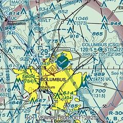
|
 Download PDF
of official airport diagram from the FAA
| Airport distance calculator |
|---|
|
|
| Sunrise and sunset |
|---|
|
Times for 07-Apr-2026
| | Local
(UTC-4) | | Zulu
(UTC) |
|---|
| Morning civil twilight | | 06:56 | | 10:56 |
| Sunrise | | 07:21 | | 11:21 |
| Sunset | | 20:03 | | 00:03 |
| Evening civil twilight | | 20:28 | | 00:28 |
|
| Current date and time |
|---|
| Zulu (UTC) | 08-Apr-2026 03:45:18 |
|---|
| Local (UTC-4) | 07-Apr-2026 23:45:18 |
|---|
|
| METAR |
|---|
| KCSG | 080251Z AUTO 00000KT 10SM CLR 17/06 A3016 RMK AO2 SLP210 T01720056 53018
|
KLSF
12nm S | 080255Z AUTO 00000KT 10SM CLR 12/08 A3013 RMK AO2 SLP208 T01180079 52017 $
|
KPIM
20nm N | 080335Z AUTO 04003KT 10SM FEW029 BKN040 BKN060 12/10 A3019 RMK AO2
|
|
| TAF |
|---|
| KCSG | 071734Z 0718/0818 08010G18KT P6SM FEW200 FM080200 06006KT P6SM FEW250 FM081000 07010KT P6SM SKC FM081500 07012G22KT P6SM FEW200
|
KLSF
12nm S | 071300Z 0713/0819 03006KT 9999 FEW250 510105 QNH3012INS BECMG 0717/0718 03012G20KT 9999 FEW250 520105 QNH3007INS BECMG 0801/0802 05005KT 9999 SKC QNH3009INS BECMG 0815/0816 08015G25KT 9999 FEW250 510006 QNH3022INS TX26/0721Z TN07/0812Z
|
|
| NOTAMs |
|---|
NOTAMs are issued by the DoD/FAA and will open in a separate window not controlled by AirNav.
|
|


