FAA INFORMATION EFFECTIVE 30 OCTOBER 2025
Location
| FAA Identifier: | DGL |
| Lat/Long: | 31-20-33.3700N 109-30-23.2360W
31-20.556167N 109-30.387267W
31.3426028,-109.5064544
(estimated) |
| Elevation: | 4173 ft. / 1271.9 m (surveyed) |
| Variation: | 12E (1985) |
| From city: | 2 miles E of DOUGLAS, AZ |
| Time zone: | UTC -7 (year round; does not observe DST) |
| Zip code: | 85607 |
Airport Operations
| Airport use: | Open to the public |
| Activation date: | 04/1940 |
| Control tower: | no |
| ARTCC: | ALBUQUERQUE CENTER |
| FSS: | PRESCOTT FLIGHT SERVICE STATION |
| NOTAMs facility: | PRC (NOTAM-D service available) |
| Attendance: | MON-FRI 0600-1400
FOR SVC AFT HRS CALL 520-368-6015. |
| Wind indicator: | lighted |
| Segmented circle: | yes |
| Lights: | DUSK-DAWN. PAPI RWYS 03 AND 21 OTS INDFLY. |
| Beacon: | white-green (lighted land airport)
Operates sunset to sunrise. |
| International operations: | international airport of entry |
Airport Communications
| CTAF/UNICOM: | 122.8 |
| WX ASOS at DUG (9 nm NW): | 119.275 (520-364-7208) |
| WX AWOS-2 at P03 (10 nm W): | 119.925 (520-417-4114) |
- COMMUNICATIONS PRVDD BY PRESCOTT RADIO ON FREQ 122.6 (DOUGLAS RCO).
Nearby radio navigation aids
| VOR radial/distance | | VOR name | | Freq | | Var |
|---|
| DUGr135/9.2 | | DOUGLAS VORTAC | | 108.80 | | 13E |
Airport Services
| Fuel available: | 100LL JET-A
100LL:24 HOUR 100LL AVAILABLE WITH MAJOR CREDIT CARD. |
| Parking: | hangars and tiedowns |
| Bottled oxygen: | NONE |
| Bulk oxygen: | NONE |
Runway Information
Runway 3/21
| Dimensions: | 5760 x 75 ft. / 1756 x 23 m |
| Surface: | asphalt, in fair condition
RY HAS 1-6 INCH CRACKS ACROSS RY. |
| Runway edge lights: | medium intensity |
| RUNWAY 3 | | RUNWAY 21 |
| Latitude: | 31-20.172000N | | 31-20.889667N |
| Longitude: | 109-30.620833W | | 109-29.895000W |
| Traffic pattern: | right | | left |
| Markings: | basic, in good condition | | basic, in good condition |
| Visual slope indicator: | 4-light PAPI on left (4.00 degrees glide path)
PAPI OTS INDEFLY. | | 4-light PAPI on left (4.00 degrees glide path)
PAPI OTS INDEF. |
| Runway end identifier lights: | no | | no |
| Obstructions: | 7 ft. brush, 260 ft. from runway, 10 ft. right of centerline, 8:1 slope to clear
RWY 03, 3-8 FT BRUSH 0-200 FT FM THR, 45-125 FT LEFT AND RIGHT OF CNTRLN. | | 8 ft. brush, 201 ft. from runway, 45 ft. right of centerline
RWY 21, 2-6 FT BRUSH 0-200 FT FM THR, 30-125 FT LEFT AND RIGHT OF CNTRLN. |
Runway 18/36
| Dimensions: | 4095 x 100 ft. / 1248 x 30 m |
| Surface: | dirt, in poor condition
RY HAS +4 FT BRUSH, ROCKS & UNEVEN SURFACE FOR 3/4 OF RY LENGTH. |
| Operational restrictions: | RY CLSD INDEFLY. |
| RUNWAY 18 | | RUNWAY 36 |
| Traffic pattern: | left | | right |
| Runway end identifier lights: | no | | no |
| Obstructions: | 6 ft. brush | | 6 ft. brush |
Airport Ownership and Management from official FAA records
| Ownership: | Publicly-owned |
| Owner: | CITY OF DOUGLAS
425 10TH STREET
DOUGLAS, AZ 85607
Phone 520-417-7329 |
| Manager: | MAX TAPIA
425 E. 10TH STREET
DOUGLAS, AZ 85607
Phone (520) 368-6015
ALTERNATE ALEXANDRO TERAN, 520--368-6015. |
Additional Remarks
| - | MTNS 1 1/2 MILES EAST. |
| - | FLIGHT NOTIFICATION SVC AVBL. |
| - | RWY 18/36 BRUSH ON BOTH SIDES 70 FT FM CNTRLN FULL LENGTH OF RWY. |
| - | RWY 18/36 +3 FT BUMP 300 FT FROM RWY 18 THLD. |
| - | RWY 18/36 2 FT BUMP CROSSING TXY TO RWY 03/21. |
| - | PERSONNEL ON ATVS NEAR AIRCRAFT OPERATING AREAS - UNRESTRICTED. |
| - | RWY 03/21, 4-6 FT BRUSH IN PRIMARY SURFACE AS CLOSE AS 30 FT FM CNTRLN. |
Instrument Procedures
There are no published instrument procedures at KDGL.
Some nearby airports with instrument procedures:
KDUG - Bisbee Douglas International Airport (9 nm NW)
KFHU - Sierra Vista Municipal Airport-Libby Army Airfield (45 nm W)
P33 - Cochise County Airport (58 nm N)
KOLS - Nogales International Airport (69 nm W)
KDMA - Davis Monthan Air Force Base (86 nm NW)
|
|

Road maps at:
MapQuest
Bing
Google
| Aerial photo |
|---|
WARNING: Photo may not be current or correct

Do you have a better or more recent aerial photo of Douglas Municipal Airport that you would like to share? If so, please send us your photo.
|
| Sectional chart |
|---|
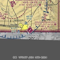
|
| Airport distance calculator |
|---|
|
|
| Sunrise and sunset |
|---|
|
Times for 22-Nov-2025
| | Local
(UTC-7) | | Zulu
(UTC) |
|---|
| Morning civil twilight | | 06:27 | | 13:27 |
| Sunrise | | 06:53 | | 13:53 |
| Sunset | | 17:16 | | 00:16 |
| Evening civil twilight | | 17:42 | | 00:42 |
|
| Current date and time |
|---|
| Zulu (UTC) | 22-Nov-2025 19:08:26 |
|---|
| Local (UTC-7) | 22-Nov-2025 12:08:26 |
|---|
|
| TAF |
|---|
KDUG
8nm NW | 221720Z 2218/2318 11011G18KT P6SM SCT100 FM222000 15015G25KT P6SM BKN060 FM230200 17009KT P6SM VCSH BKN040 BKN070 FM230300 17009KT P6SM -SHRA VCTS BKN030CB BKN050 TEMPO 2303/2307 VRB25G40KT 4SM -TSRA BKN030CB FM231300 14009KT P6SM VCSH BKN050 BKN060 FM231600 20007KT P6SM BKN060 AMD NOT SKED
|
|
| NOTAMs |
|---|
NOTAMs are issued by the DoD/FAA and will open in a separate window not controlled by AirNav.
|
|


