FAA INFORMATION EFFECTIVE 09 JULY 2026
Location
| FAA Identifier: | FIN |
| Lat/Long: | 29-27-54.5440N 081-12-27.5340W
29-27.909067N 081-12.458900W
29.4651511,-81.2076483
(estimated) |
| Elevation: | 33.1 ft. / 10.1 m (surveyed) |
| Variation: | 06W (2005) |
| From city: | 6 miles S of PALM COAST, FL |
| Time zone: | UTC -4 (UTC -5 during Standard Time) |
| Zip code: | 32164 |
Airport Operations
| Airport use: | Open to the public |
| Activation date: | 08/1945 |
| Control tower: | yes |
| ARTCC: | JACKSONVILLE CENTER |
| FSS: | GAINESVILLE FLIGHT SERVICE STATION |
| NOTAMs facility: | FIN (NOTAM-D service available) |
| Attendance: | MON-SAT 0700-1800, ALL SUN 0800-1500 |
| Wind indicator: | lighted |
| Segmented circle: | yes |
| Lights: | WHEN ATCT CLSD, ACTVT REIL RWY 6, 11, 24, & 29; PAPI RWY 6, 24, 11 & 29; MIRL RWYS 6/24 & 11/29 - CTAF. |
| Beacon: | white-green (lighted land airport)
Operates sunset to sunrise. |
Airport Communications
| CTAF: | 118.95 |
| UNICOM: | 123.0 |
| ATIS: | 128.325 |
| WX AWOS-3: | 128.325 (386-437-7334) |
| FLAGLER TOWER GROUND: | 121.75 [0600-2000] |
| FLAGLER TOWER TOWER: | 118.95 [0600-2000] |
| DAYTONA APPROACH: | 125.8 |
| DAYTONA DEPARTURE: | 125.8 |
| CLEARANCE DELIVERY: | 121.75 |
| WX AWOS-3 at OMN (11 nm SE): | 118.475 (386-615-7084) |
| WX ASOS at DAB (19 nm SE): | PHONE 386-232-5134 |
Nearby radio navigation aids
| VOR radial/distance | | VOR name | | Freq | | Var |
|---|
| OMNr333/10.9 | | ORMOND BEACH VORTAC | | 112.60 | | 00E |
| NDB name | | Hdg/Dist | | Freq | | Var | | ID |
|---|
| REYNOLDS | | 149/38.2 | | 338 | | 07W | | RYD | .-. -.-- -.. |
Airport Services
| Fuel available: | 100LL JET-A
A:FOR JET A FUEL AFTER HRS CALL 386-313-4220 24 HRS IN ADVANCE. FUEL NOT AVBL AT LAKE. |
| Parking: | tiedowns |
| Airframe service: | MAJOR |
| Powerplant service: | MAJOR |
| Bottled oxygen: | NONE |
| Bulk oxygen: | NONE |
Runway Information
Runway 11/29
| Dimensions: | 5500 x 100 ft. / 1676 x 30 m |
| Surface: | asphalt/grooved, in good condition |
| Weight bearing capacity: | | PCN 27 /F/A/X/T | | Single wheel: | 60.0 |
|
| Runway edge lights: | medium intensity |
| RUNWAY 11 | | RUNWAY 29 |
| Latitude: | 29-28.219522N | | 29-27.975223N |
| Longitude: | 081-12.764343W | | 081-11.765625W |
| Elevation: | 30.8 ft. | | 30.9 ft. |
| Traffic pattern: | left
RWY 11 DSGND CALM WIND RWY FOR ARRS AND DEPS 0300-1100Z. | | left |
| Runway heading: | 112 magnetic, 106 true | | 292 magnetic, 286 true |
| Markings: | nonprecision, in fair condition | | nonprecision, in fair condition |
| Visual slope indicator: | 4-light PAPI on left (3.00 degrees glide path) | | 4-light PAPI on left (3.00 degrees glide path) |
| Runway end identifier lights: | yes | | yes |
| Touchdown point: | yes, no lights | | yes, no lights |
| Obstructions: | 55 ft. trees, 2155 ft. from runway, 250 ft. right of centerline, 35:1 slope to clear
APRCH SLP 34:1 TO AER. | | 69 ft. trees, 2324 ft. from runway, 250 ft. right of centerline, 30:1 slope to clear |
Runway 6/24
| Dimensions: | 5001 x 100 ft. / 1524 x 30 m |
| Surface: | asphalt/grooved, in excellent condition |
| Weight bearing capacity: | | PCN 19 /F/B/Y/T | | Single wheel: | 60.0 |
|
| Runway edge lights: | medium intensity |
| RUNWAY 6 | | RUNWAY 24 |
| Latitude: | 29-27.644380N | | 29-28.123347N |
| Longitude: | 081-12.732583W | | 081-11.964947W |
| Elevation: | 29.6 ft. | | 31.0 ft. |
| Traffic pattern: | left | | left |
| Runway heading: | 061 magnetic, 055 true | | 241 magnetic, 235 true |
| Markings: | nonprecision, in fair condition | | nonprecision, in fair condition |
| Visual slope indicator: | 4-light PAPI on left (3.00 degrees glide path) | | 4-light PAPI on left (3.00 degrees glide path) |
| Runway end identifier lights: | yes | | yes |
| Touchdown point: | yes, no lights | | yes, no lights |
| Obstructions: | 84 ft. trees, 3075 ft. from runway, 315 ft. right of centerline, 34:1 slope to clear | | 56 ft. trees, 1325 ft. from runway, 130 ft. left of centerline, 20:1 slope to clear |
Helipad H1
| Dimensions: | 36 x 36 ft. / 11 x 11 m |
| Surface: | concrete/gravel, in fair condition |
| Operational restrictions: | HELIPAD NA EXC FLAGLER COUNTY EMERG SVCS. |
| Latitude: | 29-28.381000N | | |
| Longitude: | 081-12.522500W | | |
| Elevation: | 31.0 ft. | | |
| Traffic pattern: | left | | left |
Runway 18W/36W
| Dimensions: | 3001 x 500 ft. / 915 x 152 m |
| Surface: | water |
| Operational restrictions: | SEAPLANE LNDG AREA GORE LAKE 3196 FT BY 1633 FT UNMRKD; 40 FT TREES WATER EDGE ALL QUADRANTS; ALL APCHS HDG 180 DEG OR 360 DEG PAST TREES. |
| RUNWAY 18W | | RUNWAY 36W |
| Latitude: | 29-27.851357N | | 29-27.360420N |
| Longitude: | 081-13.034430W | | 081-12.961260W |
| Elevation: | 22.0 ft. | | 22.0 ft. |
| Traffic pattern: | left | | left |
| Runway heading: | 179 magnetic, 173 true | | 359 magnetic, 353 true |
| Touchdown point: | yes, no lights | | yes, no lights |
Airport Ownership and Management from official FAA records
| Ownership: | Publicly-owned |
| Owner: | FLAGLER COUNTY
1769 EAST MOODY BOULEVARD, #2, SUITE 302
BUNNELL, FL 32110
Phone 386-313-4125 |
| Manager: | ROY SIEGER
201 AIRPORT ROAD
PALM COAST, FL 32164
Phone 386-313-4220
386-313-4220 |
Additional Remarks
| A30A-24 | UNLGTD OBSTNS IN APCH; 1080 FT TREES BFR AER. |
| - | NOISE ABATEMENT PROCS IN EFCT, VOLUNTARY RESTRAINT FROM TGL OPS 0300-1200Z. |
| - | TWY B BTN TWY A1 & D CLSD TO FIXED WING ACFT. |
| - | FOR CD OR TO CNL IFR WHEN ATCT IS CLSD CTC DAB APCH AT 386-226-3939. |
| - | HEL OPS CONDUCTED WI ARPT BNDRY 500 FT OR BLW UNLESS DRCTD BY ATC; HEL OPS RWY 06 & 29 LEFT TFC; HEL OPS RWY 11 & 24 RIGHT TFC. |
| - | NOISE SENSITIVE AREA ALL QUADS OF THE ARPT. |
Instrument Procedures
NOTE: All procedures below are presented as PDF files. If you need a reader for these files, you should download the free Adobe Reader.NOT FOR NAVIGATION. Please procure official charts for flight.
FAA instrument procedures published for use from 09 July 2026 at 0901Z to 06 August 2026 at 0900Z.
IAPs - Instrument Approach Procedures |
|---|
| RNAV (GPS) RWY 06 | |
download (244KB) |
| RNAV (GPS) RWY 11 | |
download (236KB) |
| RNAV (GPS) RWY 24 | |
download (227KB) |
| RNAV (GPS) RWY 29 | |
download (229KB) |
| NOTE: Special Alternate Minimums apply | |
download (146KB) |
| NOTE: Special Take-Off Minimums/Departure Procedures apply | |
download (408KB) |
Other nearby airports with instrument procedures:
KOMN - Ormond Beach Municipal Airport (11 nm SE)
KDAB - Daytona Beach International Airport (19 nm SE)
KDED - DeLand Municipal Airport-Sidney H Taylor Field (24 nm S)
7FL6 - Spruce Creek Airport (25 nm S)
28J - Palatka Municipal Airport/Lt. Kay Larkin Field (28 nm NW)
|
|

Road maps at:
MapQuest
Bing
Google
| Aerial photo |
|---|
WARNING: Photo may not be current or correct
 Photo by Jim Russell
Russell Aerial Photography Inc
Photo taken 07-Mar-2019
looking west.
Do you have a better or more recent aerial photo of Flagler Executive Airport that you would like to share? If so, please send us your photo.
|
| Sectional chart |
|---|
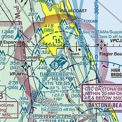
|
| Airport distance calculator |
|---|
|
|
| Sunrise and sunset |
|---|
|
Times for 03-Aug-2026
| | Local
(UTC-4) | | Zulu
(UTC) |
|---|
| Morning civil twilight | | 06:21 | | 10:21 |
| Sunrise | | 06:47 | | 10:47 |
| Sunset | | 20:15 | | 00:15 |
| Evening civil twilight | | 20:41 | | 00:41 |
|
| Current date and time |
|---|
| Zulu (UTC) | 03-Aug-2026 18:43:47 |
|---|
| Local (UTC-4) | 03-Aug-2026 14:43:47 |
|---|
|
| METAR |
|---|
| KFIN | 031150Z 20005KT 10SM CLR 24/23 A2994
|
KOMN
11nm SE | 031750Z 24008KT 7SM CLR 30/26 A2993
|
KDAB
18nm SE | 031753Z 24011KT 10SM FEW035 BKN130 BKN250 29/24 A2994 RMK AO2 RAE06 SLP137 P0000 60000 T02940239 10294 20250 58005
|
|
| TAF |
|---|
KDAB
18nm SE | 031720Z 0318/0418 24012G20KT P6SM VCSH SCT035 BKN100 BKN150 FM032200 23009KT P6SM VCSH SCT025 BKN080 FM040200 19003KT P6SM SCT030 BKN180 FM041400 23007KT P6SM FEW030 BKN140
|
|
| NOTAMs |
|---|
NOTAMs are issued by the DoD/FAA and will open in a separate window not controlled by AirNav.
|
|


