FAA INFORMATION EFFECTIVE 14 MAY 2026
Location
| FAA Identifier: | FOE |
| Lat/Long: | 38-57-03.4170N 095-39-49.0090W
38-57.056950N 095-39.816817W
38.9509492,-95.6636136
(estimated) |
| Elevation: | 1077.9 ft. / 328.5 m (surveyed) |
| Variation: | 05E (1990) |
| From city: | 6 miles S of TOPEKA, KS |
| Time zone: | UTC -5 (UTC -6 during Standard Time) |
| Zip code: | 66619 |
Airport Operations
| Airport use: | Open to the public |
| Activation date: | 02/1944 |
| Control tower: | yes |
| ARTCC: | KANSAS CITY CENTER |
| FSS: | WICHITA FLIGHT SERVICE STATION |
| NOTAMs facility: | FOE (NOTAM-D service available) |
| Attendance: | 0545-2200
MIL USE: SEE FLIP AP/1 SUPPLEMENTARY ARPT RMK. |
| Wind indicator: | lighted |
| Segmented circle: | no |
| Lights: | WHEN ATCT CLSD ACTVT MALSF RWY 13; MALSR RWY 31; MIRL RWY 03/21; HIRL RWY 13/31 - CTAF. VASI RWY 03; PAPI RWY 13, 21 & 31; OPR CONSLY. |
| Beacon: | white-white-green (lighted military airport)
Operates sunset to sunrise. |
| Fire and rescue: | ARFF index A |
| Airline operations: | 24 HR PPR FOR UNSKED ACR OPS GTR THAN 30 PAX SEATS - AMGR. ARFF INDEX B AVBL; ARFF INDEX C LEVEL EQUIP AVBL UPON REQ. |
Airport Communications
| CTAF: | 120.8 |
| UNICOM: | 122.95 |
| ATIS: | 128.25 |
| WX ASOS: | PHONE 785-862-8258 |
| FORBES GROUND: | 118.425 275.8 [0545-2200] |
| FORBES TOWER: | 120.8 340.2 236.6 [0545-2200] |
| ANG OPS: | 255.5 |
| ARNG OPS: | 141.9 238.25 38.5 |
| EMERG: | 121.5 243.0 |
| WX ASOS at TOP (7 nm N): | 121.275 (785-274-8258) |
- APCH/DEP CTL SVC PRVDD BY KANSAS CITY ARTCC (ZKC) ON FREQS 123.8/343.7 (TOPEKA RCAG).
Nearby radio navigation aids
| VOR radial/distance | | VOR name | | Freq | | Var |
|---|
| TOPr201/12.4 | | TOPEKA VORTAC | | 117.80 | | 05E |
| NDB name | | Hdg/Dist | | Freq | | Var | | ID |
|---|
| BILOY | | 169/10.2 | | 521 | | 05E | | TO | - --- |
Airport Services
| Fuel available: | 100LL JET-A |
| Parking: | hangars and tiedowns |
| Airframe service: | MAJOR |
| Powerplant service: | MAJOR |
Runway Information
Runway 13/31
| Dimensions: | 12803 x 150 ft. / 3902 x 46 m |
| Surface: | concrete/grooved, in excellent condition |
| Weight bearing capacity: | | Single wheel: | 120.0 | | Double wheel: | 250.0 | | Double tandem: | 550.0 | | Dual double tandem: | 1119.0 |
|
| Runway edge lights: | high intensity |
| RUNWAY 13 | | RUNWAY 31 |
| Latitude: | 38-57.933500N | | 38-56.389855N |
| Longitude: | 095-40.682995W | | 095-38.842605W |
| Elevation: | 1063.1 ft. | | 1035.9 ft. |
| Traffic pattern: | right | | left |
| Runway heading: | 132 magnetic, 137 true | | 312 magnetic, 317 true |
| Declared distances: | TORA:12803 TODA:12803 ASDA:12803 LDA:12803 | | TORA:12803 TODA:12803 ASDA:12803 LDA:12803 |
| Markings: | precision, in fair condition | | precision, in fair condition |
| Visual slope indicator: | 4-light PAPI on left (3.00 degrees glide path) | | 4-light PAPI on left (3.00 degrees glide path) |
| RVR equipment: | rollout | | touchdown |
| Approach lights: | MALSF: 1,400 foot medium intensity approach lighting system with sequenced flashers | | MALSR: 1,400 foot medium intensity approach lighting system with runway alignment indicator lights |
| Runway end identifier lights: | yes
OTS. | | |
| Touchdown point: | yes, no lights | | yes, no lights |
| Instrument approach: | | | ILS/DME |
| Obstructions: | 35 ft. tree, 1750 ft. from runway, 300 ft. left of centerline, 44:1 slope to clear | | 59 ft. tree, 2900 ft. from runway, 500 ft. left of centerline, 45:1 slope to clear |
Runway 3/21
| Dimensions: | 7002 x 150 ft. / 2134 x 46 m |
| Surface: | asphalt/grooved, in excellent condition |
| Weight bearing capacity: | | Single wheel: | 120.0 | | Double wheel: | 250.0 | | Double tandem: | 550.0 | | Dual double tandem: | 1120.0 |
|
| Runway edge lights: | medium intensity |
| RUNWAY 3 | | RUNWAY 21 |
| Latitude: | 38-56.422407N | | 38-57.308243N |
| Longitude: | 095-40.388770W | | 095-39.442948W |
| Elevation: | 1077.9 ft. | | 1043.2 ft. |
| Traffic pattern: | right | | left |
| Runway heading: | 035 magnetic, 040 true | | 215 magnetic, 220 true |
| Declared distances: | TORA:7001 TODA:7001 ASDA:7001 LDA:7001 | | TORA:7001 TODA:7001 ASDA:7001 LDA:7001 |
| Markings: | nonprecision, in good condition | | nonprecision, in good condition |
| Visual slope indicator: | 4-box VASI on left (3.00 degrees glide path) | | 4-light PAPI on left (3.00 degrees glide path) |
| Runway end identifier lights: | yes | | yes |
| Touchdown point: | yes, no lights | | yes, no lights |
| Obstructions: | none | | 36 ft. tree, 1850 ft. from runway, 200 ft. right of centerline, 45:1 slope to clear |
Airport Ownership and Management from official FAA records
| Ownership: | Publicly-owned |
| Owner: | METROPOLITAN TOPEKA ARPT AUTH
6510 SE FORBES AVE #1
TOPEKA, KS 66619
Phone 785-862-2362 |
| Manager: | MR ERIC M JOHNSON
6510 SE FORBES AVE #1
TOPEKA, KS 66619
Phone 785-862-2362 |
Additional Remarks
| A39-13/31 | PCR VALUE: 1210/R/D/W/T |
| A39-03/21 | PCR VALUE: 2200/F/D/X/T |
| E110 | OPERS ARPT LGTG ONLY. |
| - | JASU: 14(A/M32A-86D) 11(A/M32A-95) |
| - | FUEL: A+ MILLION AIRTOPEKA 1200-0400Z++ - C785-862-0950; OTR TIMES 3 HR PPR - C785-862-6104/785-224-2899. A++ MIL. |
| - | FLUID: ADI SP LPOX LOX OIL - O-128-148(MIL) - AVBL ONLY IN QT CANS. |
| - | CTN: DO NOT MISTAKE PHILIP BILLARD MUNI 7 NM N FOR TOPEKA RGNL. |
| - | NOISE ABATEMENT PROC: VFR TFC AVOID OVFT OF HOUSING AREA 2 NM W RWY 13. |
| - | ANG: RAMP & SVC 72 HR PPR - C785-861-4655/4663. ANG RAMP PRKG - WYLIE CON 20 MIN BFR LDG. ADZ ARR & DEP - 255.5. AIRFIELD MGMT, MOC & POL 1330-2200Z++; CLSD WKEND & FED HOL; AFT HR PPR. |
| - | ANG: FLEET SVC, OIL SOAP SAMPLING & DRAG CHUTE REPACK NA. PRECISION MEASURING EQPT LAB PUP & DLVR EXP 1.5 HR DLA. TSNT SVC & DEICING AVBL AT FBO. TSNT MAINT & PARTS SVC EXC KC-135R LTD. NO QTRS AVBL. |
| - | TFC PTN: 1000 FT AGL FOR LGT (SLOW) ACFT & 1500 FT FOR HEAVY (FAST) ACFT. |
| - | ARNG - OPR 1300-2300Z++ TUE-FRI EXC HOL, OCNL SAT, SUN. LTD MAINT UH-60. TRAN ARMY ACFT CTC C785-646-3825. ARMY ACFT CTC TOPEKA GUARD OPS 38.50 OR 238.250. OPS C785-646-3825 OR 3827. RAMP AND FAC W OF RWY 03 APCH END OF RWY. |
| - | F/W & R/W RAPID REFUEL 0600-2200 - 785-862-0950. 24 HR PN & ARINC BFR LNDG - 129.85. ADZ ATC FOR RAPID REFUEL OPS & PROC TO N RAMP. 5 ACFT SIMUL OPS AVBL. |
| - | BIRDS ON & INVOF ARPT. BIRD HAZ PHASE II APR-MAY & AUG-OCT. |
Instrument Procedures
NOTE: All procedures below are presented as PDF files. If you need a reader for these files, you should download the free Adobe Reader.NOT FOR NAVIGATION. Please procure official charts for flight.
FAA instrument procedures published for use from 14 May 2026 at 0901Z to 11 June 2026 at 0900Z.
IAPs - Instrument Approach Procedures |
|---|
| ILS OR LOC RWY 31 | |
download (259KB) |
| RNAV (GPS) RWY 03 | |
download (261KB) |
| RNAV (GPS) RWY 13 | |
download (271KB) |
| RNAV (GPS) RWY 21 | |
download (270KB) |
| RNAV (GPS) RWY 31 | |
download (253KB) |
| VOR/DME OR TACAN RWY 03 | |
download (203KB) |
| VOR/DME OR TACAN RWY 21 | |
download (195KB) |
| HI-TACAN RWY 13 | |
download (130KB) |
| HI-TACAN RWY 31 | |
download (133KB) |
| TACAN RWY 13 | |
download (213KB) |
| TACAN RWY 31 | |
download (224KB) |
| NOTE: Special Alternate Minimums apply | |
download (147KB) |
| NOTE: Special Take-Off Minimums/Departure Procedures apply | |
download (187KB) |
Other nearby airports with instrument procedures:
KTOP - Philip Billard Municipal Airport (7 nm N)
KLWC - Lawrence Regional Airport (21 nm E)
KOWI - Ottawa Municipal Airport (31 nm SE)
KIXD - New Century AirCenter Airport (37 nm E)
KUKL - Coffey County Airport (39 nm S)
|
|

Road maps at:
MapQuest
Bing
Google
| Aerial photo |
|---|
WARNING: Photo may not be current or correct

Do you have a better or more recent aerial photo of Topeka Regional Airport that you would like to share? If so, please send us your photo.
|
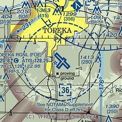
| Sectional chart |
|---|
|
CAUTION: Diagram may not be current
 Download PDF
of official airport diagram from the FAA
| Airport distance calculator |
|---|
|
|
| Sunrise and sunset |
|---|
|
Times for 19-May-2026
| | Local
(UTC-5) | | Zulu
(UTC) |
|---|
| Morning civil twilight | | 05:37 | | 10:37 |
| Sunrise | | 06:08 | | 11:08 |
| Sunset | | 20:31 | | 01:31 |
| Evening civil twilight | | 21:01 | | 02:01 |
|
| Current date and time |
|---|
| Zulu (UTC) | 19-May-2026 16:39:15 |
|---|
| Local (UTC-5) | 19-May-2026 11:39:15 |
|---|
|
| METAR |
|---|
| KFOE | 191553Z 34016G21KT 10SM OVC017 12/08 A3013 RMK AO2 SLPNO T01170083 $
|
KTOP
7nm N | 191553Z AUTO 34012KT 10SM BKN018 OVC023 A3014 RMK AO2 SLPNO $
|
|
| TAF |
|---|
| KFOE | 191120Z 1912/2012 34014G24KT P6SM BKN012 TEMPO 1912/1914 BKN008 FM191700 35012KT P6SM BKN022 FM192200 36010KT P6SM SCT040
|
KTOP
7nm N | 191120Z 1912/2012 34012G22KT P6SM BKN015 TEMPO 1912/1914 BKN009 FM191700 35011KT P6SM BKN025 FM192200 36009KT P6SM SCT040
|
|
| NOTAMs |
|---|
NOTAMs are issued by the DoD/FAA and will open in a separate window not controlled by AirNav.
|
|


