FAA INFORMATION EFFECTIVE 14 MAY 2026
Location
| FAA Identifier: | HUM |
| Lat/Long: | 29-33-59.4080N 090-39-37.5360W
29-33.990133N 090-39.625600W
29.5665022,-90.6604267
(estimated) |
| Elevation: | 8.5 ft. / 2.6 m (surveyed) |
| Variation: | 01E (2010) |
| From city: | 3 miles SE of HOUMA, LA |
| Time zone: | UTC -5 (UTC -6 during Standard Time) |
| Zip code: | 70363 |
Airport Operations
| Airport use: | Open to the public |
| Activation date: | 04/1940 |
| Control tower: | yes |
| ARTCC: | HOUSTON CENTER |
| FSS: | DE RIDDER FLIGHT SERVICE STATION |
| NOTAMs facility: | HUM (NOTAM-D service available) |
| Attendance: | 0600-1900 |
| Wind indicator: | lighted |
| Segmented circle: | no |
| Lights: | ACTVT MALSR RWY 18; REIL RWY 12, 30 & 36; MIRL RWY 12/30 & 18/36 - CTAF. |
| Beacon: | white-green (lighted land airport)
Operates sunset to sunrise. |
| International operations: | customs landing rights airport |
Airport Communications
| CTAF: | 125.3 |
| UNICOM: | 122.95 |
| ATIS: | 120.25 |
| WX AWOS-3PT: | 120.25 (985-876-4055) |
| HOUMA GROUND: | 123.875 [0600-1900] |
| HOUMA TOWER: | 125.3 346.3 [0600-1900] |
| NEW ORLEANS APPROACH: | 118.9 |
| NEW ORLEANS DEPARTURE: | 118.9 |
| CLEARANCE DELIVERY: | 118.9 ;WHEN TWR CLSD |
| EMERG: | 121.5 |
Nearby radio navigation aids
| VOR radial/distance | | VOR name | | Freq | | Var |
|---|
| TBDr122/10.6 | | TIBBY VOR/DME | | 117.15 | | 02E |
| RQRr185/31.5 | | RESERVE VOR/DME | | 110.80 | | 02E |
| LEVr307/37.4 | | LEEVILLE VORTAC | | 113.50 | | 02E |
| HRVr242/38.3 | | HARVEY VORTAC | | 114.10 | | 02E |
Airport Services
| Fuel available: | 100LL JET-A
100LL:FUEL AVBL 24 HRS WITH CREDIT CARD. |
| Parking: | hangars and tiedowns |
| Airframe service: | MAJOR |
| Powerplant service: | MAJOR |
| Bottled oxygen: | HIGH/LOW |
| Bulk oxygen: | HIGH/LOW |
Runway Information
Runway 18/36
| Dimensions: | 6509 x 150 ft. / 1984 x 46 m |
| Surface: | concrete/grooved, in good condition |
| Weight bearing capacity: | | PCN 63 /R/B/W/T | | Single wheel: | 116.0 | | Double wheel: | 224.0 | | Double tandem: | 406.0 | | Dual double tandem: | 907.0 |
|
| Runway edge lights: | medium intensity |
| RUNWAY 18 | | RUNWAY 36 |
| Latitude: | 29-34.498073N | | 29-33.424270N |
| Longitude: | 090-39.615142W | | 090-39.622295W |
| Elevation: | 7.1 ft. | | 5.3 ft. |
| Traffic pattern: | left | | left |
| Runway heading: | 179 magnetic, 180 true | | 359 magnetic, 000 true |
| Declared distances: | TORA:6508 TODA:6508 ASDA:6143 LDA:6143 | | TORA:6508 TODA:6508 ASDA:6508 LDA:6508 |
| Markings: | precision, in good condition | | precision, in good condition |
| Visual slope indicator: | 2-light PAPI on left (3.00 degrees glide path) | | 2-light PAPI on left (3.00 degrees glide path) |
| Approach lights: | MALSR: 1,400 foot medium intensity approach lighting system with runway alignment indicator lights | | |
| Runway end identifier lights: | | | yes |
| Touchdown point: | yes, no lights | | yes, no lights |
| Instrument approach: | ILS | | |
| Obstructions: | 77 ft. trees, 3164 ft. from runway, 38:1 slope to clear | | 54 ft. trees, 2114 ft. from runway, 35:1 slope to clear |
Runway 12/30
| Dimensions: | 4999 x 185 ft. / 1524 x 56 m |
| Surface: | concrete, in good condition |
| Weight bearing capacity: | | Single wheel: | 50.0 | | Double wheel: | 70.0 | | Double tandem: | 137.0 |
|
| Runway edge lights: | medium intensity |
| RUNWAY 12 | | RUNWAY 30 |
| Latitude: | 29-34.266307N | | 29-33.789320N |
| Longitude: | 090-40.019435W | | 090-39.249675W |
| Elevation: | 4.8 ft. | | 8.0 ft. |
| Traffic pattern: | left | | left |
| Runway heading: | 124 magnetic, 125 true | | 304 magnetic, 305 true |
| Declared distances: | TORA:4999 TODA:4999 ASDA:4843 LDA:4843 | | TORA:4999 TODA:4999 ASDA:4999 LDA:4999 |
| Markings: | precision, in fair condition | | precision, in good condition |
| Visual slope indicator: | 2-light PAPI on left (3.00 degrees glide path) | | 2-light PAPI on left (3.00 degrees glide path) |
| Runway end identifier lights: | yes | | yes |
| Touchdown point: | yes, no lights | | yes, no lights |
| Obstructions: | 51 ft. trees, 1353 ft. from runway, 178 ft. right of centerline, 22:1 slope to clear | | none |
Airport Ownership and Management from official FAA records
| Ownership: | Publicly-owned |
| Owner: | HOUMA-TERREBONNE AIRPORT CMSN
10264 EAST MAIN ST
HOUMA, LA 70363
Phone 985-872-4646
CITY OF HOUMA AND TERREBONNE PARISH. |
| Manager: | ED JARVIS
10264 EAST MAIN ST
HOUMA, LA 70363
Phone 985-872-4646 |
Additional Remarks
| - | BIRDS ON & INVOF ARPT. NUMEROUS BIRDS 500 FT AGL & BLO 2.8 NM SSW AER 36; AVOIDANCE ADVISED. |
| - | RY 12/30 SFC SKID RESISTANCE FAIR WHEN WET |
| - | EXTENSIVE HELICOPTER OPNS SOUTH THRU WEST OF ARPT. |
| - | FOR CD WHEN ATCT IS CLSD CTC MSY APCH AT 504-471-4350 OR 118.9. |
| - | CTC APRT MGR FOR DSGND RAMP SPACE FOR PUB USE. |
Instrument Procedures
NOTE: All procedures below are presented as PDF files. If you need a reader for these files, you should download the free Adobe Reader.NOT FOR NAVIGATION. Please procure official charts for flight.
FAA instrument procedures published for use from 14 May 2026 at 0901Z to 11 June 2026 at 0900Z.
IAPs - Instrument Approach Procedures |
|---|
| ILS OR LOC RWY 18 **CHANGED** | |
download (272KB) |
| RNAV (GPS) RWY 12 **CHANGED** | |
download (249KB) |
| RNAV (GPS) RWY 18 **CHANGED** | |
download (249KB) |
| RNAV (GPS) RWY 30 **CHANGED** | |
download (266KB) |
| RNAV (GPS) RWY 36 **CHANGED** | |
download (259KB) |
| VOR RWY 30 **NEW** | |
download (234KB) |
| COPTER VOR RWY 12 **NEW** | |
download (201KB) |
| NOTE: Special Alternate Minimums apply **CHANGED** | |
download (144KB) |
| NOTE: Special Take-Off Minimums/Departure Procedures apply | |
download (116KB) |
Other nearby airports with instrument procedures:
L83 - Thibodaux Municipal Airport (14 nm NW)
KGAO - South Lafourche Leonard Miller Jr.. Airport (22 nm E)
KAPS - Port of South Louisiana Executive Regional Airport (32 nm N)
KMSY - Louis Armstrong New Orleans International Airport (33 nm NE)
KPTN - Harry P Williams Memorial Airport (36 nm W)
|
|

Road maps at:
MapQuest
Bing
Google
| Aerial photo |
|---|
WARNING: Photo may not be current or correct
 Photo courtesy of Butler Aviation
Photo taken 19-Apr-2014
looking southeast.
Photo courtesy of Butler Aviation
Photo taken 19-Apr-2014
looking southeast.
Do you have a better or more recent aerial photo of Houma-Terrebonne Airport that you would like to share? If so, please send us your photo.
|
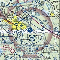
| Sectional chart |
|---|
|
CAUTION: Diagram may not be current
 Download PDF
of official airport diagram from the FAA
| Airport distance calculator |
|---|
|
|
| Sunrise and sunset |
|---|
|
Times for 05-Jun-2026
| | Local
(UTC-5) | | Zulu
(UTC) |
|---|
| Morning civil twilight | | 05:36 | | 10:36 |
| Sunrise | | 06:03 | | 11:03 |
| Sunset | | 19:59 | | 00:59 |
| Evening civil twilight | | 20:26 | | 01:26 |
|
| Current date and time |
|---|
| Zulu (UTC) | 05-Jun-2026 07:12:23 |
|---|
| Local (UTC-5) | 05-Jun-2026 02:12:23 |
|---|
|
| METAR |
|---|
| KHUM | 042347Z 09011KT 7SM FEW035 26/20 A3002
|
|
| TAF |
|---|
| KHUM | 050534Z 0506/0606 09011KT P6SM FEW035 PROB30 0515/0518 4SM -SHRA BKN018 BKN021 FM051800 08010KT 6SM -SHRA SCT019 BKN027 PROB30 0518/0524 4SM -TSRA BKN022CB BKN023 BKN024 FM060000 09009KT P6SM SCT023 BKN027 PROB30 0600/0603 4SM -TSRA BKN023CB FM060500 11006KT P6SM FEW015 SCT035 PROB30 0605/0606 4SM -SHRA BKN015
|
|
| NOTAMs |
|---|
NOTAMs are issued by the DoD/FAA and will open in a separate window not controlled by AirNav.
|
|


