FAA INFORMATION EFFECTIVE 09 JULY 2026
Location
| FAA Identifier: | JRO |
| Lat/Long: | 38-58-52.8970N 082-34-40.2590W
38-58.881617N 082-34.670983W
38.9813603,-82.5778497
(estimated) |
| Elevation: | 726.2 ft. / 221.3 m (surveyed) |
| Variation: | 05W (1985) |
| From city: | 5 miles SE of JACKSON, OH |
| Time zone: | UTC -4 (UTC -5 during Standard Time) |
| Zip code: | 45640 |
Airport Operations
| Airport use: | Open to the public |
| Activation date: | 11/1961 |
| Control tower: | no |
| ARTCC: | INDIANAPOLIS CENTER |
| FSS: | DAYTON FLIGHT SERVICE STATION |
| NOTAMs facility: | JRO (NOTAM-D service available) |
| Attendance: | MON-FRI 0800-1400 |
| Wind indicator: | lighted |
| Segmented circle: | no |
| Lights: | ACTVT MIRL RWY 01/19 - CTAF. PAPI RWY 01 & 19 OPR CONSLY. |
| Beacon: | white-green (lighted land airport)
Operates sunset to sunrise. |
Airport Communications
| CTAF/UNICOM: | 122.7 |
| WX AWOS-3PT: | 118.825 (740-286-1760) |
| HUNTINGTON APPROACH: | 128.4 |
| HUNTINGTON DEPARTURE: | 128.4 |
| WX AWOS-3PT at PMH (15 nm SW): | 125.175 (740-820-2500) |
| WX AWOS-3PT at EOP (20 nm NW): | 121.45 (740-947-0035) |
Nearby radio navigation aids
| VOR radial/distance | | VOR name | | Freq | | Var |
|---|
| XUBr155/(37.6) | | YELLOW BUD VOR | | 112.50 | | 05W |
| NDB name | | Hdg/Dist | | Freq | | Var | | ID |
|---|
| UNIVERSITY | | 238/26.8 | | 250 | | 06W | | UGS | ..- --. ... |
Airport Services
| Fuel available: | 100LL JET-A1+
100LL:100LL & JET A1+ AVBL H24 SELF SVC VIA CREDIT CARD. |
| Parking: | tiedowns |
| Airframe service: | MAJOR |
| Powerplant service: | MAJOR |
| Bottled oxygen: | NONE |
| Bulk oxygen: | NONE |
Runway Information
Runway 1/19
| Dimensions: | 5201 x 75 ft. / 1585 x 23 m |
| Surface: | asphalt, in excellent condition |
| Runway edge lights: | medium intensity |
| RUNWAY 1 | | RUNWAY 19 |
| Latitude: | 38-58.454917N | | 38-59.308332N |
| Longitude: | 082-34.719433W | | 082-34.622533W |
| Elevation: | 722.5 ft. | | 726.2 ft. |
| Traffic pattern: | left | | left |
| Runway heading: | 010 magnetic, 005 true | | 190 magnetic, 185 true |
| Displaced threshold: | 331 ft. | | no |
| Markings: | nonprecision, in good condition | | nonprecision, in good condition |
| Visual slope indicator: | 4-light PAPI on right (4.00 degrees glide path)
PAPI UNUSBL BYD 9 DEGS LEFT OF CNTRLN. | | 4-light PAPI on left (4.00 degrees glide path)
PAPI UNUSBL BYD 7 DEGS RIGHT OF CNTRLN. |
| Runway end identifier lights: | no | | no |
| Touchdown point: | yes, no lights | | yes, no lights |
| Obstructions: | 75 ft. tree, 919 ft. from runway, 175 ft. right of centerline, 9:1 slope to clear
APCH RATIO 15:1 TO DTHR. | | 15 ft. road, 201 ft. from runway, 230 ft. right of centerline
15 FT ROAD, 0-200 FT DIST, 230 FT R. |
Airport Ownership and Management from official FAA records
| Ownership: | Publicly-owned |
| Owner: | JACKSON CO COMM
25 E SOUTH ST, PO BOX 606
JACKSON, OH 45640-0606
Phone 740-286-0137 |
| Manager: | DON LEWIS
1800 KEYSTONE STATION RD
JACKSON, OH 45640-8701
Phone 740-286-0137 |
Additional Remarks
| - | FOR CD CTC HUNTINGTON ATCT AT 304-453-2490. |
Instrument Procedures
NOTE: All procedures below are presented as PDF files. If you need a reader for these files, you should download the free Adobe Reader.NOT FOR NAVIGATION. Please procure official charts for flight.
FAA instrument procedures published for use from 09 July 2026 at 0901Z to 06 August 2026 at 0900Z.
IAPs - Instrument Approach Procedures |
|---|
| RNAV (GPS) RWY 01 | |
download (209KB) |
| RNAV (GPS) RWY 19 | |
download (208KB) |
| NOTE: Special Alternate Minimums apply | |
download (168KB) |
| NOTE: Special Take-Off Minimums/Departure Procedures apply | |
download (482KB) |
Other nearby airports with instrument procedures:
KPMH - Greater Portsmouth Regional Airport (15 nm SW)
KEOP - Pike County Airport (20 nm NW)
KGAS - Gallia-Meigs Regional Airport (21 nm SE)
KUNI - Ohio University Airport (21 nm NE)
KDWU - Ashland Regional Airport (27 nm S)
|
|

Road maps at:
MapQuest
Bing
Google
| Aerial photo |
|---|
WARNING: Photo may not be current or correct
 Taken in October 2006
Do you have a better or more recent aerial photo of James A Rhodes Airport that you would like to share? If so, please send us your photo.
|
| Sectional chart |
|---|
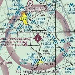
|
| Airport distance calculator |
|---|
|
|
| Sunrise and sunset |
|---|
|
Times for 26-Jul-2026
| | Local
(UTC-4) | | Zulu
(UTC) |
|---|
| Morning civil twilight | | 05:57 | | 09:57 |
| Sunrise | | 06:27 | | 10:27 |
| Sunset | | 20:47 | | 00:47 |
| Evening civil twilight | | 21:17 | | 01:17 |
|
| Current date and time |
|---|
| Zulu (UTC) | 26-Jul-2026 22:12:19 |
|---|
| Local (UTC-4) | 26-Jul-2026 18:12:19 |
|---|
|
| METAR |
|---|
| KJRO | 262155Z AUTO VRB05KT 10SM FEW028 SCT055 28/25 A2991 RMK AO2
|
KPMH
15nm SW | 262148Z AUTO 31006KT 10SM OVC050 27/23 A2991 RMK AO2
|
KEOP
20nm NW | 262155Z AUTO 29006KT 10SM OVC050 27/22 A2990 RMK AO2
|
|
| TAF |
|---|
KHTS
37nm S | 261940Z 2620/2718 VRB05KT P6SM BKN035 PROB30 2622/2701 3SM -TSRA BKN025CB FM270200 00000KT P6SM FEW140 FM270800 00000KT 3SM BR SCT001 BKN014 FM271300 00000KT P6SM SCT040
|
|
| NOTAMs |
|---|
NOTAMs are issued by the DoD/FAA and will open in a separate window not controlled by AirNav.
|
|


