FAA INFORMATION EFFECTIVE 19 MARCH 2026
Location
| FAA Identifier: | UNI |
| Lat/Long: | 39-12-42.8142N 082-13-45.3195W
39-12.713570N 082-13.755325W
39.2118928,-82.2292554
(estimated) |
| Elevation: | 765.7 ft. / 233.4 m (surveyed) |
| Variation: | 06W (1995) |
| From city: | 10 miles SW of central business district of the associated city |
| Time zone: | UTC -4 (UTC -5 during Standard Time) |
| Zip code: | 45710 |
Airport Operations
| Airport use: | Open to the public |
| Control tower: | no |
| ARTCC: | INDIANAPOLIS CENTER |
| FSS: | DAYTON FLIGHT SERVICE STATION |
| NOTAMs facility: | UNI (NOTAM-D service available) |
| Attendance: | CONTINUOUS |
| Pattern altitude: | TPA TURBINE ACFR ( EXCEPT HELICOPTERS) 1534 AGL, MULTI ENGINE RECIP 1234 AGL, ALL OTHERS 1034 AGL. |
| Wind indicator: | lighted |
| Segmented circle: | no |
| Lights: | ACTVT REIL RWY 07 & 25; MIRL RWY 07/25 - CTAF. PAPI RWY 07 & 25 OPR CONSLY. |
| Beacon: | white-green (lighted land airport)
Operates sunset to sunrise. |
Airport Communications
| CTAF/UNICOM: | 123.075 |
| WX AWOS-3: | 128.325 (740-597-2687) |
| HUNTINGTON APPROACH: | 120.95 |
| HUNTINGTON DEPARTURE: | 120.95 |
| CLEARANCE DELIVERY: | 120.95 |
| WX AWOS-3 at 3I2 (19 nm S): | 119.675 (304-675-4618) |
Nearby radio navigation aids
| VOR radial/distance | | VOR name | | Freq | | Var |
|---|
| XUBr124/(39.5) | | YELLOW BUD VOR | | 112.50 | | 05W |
| NDB name | | Hdg/Dist | | Freq | | Var | | ID |
|---|
| UNIVERSITY | | 246/5.5 | | 250 | | 06W | | UGS | ..- --. ... |
Airport Services
| Fuel available: | 100LL JET-A+
A+:ICING INHIBITOR PREBLENDED. |
| Parking: | hangars and tiedowns |
| Airframe service: | MAJOR |
| Powerplant service: | MAJOR |
| Bottled oxygen: | NONE |
| Bulk oxygen: | HIGH |
Runway Information
Runway 7/25
| Dimensions: | 5600 x 100 ft. / 1707 x 30 m |
| Surface: | asphalt, in good condition |
| Weight bearing capacity: | | PCN 20 /F/B/X/U | | Single wheel: | 56.5 | | Double wheel: | 82.0 |
|
| Runway edge lights: | medium intensity |
| RUNWAY 7 | | RUNWAY 25 |
| Latitude: | 39-12.488048N | | 39-12.939092N |
| Longitude: | 082-14.272477W | | 082-13.238172W |
| Elevation: | 765.4 ft. | | 760.5 ft. |
| Traffic pattern: | left | | left |
| Runway heading: | 067 magnetic, 061 true | | 247 magnetic, 241 true |
| Displaced threshold: | 900 ft. | | no |
| Markings: | nonprecision, in fair condition | | precision, in fair condition |
| Visual slope indicator: | 4-light PAPI on left (3.00 degrees glide path) | | 4-light PAPI on left (3.00 degrees glide path) |
| Runway end identifier lights: | yes
LCTD 949 FT FM RWY END. | | yes |
| Touchdown point: | yes, no lights | | yes, no lights |
| Instrument approach: | | | LOC/GS |
| Obstructions: | none | | 51 ft. tree, 1191 ft. from runway, 301 ft. left of centerline, 19:1 slope to clear |
Airport Ownership and Management from official FAA records
| Ownership: | Publicly-owned |
| Owner: | OHIO UNIVERSITY
747 COLUMBIA ROAD
ALBANY, OH 45710
Phone 740-597-2600 |
| Manager: | VICKI SMITH
747 COLUMBIA ROAD
ALBANY, OH 45710
Phone 740-597-2600
FOR EMERG CALL 740-597-2600. |
Additional Remarks
| - | DEER, BIRDS, & OTR WILDLIFE ON & INVOF ARPT. |
| - | RWY 07 & 25 LEFT TFC ONLY; EXTSV FLT TRNG; MAKE EVERY EFFORT TO OBS TPA & AVOID OVERFLIGHT OF NOISE SENSITIVE AREAS, CHURCH 1.8 MI NW OF RWY END 25 & VILLAGE OF ALBANY 2 MI EAST OF AER 25. |
Instrument Procedures
NOTE: All procedures below are presented as PDF files. If you need a reader for these files, you should download the free Adobe Reader.NOT FOR NAVIGATION. Please procure official charts for flight.
FAA instrument procedures published for use from 19 March 2026 at 0901Z to 16 April 2026 at 0900Z.
IAPs - Instrument Approach Procedures |
|---|
| ILS OR LOC RWY 25 | |
download (191KB) |
| RNAV (GPS) RWY 07 **CHANGED** | |
download (217KB) |
| RNAV (GPS) RWY 25 **CHANGED** | |
download (205KB) |
| NDB RWY 25 | |
download (187KB) |
| NOTE: Special Alternate Minimums apply **CHANGED** | |
download (150KB) |
| NOTE: Special Take-Off Minimums/Departure Procedures apply **CHANGED** | |
download (495KB) |
Other nearby airports with instrument procedures:
3I2 - Mason County Airport (19 nm S)
KJRO - James A Rhodes Airport (21 nm SW)
KGAS - Gallia-Meigs Regional Airport (23 nm S)
I18 - Jackson County Airport (26 nm SE)
I86 - Ed Newlon Field Airport (29 nm N)
|
|

Road maps at:
MapQuest
Bing
Google
| Aerial photo |
|---|
WARNING: Photo may not be current or correct
 Photo courtesy of AirNav, LLC
Photo taken 08-May-2011
looking east.
Photo courtesy of AirNav, LLC
Photo taken 08-May-2011
looking east.
Do you have a better or more recent aerial photo of Ohio University Airport that you would like to share? If so, please send us your photo.
|
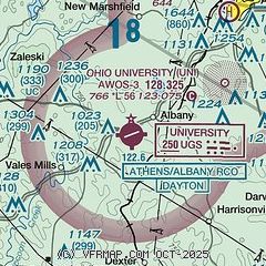
| Sectional chart |
|---|
|
| Airport distance calculator |
|---|
|
|
| Sunrise and sunset |
|---|
|
Times for 11-Apr-2026
| | Local
(UTC-4) | | Zulu
(UTC) |
|---|
| Morning civil twilight | | 06:32 | | 10:32 |
| Sunrise | | 06:59 | | 10:59 |
| Sunset | | 20:01 | | 00:01 |
| Evening civil twilight | | 20:29 | | 00:29 |
|
| Current date and time |
|---|
| Zulu (UTC) | 12-Apr-2026 03:43:08 |
|---|
| Local (UTC-4) | 11-Apr-2026 23:43:08 |
|---|
|
| METAR |
|---|
| KUNI | 120315Z AUTO 00000KT 10SM CLR 09/05 A3032 RMK AO2 T00900052
|
|
| TAF |
|---|
KPKB
39nm E | 111720Z 1118/1218 01005KT P6SM SKC FM121600 20007G15KT P6SM FEW250
|
KZZV
47nm N | 111720Z 1118/1218 VRB04KT P6SM SKC FM121500 20009G15KT P6SM SCT080
|
KLCK
48nm NW | 111720Z 1118/1218 04007KT P6SM FEW250 FM120500 11005KT P6SM BKN200 FM121400 15007KT P6SM SCT250 FM121700 18010G20KT P6SM SCT250
|
|
| NOTAMs |
|---|
NOTAMs are issued by the DoD/FAA and will open in a separate window not controlled by AirNav.
|
|


