FAA INFORMATION EFFECTIVE 11 JUNE 2026
Location
| FAA Identifier: | JWY |
| Lat/Long: | 32-27-29.8550N 096-54-45.0950W
32-27.497583N 096-54.751583W
32.4582931,-96.9125264
(estimated) |
| Elevation: | 727 ft. / 222 m (estimated) |
| Variation: | 06E (1995) |
| From city: | 5 miles SE of central business district of the associated city |
| Time zone: | UTC -5 (UTC -6 during Standard Time) |
| Zip code: | 76065 |
Airport Operations
| Airport use: | Open to the public |
| Activation date: | 07/1992 |
| Control tower: | no |
| ARTCC: | FORT WORTH CENTER |
| FSS: | FORT WORTH FLIGHT SERVICE STATION |
| NOTAMs facility: | JWY (NOTAM-D service available) |
| Attendance: | MAR-OCT MON-SAT 0800-1900, NOV-FEB MON-SAT 0800-1800, MAR-OCT SUN 0900-1900, NOV-FEB SUN 0900-1800 |
| Wind indicator: | lighted |
| Segmented circle: | yes |
| Lights: | ACTVT REIL RWY 18; MIRL RWY 18/36 - CTAF. |
| Beacon: | white-green (lighted land airport)
Operates sunset to sunrise. |
Airport Communications
| CTAF/UNICOM: | 122.975 |
| WX AWOS-3P: | 119.575 (972-227-0471) |
| LONE STAR APPROACH: | 125.2 [MIDLAND 0600-0000 SAN ANGELO 0600-2100] |
| LONE STAR DEPARTURE: | 125.2 [MIDLAND 0600-0000 SAN ANGELO 0600-2100] |
| BOTCH DP: | 125.2 |
| DODJE STAR: | 125.2 125.9 |
| FINGR STAR: | 124.3 125.275 |
| GARLAND DP: | 125.2 |
| GREGS STAR: | 118.1 |
| HERBZ STAR: | 118.1 |
| JFRYE STAR: | 118.1 |
| JOE POOL DP: | 125.2 |
| NANDR RNAV DP: | 125.2 |
| REEKO STAR: | 125.2 |
| SLANT STAR: | 125.275 |
| SWVAY STAR: | 135.975 |
| WX AWOS-3PT at LNC (12 nm NE): | 118.975 (972-227-0471) |
| WX ASOS at RBD (14 nm N): | PHONE 214-330-5317 |
| WX ASOS at GKY (15 nm NW): | 127.375 (817-557-0251) |
| WX AWOS-3P at GPM (16 nm NW): | 118.475 (972-606-1433) |
| WX AWOS-3 at 49T (20 nm N): | 135.425 (214-670-1243) |
Nearby radio navigation aids
| VOR radial/distance | | VOR name | | Freq | | Var |
|---|
| TTTr159/25.5 | | MAVERICK VOR/DME | | 113.10 | | 06E |
| CVEr175/25.9 | | COWBOY VOR/DME | | 116.20 | | 06E |
| FUZr146/29.2 | | RANGER VORTAC | | 115.70 | | 06E |
| CQYr289/38.8 | | CEDAR CREEK VORTAC | | 114.80 | | 06E |
Airport Services
| Fuel available: | 100LL JET-A
100LL:FOR FUEL & SVCS AFT HRS CALL 214-762-8286 OR 972-979-5723. |
| Parking: | tiedowns |
| Airframe service: | MAJOR |
| Powerplant service: | MAJOR |
Runway Information
Runway 18/36
| Dimensions: | 6500 x 100 ft. / 1981 x 30 m |
| Surface: | asphalt, in good condition |
| Weight bearing capacity: | | Single wheel: | 30.0 | | Double wheel: | 90.0 |
|
| Runway edge lights: | medium intensity |
| RUNWAY 18 | | RUNWAY 36 |
| Latitude: | 32-28.032333N | | 32-26.962905N |
| Longitude: | 096-54.707608W | | 096-54.795432W |
| Elevation: | 727.0 ft. | | 686.3 ft. |
| Traffic pattern: | left | | left |
| Runway heading: | 178 magnetic, 184 true | | 358 magnetic, 004 true |
| Markings: | precision, in fair condition | | nonprecision, in good condition |
| Visual slope indicator: | 4-light PAPI on right (3.00 degrees glide path) | | 4-light PAPI on left (3.00 degrees glide path) |
| Runway end identifier lights: | yes | | no |
| Touchdown point: | yes, no lights | | yes, no lights |
| Obstructions: | 26 ft. trees, 1254 ft. from runway, 630 ft. left and right of centerline, 40:1 slope to clear
CONTROLLING OBSTRUCTION EXCEEDS A 45 DEGREE SLOPE | | 27 ft. pline, 224 ft. from runway, 503 ft. left of centerline |
Airport Ownership and Management from official FAA records
| Ownership: | Publicly-owned |
| Owner: | MIDLOTHIAN & WAXAHACHIE CITY
408 S. ROGERS
WAXAHACHIE, TX 75165
Phone 469-309-4000
WAXAHACHIE CITY HALL. |
| Manager: | SHARLETTE WRIGHT
131 AIRPORT DRIVE, STE 101
MIDLOTHIAN, TX 76065
Phone 972-923-0080 |
Additional Remarks
| - | GLIDER OPNS ON ARPT. |
| - | FOR CD CTC LONE STAR APCH AT 972-615-2799. |
Instrument Procedures
NOTE: All procedures below are presented as PDF files. If you need a reader for these files, you should download the free Adobe Reader.NOT FOR NAVIGATION. Please procure official charts for flight.
FAA instrument procedures published for use from 11 June 2026 at 0901Z to 09 July 2026 at 0900z.
STARs - Standard Terminal Arrivals |
|---|
| DODJE SIX **NEW** | |
2 pages:
[1] [2] (672KB) |
| FINGR ONE **NEW** | |
2 pages:
[1] [2] (428KB) |
| GREGS ONE **NEW** | |
2 pages:
[1] [2] (468KB) |
| HERBZ TWO (RNAV) **NEW** | |
download (281KB) |
| JFRYE FIVE (RNAV) **NEW** | |
download (257KB) |
| REEKO THREE (RNAV) **NEW** | |
download (214KB) |
| SLANT THREE (RNAV) **NEW** | |
download (253KB) |
| SWVAY FOUR (RNAV) **NEW** | |
download (238KB) |
| WESAT THREE (RNAV) **NEW** | |
download (209KB) |
IAPs - Instrument Approach Procedures |
|---|
| RNAV (GPS) RWY 18 | |
download (175KB) |
| RNAV (GPS) RWY 36 | |
download (249KB) |
| NOTE: Special Alternate Minimums apply | |
download (117KB) |
Departure Procedures |
|---|
| BOTCH TWO (RNAV) **NEW** | |
2 pages:
[1] [2] (341KB) |
| GARLAND SIX | |
2 pages:
[1] [2] (328KB) |
| JOE POOL EIGHT | |
2 pages:
[1] [2] (448KB) |
| KINGDOM FIVE | |
2 pages:
[1] [2] (351KB) |
| KUSSO THREE (RNAV) **NEW** | |
2 pages:
[1] [2] (327KB) |
| NANDR FOUR (RNAV) **NEW** | |
2 pages:
[1] [2] (310KB) |
| NOTE: Special Take-Off Minimums/Departure Procedures apply | |
download |
Other nearby airports with instrument procedures:
KLNC - Lancaster Regional Airport (12 nm NE)
KRBD - Dallas Executive Airport (14 nm N)
F41 - Ennis Municipal Airport (15 nm SE)
KGKY - Arlington Municipal Airport (15 nm NW)
KGPM - Grand Prairie Municipal Airport (16 nm NW)
|
|

Road maps at:
MapQuest
Bing
Google
| Aerial photo |
|---|
WARNING: Photo may not be current or correct
 Photo by Jean-Claude DeMars
Taken in June 2011
looking south.
Photo by Jean-Claude DeMars
Taken in June 2011
looking south.
Do you have a better or more recent aerial photo of Mid-Way Regional Airport that you would like to share? If so, please send us your photo.
|
| Sectional chart |
|---|
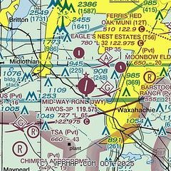
|
CAUTION: Diagram may not be current

| Airport distance calculator |
|---|
|
|
| Sunrise and sunset |
|---|
|
Times for 24-Jun-2026
| | Local
(UTC-5) | | Zulu
(UTC) |
|---|
| Morning civil twilight | | 05:54 | | 10:54 |
| Sunrise | | 06:23 | | 11:23 |
| Sunset | | 20:37 | | 01:37 |
| Evening civil twilight | | 21:06 | | 02:06 |
|
| Current date and time |
|---|
| Zulu (UTC) | 25-Jun-2026 00:00:46 |
|---|
| Local (UTC-5) | 24-Jun-2026 19:00:46 |
|---|
|
| METAR |
|---|
| KJWY | 242335Z AUTO 18010KT 10SM FEW055 33/22 A2995 RMK AO2 T03310224 $
|
KRBD
14nm N | 242353Z 20009KT 10SM CLR 33/21 A2993 RMK AO2 SLP125 T03280211 10339 20317 56016
|
KGKY
16nm NW | 242353Z 15011KT 10SM FEW055 33/21 A2993 RMK AO2 SLP123 T03330206 10344 20317 56018
|
KGPM
16nm NW | 242335Z AUTO 17009KT 10SM SCT050 34/20 A2994 RMK AO2 T03350196
|
|
| TAF |
|---|
KGKY
16nm NW | 242051Z 2421/2518 18012KT P6SM SCT050 FM251600 19014G24KT P6SM SCT120
|
|
| NOTAMs |
|---|
NOTAMs are issued by the DoD/FAA and will open in a separate window not controlled by AirNav.
|
|


