FAA INFORMATION EFFECTIVE 16 APRIL 2026
Location
| FAA Identifier: | LUG |
| Lat/Long: | 35-30-25.1070N 086-48-13.9950W
35-30.418450N 086-48.233250W
35.5069742,-86.8038875
(estimated) |
| Elevation: | 718.4 ft. / 219.0 m (surveyed) |
| Variation: | 03W (2010) |
| From city: | 3 miles N of LEWISBURG, TN |
| Time zone: | UTC -5 (UTC -6 during Standard Time) |
| Zip code: | 37091 |
Airport Operations
| Airport use: | Open to the public |
| Activation date: | 07/1961 |
| Control tower: | no |
| ARTCC: | MEMPHIS CENTER |
| FSS: | JACKSON FLIGHT SERVICE STATION |
| NOTAMs facility: | MKL (NOTAM-D service available) |
| Attendance: | MON-FRI 0800-1700, ALL SAT 0800-1500 |
| Wind indicator: | lighted |
| Segmented circle: | yes |
| Lights: | SS-SR |
| Beacon: | white-green (lighted land airport)
Operates sunset to sunrise. |
Airport Communications
| CTAF/UNICOM: | 122.8 |
| WX AWOS-3: | 135.775 (931-270-1014) |
| WX AWOS-3 at SYI (18 nm E): | 119.275 (931-685-4723) |
| WX AWOS-3 at MRC (19 nm W): | 128.625 (931-379-0844) |
- APCH/DEP SVC PRVDD BY MEMPHIS ARTCC ON FREQS 128.15/323.125 (SHELBYVILLE RCAG).
Nearby radio navigation aids
| VOR radial/distance | | VOR name | | Freq | | Var |
|---|
| SYIr261/18.1 | | SHELBYVILLE VOR/DME | | 113.55 | | 01W |
| BNAr191/38.2 | | NASHVILLE VORTAC | | 114.10 | | 02W |
Airport Services
| Fuel available: | 100LL JET-A+ |
| Parking: | hangars and tiedowns |
| Airframe service: | MAJOR |
| Powerplant service: | MAJOR |
Runway Information
Runway 2/20
| Dimensions: | 5001 x 100 ft. / 1524 x 30 m |
| Surface: | asphalt, in good condition |
| Weight bearing capacity: | | PCN 33 /F/C/X/T | | Single wheel: | 85.0 | | Double wheel: | 115.0 |
|
| Runway edge lights: | medium intensity |
| RUNWAY 2 | | RUNWAY 20 |
| Latitude: | 35-30.026747N | | 35-30.810140N |
| Longitude: | 086-48.390200W | | 086-48.076288W |
| Elevation: | 718.4 ft. | | 709.6 ft. |
| Traffic pattern: | left | | left |
| Runway heading: | 021 magnetic, 018 true | | 201 magnetic, 198 true |
| Markings: | nonprecision, in fair condition | | nonprecision, in fair condition |
| Visual slope indicator: | 2-light PAPI on left (3.30 degrees glide path) | | 2-light PAPI on left (3.00 degrees glide path) |
| Runway end identifier lights: | yes | | yes |
| Touchdown point: | yes, no lights | | yes, no lights |
| Obstructions: | 51 ft. tree, 1345 ft. from runway, 173 ft. right of centerline, 22:1 slope to clear | | 48 ft. tree, 1202 ft. from runway, 291 ft. right of centerline, 20:1 slope to clear |
Airport Ownership and Management from official FAA records
| Ownership: | Publicly-owned |
| Owner: | CITY OF LEWISBURG
131 EAST CHURCH STREET
LEWISBURG, TN 37091
Phone 931-359-1544 |
| Manager: | KENT STEWMON
1877 FRANKLIN PIKE
LEWISBURG, TN 37091
Phone 931-359-5003 |
Additional Remarks
| - | FOR CD CTC MEMPHIS ARTCC AT 901-368-8453/8449. |
Instrument Procedures
NOTE: All procedures below are presented as PDF files. If you need a reader for these files, you should download the free Adobe Reader.NOT FOR NAVIGATION. Please procure official charts for flight.
FAA instrument procedures published for use from 16 April 2026 at 0901Z to 14 May 2026 at 0900Z.
IAPs - Instrument Approach Procedures |
|---|
| RNAV (GPS) RWY 02 | |
download (267KB) |
| RNAV (GPS) RWY 20 | |
download (214KB) |
| NOTE: Special Take-Off Minimums/Departure Procedures apply | |
download (165KB) |
Other nearby airports with instrument procedures:
KSYI - Bomar Field/Shelbyville Municipal Airport (18 nm E)
KMRC - Maury County Regional Airport (19 nm W)
KGZS - Abernathy Field Airport (25 nm SW)
2M2 - Lawrenceburg/Lawrence County Airport (Fleeman Field) (28 nm SW)
KTHA - Tullahoma Regional Airport/William Northern Field (28 nm E)
|
|

Road maps at:
MapQuest
Bing
Google
| Aerial photo |
|---|
WARNING: Photo may not be current or correct
 Photo by Eve Cascella
Photo taken 20-Aug-2008
from the south looking north
Photo by Eve Cascella
Photo taken 20-Aug-2008
from the south looking north
Do you have a better or more recent aerial photo of Ellington Airport that you would like to share? If so, please send us your photo.
|
| Sectional chart |
|---|
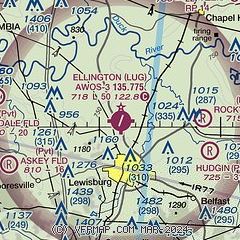
|
| Airport distance calculator |
|---|
|
|
| Sunrise and sunset |
|---|
|
Times for 12-May-2026
| | Local
(UTC-5) | | Zulu
(UTC) |
|---|
| Morning civil twilight | | 05:18 | | 10:18 |
| Sunrise | | 05:46 | | 10:46 |
| Sunset | | 19:41 | | 00:41 |
| Evening civil twilight | | 20:09 | | 01:09 |
|
| Current date and time |
|---|
| Zulu (UTC) | 12-May-2026 20:55:55 |
|---|
| Local (UTC-5) | 12-May-2026 15:55:55 |
|---|
|
| METAR |
|---|
| KLUG | 122035Z AUTO VRB05G10KT 10SM FEW060 25/10 A3008 RMK A01
|
KSYI
18nm E | 122035Z AUTO 17007KT 10SM CLR 25/11 A3007 RMK A01
|
KMRC
19nm W | 122035Z AUTO 21005KT 10SM CLR 26/07 A3006 RMK A01
|
|
| NOTAMs |
|---|
NOTAMs are issued by the DoD/FAA and will open in a separate window not controlled by AirNav.
|
|

