FAA INFORMATION EFFECTIVE 11 JUNE 2026
Location
| FAA Identifier: | LUM |
| Lat/Long: | 44-53-32.4390N 091-52-04.0460W
44-53.540650N 091-52.067433W
44.8923442,-91.8677906
(estimated) |
| Elevation: | 895 ft. / 272.8 m (surveyed) |
| Variation: | 01E (2000) |
| From city: | 3 miles E of MENOMONIE, WI |
| Time zone: | UTC -5 (UTC -6 during Standard Time) |
| Zip code: | 54751 |
Airport Operations
| Airport use: | Open to the public |
| Activation date: | 06/1986 |
| Control tower: | no |
| ARTCC: | MINNEAPOLIS CENTER |
| FSS: | GREEN BAY FLIGHT SERVICE STATION |
| NOTAMs facility: | LUM (NOTAM-D service available) |
| Attendance: | MON-FRI 0800-1700 |
| Wind indicator: | lighted |
| Segmented circle: | no |
| Lights: | MIRL RWY 9/27 PRESET TO LOW SS-SR; TO INCR INTST AND ACTVT REIL RWYS 09 & 27; PAPI RWYS 09, 18, 27, & 36; MIRL RWY 09/27 & 18/36 - CTAF. |
| Beacon: | white-green (lighted land airport)
Operates sunset to sunrise. |
Airport Communications
| CTAF/UNICOM: | 123.075 |
| WX AWOS-3PT: | 118.025 |
| WX ASOS at EAU (16 nm E): | 126.025 (715-832-7990) |
- APCH/DEP SVC PRVDD BY MINNEAPOLIS ARTCC ON FREQS 125.3/335.6 (EAU CLAIRE RCAG).
Nearby radio navigation aids
| VOR radial/distance | | VOR name | | Freq | | Var |
|---|
| EAUr265/16.5 | | EAU CLAIRE VORTAC | | 113.65 | | 04E |
Airport Services
| Fuel available: | 100LL JET-A+
100LL:24 HR SELF SVC FUEL AVBL WITH CREDIT CARD; CTC AMGR FOR ASSTNC. |
| Parking: | hangars and tiedowns |
| Airframe service: | MAJOR |
| Powerplant service: | MAJOR |
| Bottled oxygen: | NONE |
Runway Information
Runway 9/27
| Dimensions: | 5074 x 75 ft. / 1547 x 23 m |
| Surface: | asphalt, in fair condition |
| Runway edge lights: | medium intensity |
| RUNWAY 9 | | RUNWAY 27 |
| Latitude: | 44-53.449222N | | 44-53.458713N |
| Longitude: | 091-52.614590W | | 091-51.440150W |
| Elevation: | 892.3 ft. | | 892.6 ft. |
| Traffic pattern: | left | | left |
| Runway heading: | 088 magnetic, 089 true | | 268 magnetic, 269 true |
| Markings: | nonprecision, in fair condition | | nonprecision, in fair condition |
| Visual slope indicator: | 2-light PAPI on left (3.00 degrees glide path) | | 2-light PAPI on left (3.00 degrees glide path) |
| Runway end identifier lights: | yes | | yes |
| Touchdown point: | yes, no lights | | yes, no lights |
| Obstructions: | none
CTLNG OBSTN EXCEEDS A 45 DEG SLP. | | 15 ft. other, 200 ft. from runway, 300 ft. left of centerline
20 FT BLDG 100 FT FM RWY END, 325 FT L. |
Runway 18/36
| Dimensions: | 3470 x 75 ft. / 1058 x 23 m |
| Surface: | asphalt, in fair condition |
| Runway edge lights: | medium intensity |
| RUNWAY 18 | | RUNWAY 36 |
| Latitude: | 44-53.952550N | | 44-53.382152N |
| Longitude: | 091-52.145558W | | 091-52.106442W |
| Elevation: | 895.0 ft. | | 892.9 ft. |
| Traffic pattern: | left | | left |
| Runway heading: | 176 magnetic, 177 true | | 356 magnetic, 357 true |
| Markings: | nonprecision, in fair condition | | nonprecision, in fair condition |
| Visual slope indicator: | 2-light PAPI on left (3.00 degrees glide path) | | 2-light PAPI on right (3.00 degrees glide path) |
| Runway end identifier lights: | no | | |
| Touchdown point: | yes, no lights | | yes, no lights |
Airport Ownership and Management from official FAA records
| Ownership: | Publicly-owned |
| Owner: | CITY OF MENOMONIE
800 WILSON AVE
MENOMONIE, WI 54751-2795
Phone 715-232-2187 |
| Manager: | DARREL GIBSON
1400 INDIANHEAD DR.
MENOMONIE, WI 54751
Phone 715-220-6549 |
Additional Remarks
| - | SEASONAL BIRDS ON & INVOF ARPT. |
| - | FOR CD CTC MINNEAPOLIS ARTCC AT 651-463-5588. |
| - | NOISE SENSITIVE NBRHD W OF RWY 27. |
Instrument Procedures
NOTE: All procedures below are presented as PDF files. If you need a reader for these files, you should download the free Adobe Reader.NOT FOR NAVIGATION. Please procure official charts for flight.
FAA instrument procedures published for use from 11 June 2026 at 0901Z to 09 July 2026 at 0900z.
IAPs - Instrument Approach Procedures |
|---|
| RNAV (GPS) RWY 09 | |
download (228KB) |
| RNAV (GPS) RWY 27 | |
download (212KB) |
| VOR/DME RWY 27 | |
download (222KB) |
| NOTE: Special Alternate Minimums apply | |
download (139KB) |
| NOTE: Special Take-Off Minimums/Departure Procedures apply | |
download (483KB) |
Other nearby airports with instrument procedures:
3T3 - Boyceville Municipal Airport (11 nm NW)
KEAU - Chippewa Valley Regional Airport (16 nm E)
Y23 - Chetek Municipal/Southworth Airport (27 nm N)
KAHH - Amery Municipal Airport (32 nm NW)
KRPD - Rice Lake Regional Airport - Carl's Field (32 nm N)
|
|

Road maps at:
MapQuest
Bing
Google
| Aerial photo |
|---|
WARNING: Photo may not be current or correct
 Photo taken 09-Oct-2016
looking west.
Photo taken 09-Oct-2016
looking west.
Do you have a better or more recent aerial photo of Menomonie Municipal Airport-Score Field that you would like to share? If so, please send us your photo.
|
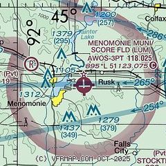
| Sectional chart |
|---|
|
| Airport distance calculator |
|---|
|
|
| Sunrise and sunset |
|---|
|
Times for 06-Jul-2026
| | Local
(UTC-5) | | Zulu
(UTC) |
|---|
| Morning civil twilight | | 04:52 | | 09:52 |
| Sunrise | | 05:29 | | 10:29 |
| Sunset | | 20:55 | | 01:55 |
| Evening civil twilight | | 21:32 | | 02:32 |
|
| Current date and time |
|---|
| Zulu (UTC) | 06-Jul-2026 15:13:20 |
|---|
| Local (UTC-5) | 06-Jul-2026 10:13:20 |
|---|
|
| METAR |
|---|
| KLUM | 061455Z AUTO 16004KT 10SM CLR 26/21 A3011 RMK AO2 T02590205 PWINO
|
KEAU
17nm E | 061456Z 00000KT 10SM CLR 25/18 A3010 RMK AO2 SLP188 T02500183 56006
|
|
| TAF |
|---|
KEAU
17nm E | 061120Z 0612/0712 VRB02KT 6SM BR SKC FM061300 14003KT P6SM SKC FM061500 17004KT P6SM FEW050 FEW250 FM070100 18004KT P6SM SCT250 FM070500 18004KT P6SM BKN250
|
|
| NOTAMs |
|---|
NOTAMs are issued by the DoD/FAA and will open in a separate window not controlled by AirNav.
|
|

