FAA INFORMATION EFFECTIVE 09 JULY 2026
Location
| FAA Identifier: | MFI |
| Lat/Long: | 44-38-12.8120N 090-11-21.5430W
44-38.213533N 090-11.359050W
44.6368922,-90.1893175
(estimated) |
| Elevation: | 1277.8 ft. / 389.5 m (surveyed) |
| Variation: | 00E (1995) |
| From city: | 1 mile S of MARSHFIELD, WI |
| Time zone: | UTC -5 (UTC -6 during Standard Time) |
| Zip code: | 54449 |
Airport Operations
| Airport use: | Open to the public |
| Activation date: | 09/1945 |
| Control tower: | no |
| ARTCC: | MINNEAPOLIS CENTER |
| FSS: | GREEN BAY FLIGHT SERVICE STATION |
| NOTAMs facility: | MFI (NOTAM-D service available) |
| Attendance: | MON-SAT 0800-1700
FOR AFT HRS SVC CALL 715-743-6634. |
| Wind indicator: | lighted |
| Segmented circle: | no |
| Lights: | MIRL RWY 05/23 & RWY 16/34 PRESET TO LOW SS-SR; TO INCR INTST AND ACTVT MALSR RWY 34; REIL RWY 16; VASI RWY 16 & 34; PAPI RWY 05; MIRL RWY 5/23 & RWY 16/34 - CTAF. |
| Beacon: | white-green (lighted land airport)
Operates sunset to sunrise. |
Airport Communications
| CTAF/UNICOM: | 123.0 |
| WX ASOS: | 121.575 (715-384-3046) |
- APCH/DEP SVC PRVDD BY MINNEAPOLIS ARTCC ON FREQS 124.4/317.7 (MOSINEE RCAG).
Airport Services
| Fuel available: | 100LL JET-A+
100LL:24 HR FUEL AVBL WITH CREDIT CARD. |
| Parking: | hangars and tiedowns |
| Airframe service: | MAJOR |
| Powerplant service: | MINOR |
| Bottled oxygen: | NONE |
| Bulk oxygen: | NONE |
Runway Information
Runway 16/34
| Dimensions: | 5003 x 100 ft. / 1525 x 30 m |
| Surface: | asphalt, in fair condition |
| Weight bearing capacity: | | Single wheel: | 35.0 | | Double wheel: | 50.0 |
|
| Runway edge lights: | medium intensity |
| RUNWAY 16 | | RUNWAY 34 |
| Latitude: | 44-38.660037N | | 44-37.893835N |
| Longitude: | 090-11.648317W | | 090-11.226640W |
| Elevation: | 1277.8 ft. | | 1255.2 ft. |
| Traffic pattern: | right | | left |
| Runway heading: | 159 | | 339 |
| Markings: | nonprecision, in good condition | | nonprecision, in good condition |
| Visual slope indicator: | 2-box VASI on left (3.00 degrees glide path) | | 2-box VASI on left (3.00 degrees glide path) |
| Approach lights: | | | MALSR: 1,400 foot medium intensity approach lighting system with runway alignment indicator lights |
| Runway end identifier lights: | yes | | no |
| Touchdown point: | yes, no lights | | yes, no lights |
| Instrument approach: | | | SDF |
| Obstructions: | 120 ft. trees, 2280 ft. from runway, 580 ft. right of centerline, 17:1 slope to clear | | 15 ft. trees, 230 ft. from runway, 480 ft. left of centerline, 2:1 slope to clear |
Runway 5/23
| Dimensions: | 3600 x 100 ft. / 1097 x 30 m |
| Surface: | asphalt, in fair condition |
| Weight bearing capacity: | | Single wheel: | 35.0 | | Double wheel: | 45.0 |
|
| Runway edge lights: | medium intensity |
| RUNWAY 5 | | RUNWAY 23 |
| Latitude: | 44-37.921480N | | 44-38.329340N |
| Longitude: | 090-11.551060W | | 090-10.949162W |
| Elevation: | 1252.6 ft. | | 1249.2 ft. |
| Traffic pattern: | right | | left |
| Runway heading: | 046 | | 227 |
| Markings: | nonprecision, in good condition | | nonprecision, in good condition |
| Visual slope indicator: | 2-light PAPI on left (3.00 degrees glide path) | | |
| Runway end identifier lights: | no | | |
| Touchdown point: | yes, no lights | | yes, no lights |
| Obstructions: | 35 ft. trees, 500 ft. from runway, 200 ft. left of centerline, 8:1 slope to clear | | none |
Airport Ownership and Management from official FAA records
| Ownership: | Publicly-owned |
| Owner: | CITY OF MARSHFIELD
P.O. BOX 727
MARSHFIELD, WI 54449-0727
Phone 715-384-2919 |
| Manager: | JEFF GAIER
400 W 29TH ST
MARSHFIELD, WI 54449
Phone 715-387-2211 |
Additional Remarks
| - | BIRDS, WATERFOWL & DEER ON & INVOF ARPT. |
| - | RY 34 DEPARTING ACFT CLIMB TO 2000 FT MSL PRIOR TO INITIATING RIGHT TURN. |
| - | FOR CD IF UNA TO CTC ON FSS FREQ, CTC MINNEAPOLIS ARTCC AT 651-463-5588. |
Instrument Procedures
NOTE: All procedures below are presented as PDF files. If you need a reader for these files, you should download the free Adobe Reader.NOT FOR NAVIGATION. Please procure official charts for flight.
FAA instrument procedures published for use from 09 July 2026 at 0901Z to 06 August 2026 at 0900Z.
IAPs - Instrument Approach Procedures |
|---|
| RNAV (GPS) RWY 05 | |
download (211KB) |
| RNAV (GPS) RWY 16 | |
download (251KB) |
| RNAV (GPS) RWY 23 | |
download (208KB) |
| RNAV (GPS) RWY 34 | |
download (222KB) |
| NOTE: Special Alternate Minimums apply | |
download (112KB) |
| NOTE: Special Take-Off Minimums/Departure Procedures apply | |
download (504KB) |
Other nearby airports with instrument procedures:
KVIQ - Neillsville Municipal Airport (15 nm W)
KISW - Alexander Field South Wood County Airport (22 nm SE)
KCWA - Central Wisconsin Airport (24 nm E)
KMDZ - Taylor County Airport (28 nm N)
KSTE - Stevens Point Municipal Airport (29 nm E)
|
|

Road maps at:
MapQuest
Bing
Google
| Aerial photo |
|---|
WARNING: Photo may not be current or correct
 Photo by Mark Robinson
www.wemakepilots.com
Photo taken 14-Jul-2020
looking northeast.
Do you have a better or more recent aerial photo of Marshfield Municipal Airport that you would like to share? If so, please send us your photo.
|
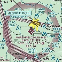
| Sectional chart |
|---|
|
| Airport distance calculator |
|---|
|
|
| Sunrise and sunset |
|---|
|
Times for 22-Jul-2026
| | Local
(UTC-5) | | Zulu
(UTC) |
|---|
| Morning civil twilight | | 05:03 | | 10:03 |
| Sunrise | | 05:37 | | 10:37 |
| Sunset | | 20:37 | | 01:37 |
| Evening civil twilight | | 21:12 | | 02:12 |
|
| Current date and time |
|---|
| Zulu (UTC) | 22-Jul-2026 21:10:39 |
|---|
| Local (UTC-5) | 22-Jul-2026 16:10:39 |
|---|
|
| METAR |
|---|
| KMFI | 222054Z AUTO 31007KT 10SM OVC075 21/07 A3011 RMK AO2 SLP198 T02110072 58007
|
|
| TAF |
|---|
KCWA
24nm E | 221731Z 2218/2318 31007G14KT P6SM BKN060 FM230200 VRB03KT P6SM SKC FM231500 24007KT P6SM FEW060
|
|
| NOTAMs |
|---|
NOTAMs are issued by the DoD/FAA and will open in a separate window not controlled by AirNav.
|
|

