FAA INFORMATION EFFECTIVE 25 DECEMBER 2025
Location
| FAA Identifier: | MMI |
| Lat/Long: | 35-23-57.1000N 084-33-42.4000W
35-23.951667N 084-33.706667W
35.3991944,-84.5617778
(estimated) |
| Elevation: | 874.3 ft. / 266 m (estimated) |
| Variation: | 03W (1990) |
| From city: | 3 miles SE of ATHENS, TN |
| Time zone: | UTC -5 (UTC -4 during Daylight Saving Time) |
| Zip code: | 37303 |
Airport Operations
| Airport use: | Open to the public |
| Activation date: | 09/1951 |
| Control tower: | no |
| ARTCC: | ATLANTA CENTER |
| FSS: | NASHVILLE FLIGHT SERVICE STATION |
| NOTAMs facility: | BNA (NOTAM-D service available) |
| Attendance: | SUN 1230-1700, ALL MON-SAT 0830-1700
CLD EASTER, THANKSGIVING & CHRISTMAS. |
| Wind indicator: | lighted |
| Segmented circle: | yes |
| Lights: | SS-SR |
| Beacon: | white-green (lighted land airport)
Operates sunset to sunrise. |
Airport Communications
| CTAF/UNICOM: | 122.8 |
| WX AWOS-3: | 125.425 (423-745-3422) |
| KNOXVILLE APPROACH: | 123.9 [0500-0000] |
| KNOXVILLE DEPARTURE: | 123.9 [0500-0000] |
| WX AWOS-3 at MNV (12 nm NE): | 118.475 (423-442-6170) |
| WX AWOS-3 at RZR (16 nm SW): | 120.475 (423-479-6823) |
| WX AWOS-3 at 2A0 (19 nm W): | 135.075 (423-775-4695) |
Nearby radio navigation aids
| VOR radial/distance | | VOR name | | Freq | | Var |
|---|
| HCHr140/30.6 | | HINCH MOUNTAIN VOR/DME | | 117.60 | | 02W |
| NDB name | | Hdg/Dist | | Freq | | Var | | ID |
|---|
| DAISY | | 066/32.3 | | 341 | | 02W | | CQN | -.-. --.- -. |
Airport Services
| Fuel available: | 100LL JET-A+ |
| Parking: | hangars and tiedowns |
Runway Information
Runway 2/20
| Dimensions: | 6450 x 100 ft. / 1966 x 30 m |
| Surface: | asphalt, in good condition |
| Weight bearing capacity: | | PCN 15 /F/D/X/T | | Single wheel: | 39.5 | | Double wheel: | 52.0 |
|
| Runway edge lights: | medium intensity |
| Runway edge markings: | FADED. |
| RUNWAY 2 | | RUNWAY 20 |
| Latitude: | 35-23.448000N | | 35-24.455000N |
| Longitude: | 084-33.915500W | | 084-33.499000W |
| Elevation: | 806.5 ft. | | 874.3 ft. |
| Traffic pattern: | left | | left |
| Runway heading: | 022 magnetic, 019 true | | 202 magnetic, 199 true |
| Displaced threshold: | 949 ft. | | no |
| Markings: | nonprecision, in poor condition | | nonprecision, in poor condition |
| Visual slope indicator: | 2-light PAPI on left (3.00 degrees glide path)
PAPI UNUSBL BYD 7 DEGS LEFT OF CNTRLN. | | 2-light PAPI on left (3.00 degrees glide path) |
| Runway end identifier lights: | yes | | yes |
| Touchdown point: | yes, no lights | | yes, no lights |
| Obstructions: | 74 ft. trees, 1189 ft. from runway, 137 ft. left of centerline, 13:1 slope to clear
APCH SLOPE 36:1 TO DTHR. | | 68 ft. trees, 1522 ft. from runway, 157 ft. left of centerline, 19:1 slope to clear |
Airport Ownership and Management from official FAA records
| Ownership: | Publicly-owned |
| Owner: | MCMINN COUNTY
COUNTY COURTHOUSE, 6 EAST MADISON AVENUE
ATHENS, TN 37303
Phone 423-745-7634 |
| Manager: | KRISTY GENTRY COX
195 COUNTY ROAD 552
ATHENS, TN 37303
Phone 423-745-4939 |
Additional Remarks
| - | WILDLIFE ON & INVOF ARPT. |
| - | FOR CD CTC KNOXVILLE APCH AT 865-980-3034; IF UNA FOR CD CTC KNOXVILLE APCH AT 865-980-3033. |
Instrument Procedures
NOTE: All procedures below are presented as PDF files. If you need a reader for these files, you should download the free Adobe Reader.NOT FOR NAVIGATION. Please procure official charts for flight.
FAA instrument procedures published for use from 25 December 2025 at 0901z to 22 January 2026 at 0900z.
IAPs - Instrument Approach Procedures |
|---|
| RNAV (GPS) RWY 02 | |
download (230KB) |
| RNAV (GPS) RWY 20 | |
download (269KB) |
| NOTE: Special Alternate Minimums apply | |
download (162KB) |
| NOTE: Special Take-Off Minimums/Departure Procedures apply | |
download (363KB) |
Other nearby airports with instrument procedures:
KMNV - Monroe County Airport (12 nm NE)
KRZR - Cleveland Regional Jetport (16 nm SW)
2A0 - Mark Anton Airport (19 nm W)
1A3 - Martin Campbell Field Airport (25 nm SE)
KRKW - Rockwood Municipal Airport (32 nm N)
|
|

Road maps at:
MapQuest
Bing
Google
| Aerial photo |
|---|
WARNING: Photo may not be current or correct
 Photo taken 13-Jun-2008
Do you have a better or more recent aerial photo of McMinn County Airport that you would like to share? If so, please send us your photo.
|
| Sectional chart |
|---|
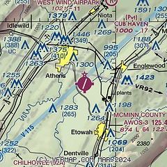
|
| Airport distance calculator |
|---|
|
|
| Sunrise and sunset |
|---|
|
Times for 09-Jan-2026
| | Local
(UTC-5) | | Zulu
(UTC) |
|---|
| Morning civil twilight | | 07:21 | | 12:21 |
| Sunrise | | 07:49 | | 12:49 |
| Sunset | | 17:42 | | 22:42 |
| Evening civil twilight | | 18:10 | | 23:10 |
|
| Current date and time |
|---|
| Zulu (UTC) | 09-Jan-2026 14:06:02 |
|---|
| Local (UTC-5) | 09-Jan-2026 09:06:02 |
|---|
|
| METAR |
|---|
| KMMI | 091355Z AUTO VRB05KT 10SM OVC036 19/13 A3008 RMK A01
|
KMNV
12nm NE | 091355Z AUTO 18010G20KT 10SM OVC036 19/15 A3007 RMK A01
|
KRZR
16nm SW | 091355Z AUTO 20012G21KT 10SM BKN060 OVC070 19/16 A3006 RMK A01
|
K2A0
19nm W | 091355Z AUTO 20010KT 10SM OVC019 18/16 A3005 RMK A01
|
|
| TAF |
|---|
KTYS
38nm NE | 091120Z 0912/1012 VRB03KT P6SM BKN050 WS020/20045KT FM091400 21010KT 6SM -SHRA OVC035 WS020/20040KT FM091800 21010G17KT 5SM -SHRA BR OVC020 TEMPO 0918/0922 4SM SHRA BR OVC009 FM092200 VRB04KT P6SM VCSH OVC009
|
KCHA
38nm SW | 091120Z 0912/1012 16012KT 5SM -SHRA BR OVC015 TEMPO 0919/0923 2SM SHRA OVC009 FM092300 18007KT P6SM VCSH BKN009
|
|
| NOTAMs |
|---|
NOTAMs are issued by the DoD/FAA and will open in a separate window not controlled by AirNav.
|
|

