FAA INFORMATION EFFECTIVE 14 MAY 2026
Location
| FAA Identifier: | MSL |
| Lat/Long: | 34-44-43.1000N 087-36-36.8000W
34-44.718333N 087-36.613333W
34.7453056,-87.6102222
(estimated) |
| Elevation: | 550.5 ft. / 167.8 m (surveyed) |
| Variation: | 03W (2015) |
| From city: | 1 mile E of MUSCLE SHOALS, AL |
| Time zone: | UTC -5 (UTC -6 during Standard Time) |
| Zip code: | 35661 |
Airport Operations
| Airport use: | Open to the public |
| Activation date: | 04/1940 |
| Control tower: | no |
| ARTCC: | MEMPHIS CENTER |
| FSS: | ANNISTON FLIGHT SERVICE STATION |
| NOTAMs facility: | MSL (NOTAM-D service available) |
| Attendance: | 0600-1800
EXC THANKSGIVING, CHRISTMAS, AND NEW YEARS DAY |
| Wind indicator: | lighted |
| Segmented circle: | yes |
| Lights: | ACTVT MALSR RWY 30; REIL RWY 12; PAPI RWY 12; PAPI RWY 18 & 36; HIRL RWY 12/30; MIRL RWY 18/36 - CTAF. |
| Beacon: | white-green (lighted land airport)
Operates sunset to sunrise. |
| Fire and rescue: | ARFF index A |
| Airline operations: | PPR FOR UNSKED ACR & CHTR OPNS WITH MORE THAN 30 PSGR SEATS; CALL AMGR (256) 381-2869, EXT 101 OR FAX (256) 381-2915. |
Airport Communications
| CTAF/UNICOM: | 123.05 |
| WX ASOS: | 119.425 (256-383-2304) |
| WX AWOS-3P at 9A4 (14 nm E): | 118.525 (256-637-0903) |
- APCH/DEP SVC PRVDD BY MEMPHIS ARTCC ON FREQS 120.8/307.0 (HUNTSVILLE RCAG).
Airport Services
| Fuel available: | 100LL JET-A
100LL:FUEL AVBL NIGHTS CALL 256-383-2270. AVGAS 100LL SELF SERVE AVBL 24 HRS. |
| Parking: | hangars and tiedowns |
| Airframe service: | NONE |
| Powerplant service: | NONE |
| Bottled oxygen: | NONE |
| Bulk oxygen: | NONE |
Runway Information
Runway 12/30
| Dimensions: | 6694 x 150 ft. / 2040 x 46 m |
| Surface: | asphalt/grooved, in good condition |
| Weight bearing capacity: | | Single wheel: | 59.0 | | Double wheel: | 98.0 | | Double tandem: | 160.0 |
|
| Runway edge lights: | high intensity |
| RUNWAY 12 | | RUNWAY 30 |
| Latitude: | 34-44.940455N | | 34-44.489840N |
| Longitude: | 087-37.020717W | | 087-35.800363W |
| Elevation: | 542.0 ft. | | 550.2 ft. |
| Traffic pattern: | left | | left |
| Runway heading: | 117 magnetic, 114 true | | 297 magnetic, 294 true |
| Markings: | precision, in good condition | | precision, in good condition |
| Visual slope indicator: | 4-light PAPI on right (3.00 degrees glide path) | | |
| Approach lights: | | | MALSR: 1,400 foot medium intensity approach lighting system with runway alignment indicator lights |
| Runway end identifier lights: | yes | | no |
| Touchdown point: | yes, no lights | | yes, no lights |
| Instrument approach: | | | ILS |
| Obstructions: | 52 ft. trees, 1689 ft. from runway, 269 ft. right of centerline, 28:1 slope to clear | | 68 ft. trees, 2004 ft. from runway, 530 ft. left of centerline, 26:1 slope to clear |
Runway 18/36
| Dimensions: | 4000 x 100 ft. / 1219 x 30 m |
| Surface: | asphalt, in fair condition |
| Weight bearing capacity: | | Single wheel: | 30.0 | | Double wheel: | 50.0 |
|
| Runway edge lights: | medium intensity |
| Operational restrictions: | RWY 18/36 NOT AVBL FOR PART 121/PART 380 OPS WITH SKED PAX CARRYING OPS MORE THAN 9 PAX SEATS AND NON-SKED PAX CARRYING OPS MORE THAN 30 PAX SEATS. |
| RUNWAY 18 | | RUNWAY 36 |
| Latitude: | 34-45.054495N | | 34-44.395243N |
| Longitude: | 087-36.943402W | | 087-36.962538W |
| Elevation: | 539.3 ft. | | 540.9 ft. |
| Traffic pattern: | left | | left |
| Runway heading: | 184 magnetic, 181 true | | 004 magnetic, 001 true |
| Markings: | nonprecision, in good condition | | nonprecision, in good condition |
| Visual slope indicator: | 4-light PAPI on left (3.00 degrees glide path) | | 4-light PAPI on left (3.00 degrees glide path) |
| Touchdown point: | yes, no lights | | yes, no lights |
| Obstructions: | 61 ft. tree, 906 ft. from runway, 283 ft. left of centerline, 11:1 slope to clear | | none |
Airport Ownership and Management from official FAA records
| Ownership: | Publicly-owned |
| Owner: | COLBERT & LAUDERDALE COUNTIES
1729 T. ED CAMPBELL DR SUITE A
MUSCLE SHOALS, AL 35661-2016
Phone 256-381-2869 |
| Manager: | BARRY GRIFFITH
1729 T. ED CAMPBELL DR SUITE A
MUSCLE SHOALS, AL 35661-2016
Phone 256-383-2270
EXT. 101. |
Additional Remarks
| A39-18/36 | PCR VALUE: 470/F/C/X/T |
| A39-12/30 | PCR VALUE: 430/F/B/X/T |
| A30A-30 | CALM WIND RWY. |
| - | FOR CD IF UNA VIA GCO CTC MEMPHIS ARTCC AT 901-368-8453/8449. |
| - | NO GA PARKING ON ACR RAMP. |
| - | LNDG FEE & PAX FAC CHRG FOR UNSKED ACR & CHTR OPNS. |
| - | TWY A IS THE PREF TWY FOR ACR & CHTR OPNS USING THE ACR RAMP. |
| - | LNDG FEE FOR ACR OVER 12,500 LBS. |
| - | GCO AVBL ON FREQ 121.725 FOR MEMPHIS ARTCC (ZME). |
Instrument Procedures
NOTE: All procedures below are presented as PDF files. If you need a reader for these files, you should download the free Adobe Reader.NOT FOR NAVIGATION. Please procure official charts for flight.
FAA instrument procedures published for use from 14 May 2026 at 0901Z to 11 June 2026 at 0900Z.
IAPs - Instrument Approach Procedures |
|---|
| ILS Y OR LOC Y RWY 30 **CHANGED** | |
download (250KB) |
| ILS Z OR LOC Z RWY 30 **CHANGED** | |
download (259KB) |
| RNAV (GPS) RWY 12 **CHANGED** | |
download (248KB) |
| RNAV (GPS) RWY 18 **CHANGED** | |
download (274KB) |
| RNAV (GPS) RWY 30 **CHANGED** | |
download (220KB) |
| RNAV (GPS) RWY 36 **CHANGED** | |
download (266KB) |
| NOTE: Special Alternate Minimums apply | |
download (158KB) |
| NOTE: Special Take-Off Minimums/Departure Procedures apply | |
download (499KB) |
Other nearby airports with instrument procedures:
9A4 - Courtland Airport (14 nm E)
M22 - Bill Pugh Field Airport (19 nm S)
15M - Segars Field Airport (27 nm W)
1M4 - Posey Field Airport (28 nm S)
KDCU - Pryor Field Regional Airport (33 nm E)
|
|

Road maps at:
MapQuest
Bing
Google
| Aerial photo |
|---|
WARNING: Photo may not be current or correct
 Photo courtesy of sellersphoto.com
Photo taken 07-Jun-2010
Photo courtesy of sellersphoto.com
Photo taken 07-Jun-2010
Do you have a better or more recent aerial photo of Northwest Alabama Regional Airport that you would like to share? If so, please send us your photo.
|
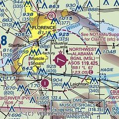
| Sectional chart |
|---|
|
CAUTION: Diagram may not be current

| Airport distance calculator |
|---|
|
|
| Sunrise and sunset |
|---|
|
Times for 21-May-2026
| | Local
(UTC-5) | | Zulu
(UTC) |
|---|
| Morning civil twilight | | 05:16 | | 10:16 |
| Sunrise | | 05:44 | | 10:44 |
| Sunset | | 19:50 | | 00:50 |
| Evening civil twilight | | 20:18 | | 01:18 |
|
| Current date and time |
|---|
| Zulu (UTC) | 21-May-2026 16:45:00 |
|---|
| Local (UTC-5) | 21-May-2026 11:45:00 |
|---|
|
| METAR |
|---|
| KMSL | 211639Z AUTO VRB03KT 10SM FEW018 BKN030 BKN080 24/20 A3004 RMK AO2 T02390200
|
K9A4
14nm E | 211635Z AUTO 00000KT 10SM OVC018 22/19 A3008 RMK AO2
|
|
| TAF |
|---|
| KMSL | 211120Z 2112/2212 VRB02KT 6SM -RA BR SCT010 OVC060 TEMPO 2112/2114 5SM -RA BR BKN007 OVC035 FM211400 14004KT P6SM VCSH BKN015 OVC040 FM211800 18006KT P6SM -SHRA BKN040 TEMPO 2120/2124 4SM TSRA BR BKN025CB FM220100 17005KT 6SM BR OVC015
|
|
| NOTAMs |
|---|
NOTAMs are issued by the DoD/FAA and will open in a separate window not controlled by AirNav.
|
|


