FAA INFORMATION EFFECTIVE 19 MARCH 2026
Location
| FAA Identifier: | MVN |
| Lat/Long: | 38-19-24.1000N 088-51-30.6000W
38-19.401667N 088-51.510000W
38.3233611,-88.8585000
(estimated) |
| Elevation: | 480.4 ft. / 146.4 m (surveyed) |
| Variation: | 01W (2000) |
| From city: | 3 miles E of MOUNT VERNON, IL |
| Time zone: | UTC -5 (UTC -6 during Standard Time) |
| Zip code: | 62864 |
Airport Operations
| Airport use: | Open to the public |
| Activation date: | 04/1940 |
| Control tower: | no |
| ARTCC: | KANSAS CITY CENTER |
| FSS: | SAINT LOUIS FLIGHT SERVICE STATION |
| NOTAMs facility: | MVN (NOTAM-D service available) |
| Attendance: | 0630-2000
FOR SVCS AFT HRS CALL 618-315-5462. |
| Wind indicator: | lighted |
| Segmented circle: | yes |
| Lights: | ACTVT MALSR RY 23 - CTAF. ACTVT MIRL RY 15/33 & HIRL RY 05/23 - CTAF NIGHT ONLY. |
| Beacon: | white-green (lighted land airport)
Operates sunset to sunrise. |
| Fire and rescue: | ARFF index A |
Airport Communications
| CTAF/UNICOM: | 123.0 |
| WX AWOS-3PT: | 118.2 (618-242-7933) |
| WX AWOS-3PT at ENL (16 nm NW): | 121.125 (618-533-4417) |
| WX AWOS-3PT at SLO (20 nm N): | 118.525 (618-312-1051) |
- APCH/DEP SVC PRVDD BY KANSAS CITY ARTCC ON FREQS 127.7/351.825 (MOUNT VERNON RCAG).
Nearby radio navigation aids
| VOR radial/distance | | VOR name | | Freq | | Var |
|---|
| ENLr108/15.3 | | CENTRALIA VORTAC | | 115.00 | | 04E |
| BIBr203/39.9 | | BIBLE GROVE VORTAC | | 109.00 | | 03E |
| NDB name | | Hdg/Dist | | Freq | | Var | | ID |
|---|
| WAYNE COUNTY | | 262/21.4 | | 257 | | 01W | | FWC | ..-. .-- -.-. |
| OLNEY | | 237/40.0 | | 272 | | 03W | | OLY | --- .-.. -.-- |
Airport Services
| Fuel available: | 100LL JET-A |
| Parking: | hangars and tiedowns |
| Airframe service: | MAJOR |
| Powerplant service: | MAJOR |
| Bulk oxygen: | LOW |
Runway Information
Runway 5/23
| Dimensions: | 6496 x 150 ft. / 1980 x 46 m |
| Surface: | asphalt/grooved, in good condition |
| Weight bearing capacity: | | Single wheel: | 120.0 | | Double wheel: | 177.0 | | Double tandem: | 238.0 | | Dual double tandem: | 678.0 |
|
| Runway edge lights: | high intensity |
| Operational restrictions: | RWY 05/23 NOT AVBL FOR PART 121/PART 380 OPS WITH SKED PAX CARRYING OPS MORE THAN 9 PAX SEATS AND NON-SKED PAX CARRYING OPS MORE THAN 30 PAX SEATS. 90 DAY PPR FOR UNSKED ACR OPS GTR THAN 30 PAX SEATS - CALL AMGR. 618-242-7016 |
| RUNWAY 5 | | RUNWAY 23 |
| Latitude: | 38-19.068833N | | 38-19.755840N |
| Longitude: | 088-52.005070W | | 088-50.963315W |
| Elevation: | 466.8 ft. | | 467.8 ft. |
| Traffic pattern: | left | | left |
| Runway heading: | 051 magnetic, 050 true | | 231 magnetic, 230 true |
| Displaced threshold: | 774 ft. | | no |
| Declared distances: | TORA:6496 TODA:6496 ASDA:6496 LDA:5722 | | TORA:5572 TODA:5572 ASDA:5572 LDA:5572 |
| Markings: | precision, in good condition | | precision, in good condition |
| Visual slope indicator: | 4-box VASI on left (3.00 degrees glide path) | | |
| Approach lights: | | | MALSR: 1,400 foot medium intensity approach lighting system with runway alignment indicator lights
RY 23 MALSR AVBL DALGT HRS. |
| Runway end identifier lights: | | | no |
| Touchdown point: | yes, no lights | | yes, no lights |
| Instrument approach: | | | ILS |
| Obstructions: | 12 ft. road, 200 ft. from runway, 395 ft. right of centerline
12 FT ROAD 0-200 FT FM THLD 395 FT R TO 495 FT R OF CNTRLN. | | 97 ft. trees, 2988 ft. from runway, 54 ft. left of centerline, 28:1 slope to clear |
Runway 15/33
| Dimensions: | 3146 x 100 ft. / 959 x 30 m |
| Surface: | asphalt/porous friction courses, in fair condition |
| Weight bearing capacity: | | Single wheel: | 55.0 | | Double wheel: | 72.0 | | Double tandem: | 121.0 |
|
| Runway edge lights: | medium intensity |
| Operational restrictions: | RWY 15/33 NOT AVBL FOR PART 121/PART 380 OPS WITH SKED PAX CARRYING OPS MORE THAN 9 PAX SEATS AND NON-SKED PAX CARRYING OPS MORE THAN 30 PAX SEATS. 90 DAY PPR FOR UNSKED ACR OPS GTR THAN 30 PAX SEATS - CALL AMGR. 618-242-7016 |
| RUNWAY 15 | | RUNWAY 33 |
| Latitude: | 38-19.601337N | | 38-19.152403N |
| Longitude: | 088-51.725823W | | 088-51.396875W |
| Elevation: | 480.4 ft. | | 457.0 ft. |
| Traffic pattern: | left | | left |
| Runway heading: | 151 magnetic, 150 true | | 331 magnetic, 330 true |
| Declared distances: | TORA:3146 TODA:3146 ASDA:3146 LDA:3146 | | TORA:3146 TODA:3146 ASDA:3146 LDA:3146 |
| Markings: | basic, in fair condition | | basic, in fair condition |
| Runway end identifier lights: | no | | |
| Touchdown point: | yes, no lights | | yes, no lights |
| Obstructions: | 63 ft. tree, 873 ft. from runway, 180 ft. left of centerline, 10:1 slope to clear | | 23 ft. rr, 613 ft. from runway, 166 ft. left of centerline, 19:1 slope to clear |
Helipad H1
| Dimensions: | 80 x 40 ft. / 24 x 12 m |
| Surface: | concrete |
| Runway edge lights: | PERI |
| Operational restrictions: | FOR PVT USE BY AIR-EVAC LIFETEAM ONLY. |
| Latitude: | 38-19.173167N | | |
| Longitude: | 088-51.117167W | | |
| Elevation: | 457.0 ft. | | |
| Traffic pattern: | left | | left |
Airport Ownership and Management from official FAA records
| Ownership: | Publicly-owned |
| Owner: | MT VERNON ARPT AUTHORITY
100 AVIATION DRIVE
MT VERNON, IL 62864
Phone 618-242-7016 |
| Manager: | CHRIS COLLINS
100 AVIATION DRIVE
MT VERNON, IL 62864
Phone 618-242-7016 |
Additional Remarks
| A39-05/23 | PCR VALUE: 550/F/D/X/T |
| A39-15/33 | PCR VALUE: 220/F/D/X/T |
| - | MIGRATORY WATERFOWL INVOF ARPT. |
| - | FOR CD CTC KANSAS CITY ARTCC AT 913-254-8508. |
Instrument Procedures
NOTE: All procedures below are presented as PDF files. If you need a reader for these files, you should download the free Adobe Reader.NOT FOR NAVIGATION. Please procure official charts for flight.
FAA instrument procedures published for use from 19 March 2026 at 0901Z to 16 April 2026 at 0900Z.
IAPs - Instrument Approach Procedures |
|---|
| ILS OR LOC RWY 23 | |
download (204KB) |
| RNAV (GPS) RWY 05 | |
download (265KB) |
| RNAV (GPS) RWY 23 | |
download (253KB) |
| NOTE: Special Alternate Minimums apply | |
download (141KB) |
| NOTE: Special Take-Off Minimums/Departure Procedures apply | |
download (201KB) |
Other nearby airports with instrument procedures:
KENL - Centralia Municipal Airport (16 nm NW)
H96 - Benton Municipal Airport (19 nm S)
KSLO - Salem-Leckrone Airport (20 nm N)
KFWC - Fairfield Municipal Airport (21 nm E)
KFOA - Flora Municipal Airport (28 nm NE)
|
|

Road maps at:
MapQuest
Bing
Google
| Aerial photo |
|---|
WARNING: Photo may not be current or correct
 Photo courtesy of AirNav, LLC
Photo taken 29-Apr-2011
looking southwest.
Photo courtesy of AirNav, LLC
Photo taken 29-Apr-2011
looking southwest.
Do you have a better or more recent aerial photo of Mount Vernon Airport that you would like to share? If so, please send us your photo.
|
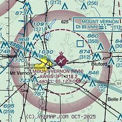
| Sectional chart |
|---|
|
| Airport distance calculator |
|---|
|
|
| Sunrise and sunset |
|---|
|
Times for 06-Apr-2026
| | Local
(UTC-5) | | Zulu
(UTC) |
|---|
| Morning civil twilight | | 06:07 | | 11:07 |
| Sunrise | | 06:34 | | 11:34 |
| Sunset | | 19:22 | | 00:22 |
| Evening civil twilight | | 19:49 | | 00:49 |
|
| Current date and time |
|---|
| Zulu (UTC) | 07-Apr-2026 03:10:40 |
|---|
| Local (UTC-5) | 06-Apr-2026 22:10:40 |
|---|
|
| METAR |
|---|
| KMVN | 070256Z AUTO VRB03KT 10SM BKN070 OVC110 11/M01 A3030 RMK AO2 SLP265 T01111006 53016 $
|
KENL
16nm NW | 070255Z AUTO 00000KT 10SM BKN070 BKN090 OVC110 11/02 A3030 RMK AO2 T01100019
|
|
| TAF |
|---|
| KMVN | 061720Z 0618/0718 31008KT P6SM SKC FM070000 36004KT P6SM SKC FM070600 04005KT P6SM SCT120 FM071400 06010KT P6SM BKN080
|
|
| NOTAMs |
|---|
NOTAMs are issued by the DoD/FAA and will open in a separate window not controlled by AirNav.
|
|


