FAA INFORMATION EFFECTIVE 11 JUNE 2026
Location
| FAA Identifier: | ENL |
| Lat/Long: | 38-30-54.3000N 089-05-28.1000W
38-30.905000N 089-05.468333W
38.5150833,-89.0911389
(estimated) |
| Elevation: | 534.1 ft. / 163 m (estimated) |
| Variation: | 02W (2010) |
| From city: | 2 miles SE of CENTRALIA, IL |
| Time zone: | UTC -5 (UTC -6 during Standard Time) |
| Zip code: | 62801 |
Airport Operations
| Airport use: | Open to the public |
| Activation date: | 04/1947 |
| Control tower: | no |
| ARTCC: | KANSAS CITY CENTER |
| FSS: | SAINT LOUIS FLIGHT SERVICE STATION |
| NOTAMs facility: | ENL (NOTAM-D service available) |
| Attendance: | 0800-DUSK
FOR SVC AFT HRS CALL (920) 728-4417. |
| Wind indicator: | lighted |
| Segmented circle: | yes |
| Lights: | ACTVT MIRL RY 09/27, RY 18/36 & REIL RY 18/36 - CTAF. |
| Beacon: | white-green (lighted land airport)
Operates sunset to sunrise. |
Airport Communications
| CTAF/UNICOM: | 122.8 |
| WX AWOS-3PT: | 121.125 (618-533-4417) |
| WX AWOS-3PT at SLO (10 nm NE): | 118.525 (618-312-1051) |
| WX AWOS-3PT at MVN (16 nm SE): | 118.2 (618-809-6024) |
- APCH/DEP SVC PRVDD BY KANSAS CITY ARTCC ON FREQS 127.7/351.825 (MOUNT VERNON RCAG).
Nearby radio navigation aids
| VOR radial/distance | | VOR name | | Freq | | Var |
|---|
| ENLr025/6.5 | | CENTRALIA VORTAC | | 115.00 | | 04E |
| BIBr227/37.5 | | BIBLE GROVE VORTAC | | 109.00 | | 03E |
| NDB name | | Hdg/Dist | | Freq | | Var | | ID |
|---|
| WAYNE COUNTY | | 285/33.0 | | 257 | | 01W | | FWC | ..-. .-- -.-. |
Airport Services
| Fuel available: | 100LL JET-A |
| Parking: | tiedowns |
| Bottled oxygen: | NONE |
| Bulk oxygen: | NONE |
Runway Information
Runway 18/36
| Dimensions: | 5001 x 75 ft. / 1524 x 23 m |
| Surface: | asphalt, in good condition |
| Weight bearing capacity: | | Single wheel: | 30.0 | | Double wheel: | 40.0 |
|
| Runway edge lights: | medium intensity |
| RUNWAY 18 | | RUNWAY 36 |
| Latitude: | 38-31.303925N | | 38-30.480175N |
| Longitude: | 089-05.495882W | | 089-05.507802W |
| Elevation: | 519.3 ft. | | 534.1 ft. |
| Traffic pattern: | left | | right |
| Runway heading: | 183 magnetic, 181 true | | 002 magnetic, 360 true |
| Markings: | nonprecision, in good condition | | nonprecision, in fair condition |
| Visual slope indicator: | 2-light PAPI on left (3.00 degrees glide path) | | 2-light PAPI on left (3.00 degrees glide path) |
| Runway end identifier lights: | yes | | yes |
| Touchdown point: | yes, no lights | | yes, no lights |
| Obstructions: | 49 ft. tree, 1608 ft. from runway, 56 ft. left of centerline, 28:1 slope to clear | | none |
Runway 9/27
| Dimensions: | 3300 x 60 ft. / 1006 x 18 m |
| Surface: | asphalt, in good condition |
| Weight bearing capacity: | |
| Runway edge lights: | medium intensity |
| Runway edge markings: | RWY 27 MARKINGS FADED. |
| RUNWAY 9 | | RUNWAY 27 |
| Latitude: | 38-30.912315N | | 38-30.939402N |
| Longitude: | 089-05.762397W | | 089-05.071330W |
| Elevation: | 521.9 ft. | | 519.9 ft. |
| Traffic pattern: | right | | left |
| Runway heading: | 089 magnetic, 087 true | | 269 magnetic, 267 true |
| Markings: | basic, in poor condition | | basic, in poor condition |
| Runway end identifier lights: | no | | no |
| Touchdown point: | yes, no lights | | yes, no lights |
| Obstructions: | 13 ft. road, 470 ft. from runway, 20:1 slope to clear | | none |
Airport Ownership and Management from official FAA records
| Ownership: | Publicly-owned |
| Owner: | CITY OF CENTRALIA
101 S. LOCUST
CENTRALIA, IL 62801
Phone (618) 533-7622 |
| Manager: | GALEN MAHLE
2331 E. CALUMET
CENTRALIA, IL 62801
Phone 618-533-7622
CELL # 618-267-7844 |
Additional Remarks
| - | FOR CD IF UNA TO CTC ON FSS FREQ, CTC KANSAS CITY ARTCC AT 913-254-8508. |
Instrument Procedures
NOTE: All procedures below are presented as PDF files. If you need a reader for these files, you should download the free Adobe Reader.NOT FOR NAVIGATION. Please procure official charts for flight.
FAA instrument procedures published for use from 11 June 2026 at 0901Z to 09 July 2026 at 0900z.
IAPs - Instrument Approach Procedures |
|---|
| RNAV (GPS) RWY 18 **CHANGED** | |
download (192KB) |
| RNAV (GPS) RWY 36 **CHANGED** | |
download (197KB) |
| NOTE: Special Take-Off Minimums/Departure Procedures apply | |
download (201KB) |
Other nearby airports with instrument procedures:
KSLO - Salem-Leckrone Airport (10 nm NE)
KMVN - Mount Vernon Airport (16 nm SE)
KGRE - Greenville Airport (24 nm NW)
KVLA - Vandalia Municipal Airport (29 nm N)
KFOA - Flora Municipal Airport (31 nm E)
|
|

Road maps at:
MapQuest
Bing
Google
| Aerial photo |
|---|
WARNING: Photo may not be current or correct
 Photo by David Newcomer
Photo taken 22-Sep-2011
from 3,000' AGL looking north.
Photo by David Newcomer
Photo taken 22-Sep-2011
from 3,000' AGL looking north.
Do you have a better or more recent aerial photo of Centralia Municipal Airport that you would like to share? If so, please send us your photo.
|
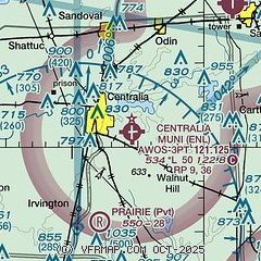
| Sectional chart |
|---|
|
| Airport distance calculator |
|---|
|
|
| Sunrise and sunset |
|---|
|
Times for 27-Jun-2026
| | Local
(UTC-5) | | Zulu
(UTC) |
|---|
| Morning civil twilight | | 05:03 | | 10:03 |
| Sunrise | | 05:35 | | 10:35 |
| Sunset | | 20:24 | | 01:24 |
| Evening civil twilight | | 20:55 | | 01:55 |
|
| Current date and time |
|---|
| Zulu (UTC) | 28-Jun-2026 03:12:27 |
|---|
| Local (UTC-5) | 27-Jun-2026 22:12:27 |
|---|
|
| METAR |
|---|
| KENL | 280235Z AUTO 00000KT 10SM SCT036 25/23 A2991 RMK AO2 T02470232
|
KSLO
10nm NE | 280255Z 10SM SCT029 SCT035 25/25 A2991 RMK AO2 T02460246
|
KMVN
16nm SE | 280256Z AUTO 00000KT 10SM CLR 24/22 A2991 RMK AO2 SLP126 P0005 60020 T02390222 50003 $
|
|
| TAF |
|---|
KMVN
16nm SE | 280204Z 2802/2824 VRB03KT P6SM SCT005 BKN100 PROB30 2805/2811 4SM -TSRA BR BKN005CB FM281400 21006KT P6SM SCT015 FM281700 20008KT P6SM SCT030
|
|
| NOTAMs |
|---|
NOTAMs are issued by the DoD/FAA and will open in a separate window not controlled by AirNav.
|
|

