FAA INFORMATION EFFECTIVE 14 MAY 2026
Location
| FAA Identifier: | MWK |
| Lat/Long: | 36-27-40.9020N 080-33-11.5570W
36-27.681700N 080-33.192617W
36.4613617,-80.5532103
(estimated) |
| Elevation: | 1268.9 ft. / 386.8 m (surveyed) |
| Variation: | 07W (1995) |
| From city: | 3 miles SE of MOUNT AIRY, NC |
| Time zone: | UTC -4 (UTC -5 during Standard Time) |
| Zip code: | 27030 |
Airport Operations
| Airport use: | Open to the public |
| Activation date: | 01/1968 |
| Control tower: | no |
| ARTCC: | ATLANTA CENTER |
| FSS: | RALEIGH FLIGHT SERVICE STATION |
| NOTAMs facility: | MWK (NOTAM-D service available) |
| Attendance: | ALL/ALL/
0800- (EARLIER OF) 1800 LOCAL OR SS. |
| Wind indicator: | lighted |
| Segmented circle: | yes |
| Lights: | ACTVT REIL RWY 18 & 36; PAPI RWY 18 & 36; MIRL RWY 18/36 - CTAF. |
| Beacon: | white-green (lighted land airport)
Operates sunset to sunrise. |
Airport Communications
| CTAF/UNICOM: | 123.0 |
| WX AWOS-3PT: | 121.125 (336-789-2299) |
| GREENSBORO APPROACH: | 124.35 |
| GREENSBORO DEPARTURE: | 124.35 |
Nearby radio navigation aids
| VOR radial/distance | | VOR name | | Freq | | Var |
|---|
| GSOr315/37.4 | | GREENSBORO VORTAC | | 116.20 | | 03W |
| PSKr174/38.4 | | PULASKI VORTAC | | 116.80 | | 06W |
| NDB name | | Hdg/Dist | | Freq | | Var | | ID |
|---|
| SLAMMER | | 284/38.5 | | 423 | | 07W | | SIF | ... .. ..-. |
Airport Services
| Fuel available: | 100LL JET-A JET-A1+ |
| Parking: | hangars and tiedowns |
| Airframe service: | MAJOR |
| Powerplant service: | MAJOR |
| Bottled oxygen: | NONE |
| Bulk oxygen: | NONE |
Runway Information
Runway 18/36
| Dimensions: | 5500 x 75 ft. / 1676 x 23 m |
| Surface: | asphalt, in excellent condition |
| Weight bearing capacity: | | PCN 8 /F/B/X/T | | Single wheel: | 27.0 | | Double wheel: | 42.0 |
|
| Runway edge lights: | medium intensity |
| RUNWAY 18 | | RUNWAY 36 |
| Latitude: | 36-28.131702N | | 36-27.231712N |
| Longitude: | 080-33.258470W | | 080-33.126773W |
| Elevation: | 1268.9 ft. | | 1208.5 ft. |
| Traffic pattern: | left | | left |
| Runway heading: | 180 magnetic, 173 true | | 000 magnetic, 353 true |
| Markings: | nonprecision, in good condition | | nonprecision, in good condition |
| Visual slope indicator: | 4-light PAPI on right (3.00 degrees glide path) | | 4-light PAPI on left (3.00 degrees glide path) |
| Runway end identifier lights: | yes | | yes |
| Touchdown point: | yes, no lights | | yes, no lights |
| Obstructions: | 47 ft. trees, 1219 ft. from runway, 275 ft. left of centerline, 21:1 slope to clear | | 63 ft. other, 1842 ft. from runway, 32 ft. left of centerline, 26:1 slope to clear |
Airport Ownership and Management from official FAA records
| Ownership: | Publicly-owned |
| Owner: | CITY OF MOUNT AIRY & SURRY COUNTY
146 HOWARD WOLTZ JR. WAY
MOUNT AIRY, NC 27030-9020
Phone 336-401-8201 |
| Manager: | GEORGE CRATER
146 HOWARD WOLTZ JR. WAY
MOUNT AIRY, NC 27030-9020
Phone 336-789-5153 |
Additional Remarks
| - | RWY 36 SLOPES UPHILL 34 FEET. |
| - | AFTER HOURS SERVICE AVAILABLE/POSTED ON PHONE BOX. |
| - | RWY 36 - 50 FT DROP-OFF 300 FT FM THR AND 150 FT RIGHT & LEFT OF CNTRLN. |
| - | FOR CD CTC GREENSBORO APCH AT 743-222-6129. |
| - | RWY HAS 100 FT DROP-OFFS 90 FT FM CNTRLN BOTH SIDES AND 300 FT FM THR. |
Instrument Procedures
NOTE: All procedures below are presented as PDF files. If you need a reader for these files, you should download the free Adobe Reader.NOT FOR NAVIGATION. Please procure official charts for flight.
FAA instrument procedures published for use from 14 May 2026 at 0901Z to 11 June 2026 at 0900Z.
IAPs - Instrument Approach Procedures |
|---|
| RNAV (GPS) RWY 18 **CHANGED** | |
download (236KB) |
| RNAV (GPS) RWY 36 **CHANGED** | |
download (221KB) |
| NOTE: Special Alternate Minimums apply | |
download (155KB) |
| NOTE: Special Take-Off Minimums/Departure Procedures apply | |
download (142KB) |
Other nearby airports with instrument procedures:
KZEF - Elkin Municipal Airport (16 nm SW)
N63 - Meadow Brook Field Airport (22 nm SE)
KHLX - Twin County Airport (22 nm NW)
KINT - Smith Reynolds Airport (25 nm SE)
KMTV - Blue Ridge Airport (28 nm E)
|
|

Road maps at:
MapQuest
Bing
Google
| Aerial photo |
|---|
WARNING: Photo may not be current or correct
 Photo by Grant Gordon of Plane Fun Aviation, LLC
Photo taken 05-May-2012
looking north.
Photo by Grant Gordon of Plane Fun Aviation, LLC
Photo taken 05-May-2012
looking north.
Do you have a better or more recent aerial photo of Mount Airy/Surry County Airport that you would like to share? If so, please send us your photo.
|
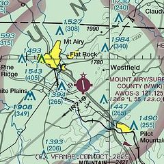
| Sectional chart |
|---|
|
| Airport distance calculator |
|---|
|
|
| Sunrise and sunset |
|---|
|
Times for 01-Jun-2026
| | Local
(UTC-4) | | Zulu
(UTC) |
|---|
| Morning civil twilight | | 05:37 | | 09:37 |
| Sunrise | | 06:07 | | 10:07 |
| Sunset | | 20:34 | | 00:34 |
| Evening civil twilight | | 21:03 | | 01:03 |
|
| Current date and time |
|---|
| Zulu (UTC) | 02-Jun-2026 03:48:08 |
|---|
| Local (UTC-4) | 01-Jun-2026 23:48:08 |
|---|
|
| METAR |
|---|
| KMWK | 020335Z AUTO 08007KT 10SM SCT075 OVC100 21/09 A3007 RMK AO2
|
|
| TAF |
|---|
KINT
26nm SE | 011720Z 0118/0218 36010KT P6SM BKN050 BKN250 FM012100 04010KT P6SM SCT050 BKN250 FM020600 06009KT P6SM BKN040 FM021600 06012KT P6SM SCT040 BKN120 AMD NOT SKED
|
|
| NOTAMs |
|---|
NOTAMs are issued by the DoD/FAA and will open in a separate window not controlled by AirNav.
|
|

