FAA INFORMATION EFFECTIVE 11 JUNE 2026
Location
| FAA Identifier: | ODO |
| Lat/Long: | 31-55-17.0946N 102-23-13.6783W
31-55.284910N 102-23.227972W
31.9214152,-102.3871329
(estimated) |
| Elevation: | 3003.6 ft. / 915.5 m (surveyed) |
| Variation: | 08E (2000) |
| From city: | 5 miles NE of ODESSA, TX |
| Time zone: | UTC -5 (UTC -6 during Standard Time) |
| Zip code: | 79765 |
Airport Operations
| Airport use: | Open to the public |
| Activation date: | 11/1945 |
| Control tower: | no |
| ARTCC: | FORT WORTH CENTER |
| FSS: | SAN ANGELO FLIGHT SERVICE STATION |
| NOTAMs facility: | ODO (NOTAM-D service available) |
| Attendance: | 0600-2000 |
| Wind indicator: | lighted |
| Segmented circle: | yes |
| Lights: | MIRL RWYS 02/20, 11/29, 16/34 PRESET LOW; TO INCR INTST - CTAF. |
| Beacon: | white-green (lighted land airport)
Operates sunset to sunrise. |
Airport Communications
| CTAF/UNICOM: | 123.0 |
| WX ASOS: | 119.275 (432-363-9719) |
| MIDLAND APPROACH: | 124.6 |
| MIDLAND DEPARTURE: | 124.6 |
| CLEARANCE DELIVERY: | 121.7 |
| WX ASOS at MAF (10 nm E): | PHONE 432-201-2813 |
| WX AWOS-3 at MDD (16 nm NE): | 118.125 (432-687-4605) |
- APCH/DEP SVC PRVDD BY FORT WORTH ARTCC (ZFW) ON FREQS 133.1/298.95 (MIDLAND RCAG) WHEN MIDLAND APCH CLSD.
Nearby radio navigation aids
| VOR radial/distance | | VOR name | | Freq | | Var |
|---|
| MAFr231/11.3 | | MIDLAND VORTAC | | 112.60 | | 11E |
| NDB name | | Hdg/Dist | | Freq | | Var | | ID |
|---|
| FARLY | | 209/5.1 | | 326 | | 09E | | MA | -- .- |
Airport Services
| Fuel available: | 100LL JET-A
100LL:FOR FUEL AFT HRS CALL 432-367-5881 OR SELF SERVE. |
| Parking: | hangars and tiedowns |
| Airframe service: | MAJOR |
| Powerplant service: | MAJOR |
| Bottled oxygen: | LOW |
Runway Information
Runway 11/29
| Dimensions: | 6200 x 100 ft. / 1890 x 30 m |
| Surface: | asphalt, in good condition |
| Weight bearing capacity: | |
| Runway edge lights: | medium intensity |
| RUNWAY 11 | | RUNWAY 29 |
| Latitude: | 31-55.578500N | | 31-55.055833N |
| Longitude: | 102-23.613000W | | 102-22.582500W |
| Elevation: | 2973.5 ft. | | 2979.5 ft. |
| Traffic pattern: | left | | left |
| Runway heading: | 113 magnetic, 121 true | | 293 magnetic, 301 true |
| Markings: | nonprecision, in good condition | | nonprecision, in good condition |
| Visual slope indicator: | 4-light PAPI on left (3.00 degrees glide path) | | 4-light PAPI on left (3.00 degrees glide path) |
| Approach lights: | MALS: 1,400 foot medium intensity approach lighting system | | MALS: 1,400 foot medium intensity approach lighting system |
| Touchdown point: | yes, no lights | | yes, no lights |
| Obstructions: | 75 ft. other, 2500 ft. from runway, 275 ft. left of centerline, 30:1 slope to clear
75 FT BILLBOARD; ALSO 50 FT MKD & LGTD PLINE, 2070 FT FM RWY END 37:1. | | 30 ft. pline, marked, 1350 ft. from runway, 246 ft. left of centerline, 38:1 slope to clear |
Runway 2/20
| Dimensions: | 5703 x 75 ft. / 1738 x 23 m |
| Surface: | asphalt, in good condition |
| Weight bearing capacity: | |
| Runway edge lights: | medium intensity |
| RUNWAY 2 | | RUNWAY 20 |
| Latitude: | 31-54.843970N | | 31-55.661145N |
| Longitude: | 102-23.560518W | | 102-23.014755W |
| Elevation: | 2952.4 ft. | | 3003.6 ft. |
| Traffic pattern: | left | | left |
| Runway heading: | 022 magnetic, 030 true | | 202 magnetic, 210 true |
| Markings: | nonprecision, in good condition | | nonprecision, in good condition |
| Visual slope indicator: | 2-light PAPI on left (3.00 degrees glide path) | | 2-light PAPI on left (3.00 degrees glide path) |
| Touchdown point: | yes, no lights | | yes, no lights |
| Obstructions: | 15 ft. road, 500 ft. from runway, 270 ft. left of centerline, 20:1 slope to clear | | 30 ft. pline, 1220 ft. from runway, 310 ft. right of centerline, 34:1 slope to clear |
Runway 16/34
| Dimensions: | 5003 x 75 ft. / 1525 x 23 m |
| Surface: | asphalt, in excellent condition |
| Weight bearing capacity: | |
| Runway edge lights: | medium intensity |
| RUNWAY 16 | | RUNWAY 34 |
| Latitude: | 31-55.679625N | | 31-54.884007N |
| Longitude: | 102-23.449183W | | 102-23.193495W |
| Elevation: | 2986.6 ft. | | 2958.2 ft. |
| Traffic pattern: | left | | left |
| Runway heading: | 157 magnetic, 165 true | | 337 magnetic, 345 true |
| Markings: | nonprecision, in good condition | | nonprecision, in good condition |
| Visual slope indicator: | 2-light PAPI on left (4.00 degrees glide path) | | 2-light PAPI on left (4.00 degrees glide path) |
| Touchdown point: | yes, no lights | | yes, no lights |
| Obstructions: | 45 ft. ant, 1104 ft. from runway, 120 ft. left of centerline, 20:1 slope to clear | | 30 ft. pline, marked, 960 ft. from runway, 250 ft. both sides of centerline, 25:1 slope to clear |
Airport Ownership and Management from official FAA records
| Ownership: | Publicly-owned |
| Owner: | ECTOR COUNTY
ECTOR CO COURTHOUSE ANNEX, 1010 EAST 8TH ST
ODESSA, TX 79761
Phone 432-498-4100 |
| Manager: | JON CRAIN
200 EAST TERMINAL DR
ODESSA, TX 79765
Phone 432-367-5881 |
Additional Remarks
| - | FOR CD WHEN 121.7 IS OTS CTC MIDLAND APCH AT 432-563-2123. WHEN APCH CLSD CTC FORT WORTH ARTCC AT 817-858-7584. |
| - | WILDLIFE ACTVY ON AND INVOF ARPT. |
| - | RWY 11, 170 FT LGTD TWR, 2500 FT NW OF RWY 11 END. |
| - | (CONTACT PHONE NR) WKENWORTHY54@GMAIL.COM |
Instrument Procedures
NOTE: All procedures below are presented as PDF files. If you need a reader for these files, you should download the free Adobe Reader.NOT FOR NAVIGATION. Please procure official charts for flight.
FAA instrument procedures published for use from 11 June 2026 at 0901Z to 09 July 2026 at 0900z.
IAPs - Instrument Approach Procedures |
|---|
| RNAV (GPS) RWY 11 | |
download (258KB) |
| RNAV (GPS) RWY 20 | |
download (217KB) |
| RNAV (GPS) RWY 29 | |
download (265KB) |
| NOTE: Special Alternate Minimums apply **CHANGED** | |
download (139KB) |
| NOTE: Special Take-Off Minimums/Departure Procedures apply | |
download (294KB) |
Other nearby airports with instrument procedures:
KMAF - Midland International Air and Space Port Airport (10 nm E)
KMDD - Midland Airpark (16 nm NE)
E11 - Andrews County Airport (26 nm N)
E01 - Roy Hurd Memorial Airport (34 nm SW)
KINK - Winkler County Airport (42 nm W)
|
|

Road maps at:
MapQuest
Bing
Google
| Aerial photo |
|---|
WARNING: Photo may not be current or correct
 Photo by John Hyle
Taken mid September 2008
Photo by John Hyle
Taken mid September 2008
Do you have a better or more recent aerial photo of Odessa Airport-Schlemeyer Field that you would like to share? If so, please send us your photo.
|
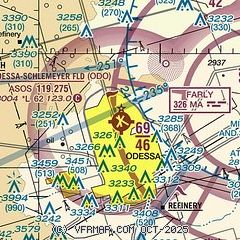
| Sectional chart |
|---|
|
| Airport distance calculator |
|---|
|
|
| Sunrise and sunset |
|---|
|
Times for 30-Jun-2026
| | Local
(UTC-5) | | Zulu
(UTC) |
|---|
| Morning civil twilight | | 06:20 | | 11:20 |
| Sunrise | | 06:48 | | 11:48 |
| Sunset | | 20:58 | | 01:58 |
| Evening civil twilight | | 21:27 | | 02:27 |
|
| Current date and time |
|---|
| Zulu (UTC) | 30-Jun-2026 19:22:54 |
|---|
| Local (UTC-5) | 30-Jun-2026 14:22:54 |
|---|
|
| METAR |
|---|
| KODO | 301853Z AUTO 18016G24KT 10SM CLR 32/18 A3000 RMK AO2 PK WND 19029/1825 SLP104 T03220183 $
|
KMAF
10nm E | 301853Z 17013G23KT 8SM FEW050 33/18 A2998 RMK AO2 SLP097 T03280183
|
KMDD
16nm NE | 301855Z AUTO 20014G21KT 10SM SCT050 33/18 A3000 RMK AO2 T03260175
|
|
| TAF |
|---|
KMAF
10nm E | 301727Z 3018/0118 18018KT P6SM SCT250 FM301900 17021G32KT P6SM FEW060 FM010200 15014KT P6SM SCT200
|
|
| NOTAMs |
|---|
NOTAMs are issued by the DoD/FAA and will open in a separate window not controlled by AirNav.
|
|


