FAA INFORMATION EFFECTIVE 11 JUNE 2026
Location
| FAA Identifier: | PRG |
| Lat/Long: | 39-41-58.8000N 087-40-14.8000W
39-41.980000N 087-40.246667W
39.6996667,-87.6707778
(estimated) |
| Elevation: | 654.2 ft. / 199.4 m (surveyed) |
| Variation: | 04W (2020) |
| From city: | 5 miles N of PARIS, IL |
| Time zone: | UTC -5 (UTC -6 during Standard Time) |
| Zip code: | 61944 |
Airport Operations
| Airport use: | Open to the public |
| Activation date: | 04/1975 |
| Control tower: | no |
| ARTCC: | INDIANAPOLIS CENTER |
| FSS: | SAINT LOUIS FLIGHT SERVICE STATION |
| NOTAMs facility: | PRG (NOTAM-D service available) |
| Attendance: | MON-FRI 0800-1600, ALL SAT 0800-1400, ALL SUN ON CALL |
| Pattern altitude: | 1454.2 ft. MSL |
| Wind indicator: | lighted |
| Segmented circle: | yes |
| Lights: | MIRL RY 09/27 PRESET ON LOW INTST; TO INCR INTST & ACTVT PSIL RYS 09 & 27, MIRL PSIL, RYS 18 & 36 - CTAF. |
| Beacon: | white-green (lighted land airport)
Operates sunset to sunrise. |
Airport Communications
| CTAF/UNICOM: | 123.0 |
| WX AWOS-3: | 124.175 (217-465-4304) |
| HULMAN APPROACH: | 125.45 134.725 [0530-2230] |
| HULMAN DEPARTURE: | 125.45 134.725 [0530-2230] |
Nearby radio navigation aids
| VOR radial/distance | | VOR name | | Freq | | Var |
|---|
| TTHr301/23.2 | | TERRE HAUTE VORTAC | | 115.30 | | 02E |
| CMIr123/34.4 | | CHAMPAIGN VORTAC | | 115.75 | | 03E |
| NDB name | | Hdg/Dist | | Freq | | Var | | ID |
|---|
| CRAWFORDSVILLE | | 248/38.7 | | 388 | | 04W | | CFJ | -.-. ..-. .--- |
Airport Services
| Fuel available: | 100LL JET-A |
| Parking: | hangars and tiedowns |
| Bottled oxygen: | NONE |
| Bulk oxygen: | NONE |
Runway Information
Runway 9/27
| Dimensions: | 4501 x 75 ft. / 1372 x 23 m |
| Surface: | asphalt, in fair condition |
| Weight bearing capacity: | |
| Runway edge lights: | medium intensity |
| Runway edge markings: | RWY 27 MARKINGS FADED. |
| RUNWAY 9 | | RUNWAY 27 |
| Latitude: | 39-41.998437N | | 39-42.020747N |
| Longitude: | 087-40.657358W | | 087-39.698123W |
| Elevation: | 654.0 ft. | | 650.7 ft. |
| Traffic pattern: | left | | left |
| Runway heading: | 092 magnetic, 088 true | | 272 magnetic, 268 true |
| Markings: | nonprecision, in poor condition | | nonprecision, in poor condition |
| Visual slope indicator: | pulsating/steady burning VASI on left (3.00 degrees glide path)
UNUSBL BYD 5 DEG LEFT/RIGHT OF CNTRLN. | | pulsating/steady burning VASI on left (3.15 degrees glide path)
UNUSBL BYD 5 DEG LEFT/RIGHT OF CNTRLN. |
| Runway end identifier lights: | no | | yes |
| Touchdown point: | yes, no lights | | yes, no lights |
Runway 18/36
| Dimensions: | 3200 x 75 ft. / 975 x 23 m |
| Surface: | asphalt |
| Runway edge lights: | medium intensity |
| RUNWAY 18 | | RUNWAY 36 |
| Latitude: | 39-42.203100N | | 39-41.676293N |
| Longitude: | 087-40.351975W | | 087-40.331410W |
| Elevation: | 645.2 ft. | | 654.0 ft. |
| Traffic pattern: | left | | left |
| Runway heading: | 182 magnetic, 178 true | | 002 magnetic, 358 true |
| Markings: | nonprecision, in fair condition | | nonprecision, in fair condition |
| Visual slope indicator: | pulsating/steady burning VASI on left (3.00 degrees glide path)
UNUSBL BYD 5 DEG LEFT/RIGHT OF CNTRLN. | | pulsating/steady burning VASI on left (3.00 degrees glide path)
UNUSBL BYD 5 DEG LEFT/RIGHT OF CNTRLN. |
| Runway end identifier lights: | no | | no |
| Touchdown point: | yes, no lights | | yes, no lights |
| Obstructions: | 45 ft. tree, 1141 ft. from runway, 20:1 slope to clear | | none |
Airport Ownership and Management from official FAA records
| Ownership: | Publicly-owned |
| Owner: | SUP BOARD OF EDGAR CO
15551 ARPT RD
PARIS, IL 61944-1944
Phone (217) 466-7433 |
| Manager: | TOM TUTTLE
15551 ARPT RD
PARIS, IL 61944-1944
Phone 217-465-8474 |
Additional Remarks
| - | FOR CD CTC HULMAN APCH AT 812-877-7581. |
Instrument Procedures
NOTE: All procedures below are presented as PDF files. If you need a reader for these files, you should download the free Adobe Reader.NOT FOR NAVIGATION. Please procure official charts for flight.
FAA instrument procedures published for use from 11 June 2026 at 0901Z to 09 July 2026 at 0900z.
IAPs - Instrument Approach Procedures |
|---|
| RNAV (GPS) RWY 09 | |
download (212KB) |
| RNAV (GPS) RWY 18 | |
download (196KB) |
| RNAV (GPS) RWY 27 | |
download (216KB) |
| RNAV (GPS) RWY 36 | |
download (207KB) |
| NOTE: Special Alternate Minimums apply | |
download (149KB) |
| NOTE: Special Take-Off Minimums/Departure Procedures apply | |
download (319KB) |
Other nearby airports with instrument procedures:
3I3 - Sky King Airport (16 nm SE)
KHUF - Terre Haute Regional Airport (23 nm SE)
1H8 - Casey Municipal Airport (28 nm SW)
0I2 - Brazil Clay County Airport/Charles B Hall Field (30 nm SE)
KDNV - Vermilion Regional Airport (30 nm N)
|
|

Road maps at:
MapQuest
Bing
Google
| Aerial photo |
|---|
WARNING: Photo may not be current or correct
 Photo by Sara Gradwohl
Photo taken 12-Aug-2013
looking southwest.
Photo by Sara Gradwohl
Photo taken 12-Aug-2013
looking southwest.
Do you have a better or more recent aerial photo of Edgar County Airport that you would like to share? If so, please send us your photo.
|
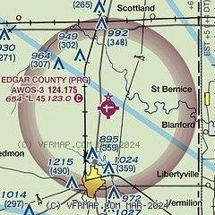
| Sectional chart |
|---|
|
| Airport distance calculator |
|---|
|
|
| Sunrise and sunset |
|---|
|
Times for 01-Jul-2026
| | Local
(UTC-5) | | Zulu
(UTC) |
|---|
| Morning civil twilight | | 04:55 | | 09:55 |
| Sunrise | | 05:27 | | 10:27 |
| Sunset | | 20:21 | | 01:21 |
| Evening civil twilight | | 20:54 | | 01:54 |
|
| Current date and time |
|---|
| Zulu (UTC) | 01-Jul-2026 16:03:13 |
|---|
| Local (UTC-5) | 01-Jul-2026 11:03:13 |
|---|
|
| METAR |
|---|
| KPRG | 011555Z AUTO 22003KT 10SM CLR 31/25 A3008 RMK AO2 T03120247
|
|
| TAF |
|---|
KHUF
22nm SE | 011120Z 0112/0212 19007KT P6SM SKC TEMPO 0112/0113 1SM BR BKN003 FM011600 21008KT P6SM SKC
|
|
| NOTAMs |
|---|
NOTAMs are issued by the DoD/FAA and will open in a separate window not controlled by AirNav.
|
|

