FAA INFORMATION EFFECTIVE 09 JULY 2026
Location
| FAA Identifier: | RCV |
| Lat/Long: | 37-42-49.6217N 106-21-07.2666W
37-42.827028N 106-21.121110W
37.7137838,-106.3520185
(estimated) |
| Elevation: | 7955.4 ft. / 2424.8 m (surveyed) |
| Variation: | 08E (2020) |
| From city: | 3 miles N of DEL NORTE, CO |
| Time zone: | UTC -6 (UTC -7 during Standard Time) |
| Zip code: | 81132 |
Airport Operations
| Airport use: | Open to the public |
| Activation date: | 05/1947 |
| Control tower: | no |
| ARTCC: | DENVER CENTER |
| FSS: | DENVER FLIGHT SERVICE STATION |
| NOTAMs facility: | DEN (NOTAM-D service available) |
| Attendance: | UNATNDD |
| Wind indicator: | yes |
| Segmented circle: | yes |
| Lights: | ACTVT REIL RWY 06 & 24, PAPI RWY 06 & 24, MIRL RWY 06/24 - CTAF. REIL RWY 06 & 24 ONLY OPR AT NGT. |
| Beacon: | white-green (lighted land airport)
Operates sunset to sunrise. |
Airport Communications
| CTAF: | 122.9 |
| WX AWOS-3PT: | 118.275 (719-657-9017) |
- APCH/DEP CTL SVC PRVDD BY DENVER ARTCC (ZDV) ON 128.375/379.95 (ALAMOSA RCAG).
Nearby radio navigation aids
| VOR radial/distance | | VOR name | | Freq | | Var |
|---|
| ALSr298/33.6 | | ALAMOSA VORTAC | | 113.90 | | 13E |
Airport Services
| Fuel available: | 100LL JET-A+
A+:FUEL AVBLTY: 100LL 24 HRS WITH CC; JET A+ BY APNTMT, CTC AMGR 719-221-6677. |
| Parking: | tiedowns |
Runway Information
Runway 6/24
| Dimensions: | 6051 x 75 ft. / 1844 x 23 m |
| Surface: | asphalt, in good condition |
| Runway edge lights: | medium intensity |
| RUNWAY 6 | | RUNWAY 24 |
| Latitude: | 37-42.513775N | | 37-42.895895N |
| Longitude: | 106-21.745895W | | 106-20.587317W |
| Elevation: | 7955.4 ft. | | 7889.6 ft. |
| Traffic pattern: | right | | left |
| Runway heading: | 059 magnetic, 067 true | | 239 magnetic, 247 true |
| Markings: | nonprecision, in good condition | | nonprecision, in good condition |
| Visual slope indicator: | 2-light PAPI on left (4.00 degrees glide path)
UNUSBL BYD 5 DEG RIGHT OF CRS. | | 2-light PAPI on left (3.00 degrees glide path) |
| Runway end identifier lights: | yes | | yes |
| Touchdown point: | yes, no lights | | yes, no lights |
Runway 3/21
| Dimensions: | 4812 x 60 ft. / 1467 x 18 m |
| Surface: | turf, in poor condition
NMRS HOLES FIRST 500 FT RWY 03; ROUGH SFC THRUT. |
| RUNWAY 3 | | RUNWAY 21 |
| Latitude: | 37-42.667628N | | 37-43.293742N |
| Longitude: | 106-21.369760W | | 106-20.758040W |
| Elevation: | 7925.9 ft. | | 7932.1 ft. |
| Traffic pattern: | left | | left |
| Runway heading: | 030 magnetic, 038 true | | 210 magnetic, 218 true |
| Touchdown point: | yes, no lights | | yes, no lights |
| Obstructions: | none | | 19 ft. road, 122 ft. from runway, 57 ft. right of centerline, 6:1 slope to clear |
Airport Ownership and Management from official FAA records
| Ownership: | Publicly-owned |
| Owner: | RIO GRANDE COUNTY
925 6TH STREET, RM 207
DEL NORTE, CO 81132
Phone 719-657-2744 |
| Manager: | BRIAN BURRELL
1 BRAVO TAXIWAY
DEL NORTE, CO 81132
Phone 719-221-6677 |
Additional Remarks
| A30A-21 | +8 FT SIGN 20 FT FM THR 10 FT R OF CNTRLN. |
| - | WILDLIFE ON & INVOF ARPT. |
| - | FOR CD CTC DENVER ARTCC AT 303-651-4257. |
| - | UNL VEHICLE ACES ON ARPT. |
| - | MTUS TRRN ALL QUADS. |
Instrument Procedures
NOTE: All procedures below are presented as PDF files. If you need a reader for these files, you should download the free Adobe Reader.NOT FOR NAVIGATION. Please procure official charts for flight.
FAA instrument procedures published for use from 09 July 2026 at 0901Z to 06 August 2026 at 0900Z.
IAPs - Instrument Approach Procedures |
|---|
| RNAV (GPS) RWY 24 | |
download (450KB) |
| NOTE: Special Alternate Minimums apply | |
download (516KB) |
|
|---|
| HOMME ONE (OBSTACLE) (RNAV) | |
download (479KB) |
| NOTE: Special Take-Off Minimums/Departure Procedures apply | |
download (790KB) |
Other nearby airports with instrument procedures:
KMVI - Monte Vista Municipal Airport (18 nm SE)
KALS - San Luis Valley Regional Airport/Bergman Field (28 nm SE)
KPSO - Stevens Field Airport (42 nm SW)
KANK - Salida Airport/Harriett Alexander Field (52 nm N)
KGUC - Gunnison-Crested Butte Regional Airport (56 nm NW)
|
|

Road maps at:
MapQuest
Bing
Google
| Aerial photo |
|---|
WARNING: Photo may not be current or correct
 Photo by Tony Turiano
Taken in 2024
Photo by Tony Turiano
Taken in 2024
Do you have a better or more recent aerial photo of Astronaut Kent Rominger Airport that you would like to share? If so, please send us your photo.
|
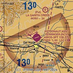
| Sectional chart |
|---|
|
| Airport distance calculator |
|---|
|
|
| Sunrise and sunset |
|---|
|
Times for 17-Jul-2026
| | Local
(UTC-6) | | Zulu
(UTC) |
|---|
| Morning civil twilight | | 05:28 | | 11:28 |
| Sunrise | | 05:58 | | 11:58 |
| Sunset | | 20:25 | | 02:25 |
| Evening civil twilight | | 20:55 | | 02:55 |
|
| Current date and time |
|---|
| Zulu (UTC) | 18-Jul-2026 02:04:06 |
|---|
| Local (UTC-6) | 17-Jul-2026 20:04:06 |
|---|
|
| METAR |
|---|
| KRCV | 180135Z AUTO 17005KT 10SM BKN080 OVC110 20/09 A3037 RMK AO2 LTG DSNT W T02040086
|
|
| TAF |
|---|
KALS
29nm SE | 171724Z 1718/1818 VRB03KT P6SM SKC FM172000 16009KT P6SM VCTS SCT090CB BKN150 TEMPO 1721/1801 VRB25G40KT -TSRA BKN060CB FM180100 29008KT P6SM VCSH SCT060 FM180300 VRB03KT P6SM SKC
|
|
| NOTAMs |
|---|
NOTAMs are issued by the DoD/FAA and will open in a separate window not controlled by AirNav.
|
|

