FAA INFORMATION EFFECTIVE 11 JUNE 2026
Location
| FAA Identifier: | RDM |
| Lat/Long: | 44-15-14.6480N 121-08-59.8970W
44-15.244133N 121-08.998283W
44.2540689,-121.1499714
(estimated) |
| Elevation: | 3081.5 ft. / 939.2 m (surveyed) |
| Variation: | 14E (2020) |
| From city: | 1 mile SE of REDMOND, OR |
| Time zone: | UTC -7 (UTC -8 during Standard Time) |
| Zip code: | 97756 |
Airport Operations
| Airport use: | Open to the public |
| Activation date: | 09/1938 |
| Control tower: | yes |
| ARTCC: | SEATTLE CENTER |
| FSS: | MC MINNVILLE FLIGHT SERVICE STATION |
| NOTAMs facility: | RDM (NOTAM-D service available) |
| Attendance: | 0400-2000
FOR FUEL AFT HRS CALL FBO 541-504-3848. UNICOM: FBO 122.85. |
| Wind indicator: | yes |
| Segmented circle: | no |
| Lights: | WHEN ATCT CLSD ACTVT HIRL RY 05/23, MIRL RY 11/29, MALSR RY 23, REIL RY 05, 11 & 29, AND TWY LGTS - CTAF. |
| Beacon: | white-green (lighted land airport)
Operates sunset to sunrise. |
| Fire and rescue: | ARFF index B |
Airport Communications
| CTAF: | 124.5 |
| UNICOM: | 122.95 |
| ATIS: | 119.025 |
| WX ASOS: | 119.025 (541-504-8743) |
| REDMOND GROUND: | 121.8 [0600-2200] |
| REDMOND TOWER: | 124.5 256.8 [0600-2200] |
| WX AWOS-3 at BDN (10 nm S): | 134.425 (541-382-1477) |
| WX AWOS-3PT at S39 (11 nm E): | 118.325 (541-447-4060) |
- APCH/DEP CTL SVC PRVDD BY SEATTLE ARTCC (ZSE) ON FREQS126.15/269.475 (REDMOND RCAG).
- ATC RADAR SVC PRVDD WITHIN 40 NM RADIUS BY SEATTLE ARTCC TO TRANSPONDER EQUIPPED ACFT ONLY. RDM ATCT DOES NOT PROVIDE ATC RADAR SVC.
Nearby radio navigation aids
| VOR radial/distance | | VOR name | | Freq | | Var |
|---|
| DSDr071/6.6 | | DESCHUTES VORTAC | | 117.60 | | 18E |
Airport Services
| Fuel available: | 100LL JET-A MOGAS |
| Parking: | hangars and tiedowns |
| Airframe service: | MAJOR |
| Powerplant service: | MAJOR |
| Bottled oxygen: | HIGH/LOW |
| Bulk oxygen: | HIGH/LOW |
Runway Information
Runway 5/23
| Dimensions: | 7038 x 150 ft. / 2145 x 46 m |
| Surface: | asphalt/grooved, in good condition |
| Weight bearing capacity: | | Single wheel: | 120.0 | | Double wheel: | 216.0 | | Double tandem: | 399.0 |
|
| Runway edge lights: | high intensity |
| RUNWAY 5 | | RUNWAY 23 |
| Latitude: | 44-14.970562N | | 44-15.543253N |
| Longitude: | 121-09.707077W | | 121-08.306535W |
| Elevation: | 3074.1 ft. | | 3053.9 ft. |
| Traffic pattern: | left | | left |
| Runway heading: | 046 magnetic, 060 true | | 226 magnetic, 240 true |
| Declared distances: | TORA:7038 TODA:7038 ASDA:7038 LDA:7038 | | TORA:7038 TODA:7038 ASDA:7031 LDA:7031 |
| Markings: | precision, in good condition | | precision, in good condition |
| Visual slope indicator: | 4-box VASI on left (3.00 degrees glide path) | | 4-light PAPI on left (3.00 degrees glide path) |
| Approach lights: | | | MALSR: 1,400 foot medium intensity approach lighting system with runway alignment indicator lights |
| Runway end identifier lights: | yes | | |
| Touchdown point: | yes, no lights | | yes, no lights |
| Instrument approach: | | | ILS/DME |
Runway 11/29
| Dimensions: | 7006 x 100 ft. / 2135 x 30 m |
| Surface: | asphalt/grooved, in good condition |
| Weight bearing capacity: | | Single wheel: | 109.0 | | Double wheel: | 178.0 |
|
| Runway edge lights: | medium intensity |
| RUNWAY 11 | | RUNWAY 29 |
| Latitude: | 44-15.535858N | | 44-14.926607N |
| Longitude: | 121-09.670677W | | 121-08.308777W |
| Elevation: | 3047.2 ft. | | 3081.4 ft. |
| Traffic pattern: | left | | left |
| Runway heading: | 108 magnetic, 122 true | | 288 magnetic, 302 true |
| Declared distances: | TORA:7006 TODA:7006 ASDA:7006 LDA:7006 | | TORA:7006 TODA:7006 ASDA:7006 LDA:7006 |
| Markings: | nonprecision, in good condition | | nonprecision, in good condition |
| Visual slope indicator: | 4-light PAPI on left (3.00 degrees glide path) | | 4-light PAPI on left (3.00 degrees glide path)
UNUSBL BYD 5.0 NM FM THD, DOES NOT PRVD OBSTN CLNC. |
| Runway end identifier lights: | yes | | yes |
| Touchdown point: | yes, no lights | | yes, no lights |
Helipad H1
| Dimensions: | 48 x 48 ft. / 15 x 15 m |
| Surface: | concrete |
| Operational restrictions: | PVT USE HELIPAD, CTC TWR. WHEN TWR CLSD USE CTAF. |
| Latitude: | 44-15.621500N | | |
| Longitude: | 121-08.448667W | | |
| Elevation: | 3056.0 ft. | | |
| Traffic pattern: | left | | left |
Airport Ownership and Management from official FAA records
| Ownership: | Publicly-owned |
| Owner: | CITY OF REDMOND
411 SW 9TH STREET
REDMOND, OR 97756-0100
Phone (541) 504-3085 |
| Manager: | ZACHARY BASS
2522 SE JESSE BUTLER CIRCLE #17
REDMOND, OR 97756-8643
Phone (541) 504-3085 |
Additional Remarks
| A39-05/23 | PCR VALUE: 530/F/A/X/T |
| A39-11/29 | PCR VALUE: 530/F/A/X/T |
| - | TRANSIENT HELICOPTER OPS PREFERRED NORTH (CONCRETE) GENERAL AVIATION RAMP. |
| - | FOR CD IF UNA TO CTC ON FSS FREQ, CTC SEATTLE ARTCC AT 253-351-3694. |
| - | COLD TEMPERATURE AIRPORT. ALTITUDE CORRECTION REQUIRED AT OR BELOW -16C. |
| - | PILOTS CONDUCTING EFVS OPS; BE AWARE LED ALS IN USE RWY 23. |
| - | OCNL WILDLIFE ON AND INVOF ARPT. |
| - | TERMINAL APRON NOT AVBL FOR GENERAL AVIATION ACFT. |
Instrument Procedures
NOTE: All procedures below are presented as PDF files. If you need a reader for these files, you should download the free Adobe Reader.NOT FOR NAVIGATION. Please procure official charts for flight.
FAA instrument procedures published for use from 11 June 2026 at 0901Z to 09 July 2026 at 0900z.
IAPs - Instrument Approach Procedures |
|---|
| ILS OR LOC RWY 23 | |
download (674KB) |
| RNAV (RNP) Z RWY 05 | |
download (304KB) |
| RNAV (RNP) Z RWY 23 | |
download (274KB) |
| RNAV (GPS) RWY 11 | |
download (319KB) |
| RNAV (GPS) Y RWY 05 | |
download (335KB) |
| RNAV (GPS) Y RWY 23 | |
download (364KB) |
| RNAV (GPS) Y RWY 29 | |
download (292KB) |
| RNAV (GPS) Z RWY 29 | |
download (280KB) |
| VOR-A | |
download (244KB) |
| JUNIPER VISUAL RWY 23 | |
download (156KB) |
| NOTE: Special Alternate Minimums apply | |
download (211KB) |
Departure Procedures |
|---|
| REDMOND THREE | |
download (244KB) |
| NOTE: Special Take-Off Minimums/Departure Procedures apply | |
download (530KB) |
Other nearby airports with instrument procedures:
KBDN - Bend Municipal Airport (10 nm S)
S39 - Prineville Airport (11 nm E)
S33 - Madras Municipal Airport (25 nm N)
S21 - Sunriver Airport (26 nm SW)
62S - Christmas Valley Airport (65 nm S)
|
|

Road maps at:
MapQuest
Bing
Google
| Aerial photo |
|---|
WARNING: Photo may not be current or correct
 Taken in February 2008
Do you have a better or more recent aerial photo of Roberts Field Redmond Municipal Airport that you would like to share? If so, please send us your photo.
|
| Sectional chart |
|---|
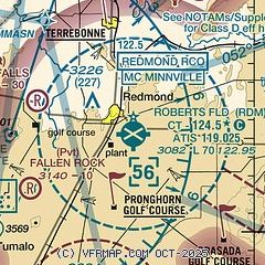
|
 Download PDF
of official airport diagram from the FAA
| Airport distance calculator |
|---|
|
|
| Sunrise and sunset |
|---|
|
Times for 19-Jun-2026
| | Local
(UTC-7) | | Zulu
(UTC) |
|---|
| Morning civil twilight | | 04:45 | | 11:45 |
| Sunrise | | 05:21 | | 12:21 |
| Sunset | | 20:50 | | 03:50 |
| Evening civil twilight | | 21:27 | | 04:27 |
|
| Current date and time |
|---|
| Zulu (UTC) | 19-Jun-2026 16:48:59 |
|---|
| Local (UTC-7) | 19-Jun-2026 09:48:59 |
|---|
|
| METAR |
|---|
| KRDM | 191556Z 00000KT 10SM CLR 22/01 A2995 RMK AO2 SLP113 T02170006 $
|
KBDN
10nm S | 191635Z AUTO 32005KT 10SM CLR 25/M00 A2994 RMK AO2
|
KS39
11nm E | 191635Z AUTO 00000KT 10SM CLR 23/M01 A2994 RMK AO2
|
|
| TAF |
|---|
| KRDM | 191120Z 1912/2012 VRB05KT P6SM FEW250 FM191900 33008KT P6SM SCT250 FM192200 32015G25KT P6SM BKN150 BKN250 FM200400 30009KT P6SM FEW100 BKN150 BKN250
|
KBDN
10nm S | 191120Z 1912/2012 VRB03KT P6SM FEW250 FM191900 33008KT P6SM SCT250 FM192300 32012G20KT P6SM BKN150 BKN250 FM200300 35009KT P6SM FEW100 BKN150 BKN250
|
|
| NOTAMs |
|---|
NOTAMs are issued by the DoD/FAA and will open in a separate window not controlled by AirNav.
|
|


