FAA INFORMATION EFFECTIVE 14 MAY 2026
Location
| FAA Identifier: | ROA |
| Lat/Long: | 37-19-31.7000N 079-58-31.5000W
37-19.528333N 079-58.525000W
37.3254722,-79.9754167
(estimated) |
| Elevation: | 1175.2 ft. / 358.2 m (surveyed) |
| Variation: | 08W (2010) |
| From city: | 3 miles NW of ROANOKE, VA |
| Time zone: | UTC -4 (UTC -5 during Standard Time) |
| Zip code: | 24019 |
Airport Operations
| Airport use: | Open to the public |
| Activation date: | 05/1930 |
| Control tower: | yes |
| ARTCC: | WASHINGTON CENTER |
| FSS: | LEESBURG FLIGHT SERVICE STATION |
| NOTAMs facility: | ROA (NOTAM-D service available) |
| Attendance: | CONTINUOUS |
| Pattern altitude: | 1975.2 ft. MSL |
| Wind indicator: | lighted |
| Segmented circle: | yes |
| Lights: | SS-SR |
| Beacon: | white-green (lighted land airport)
Operates sunset to sunrise. |
| Fire and rescue: | ARFF index B |
Airport Communications
| UNICOM: | 122.95 |
| ATIS: | 132.375 |
| WX ASOS: | PHONE 540-216-0158 |
| ROANOKE GROUND: | 121.9 257.8 |
| ROANOKE TOWER: | 118.3 257.8 |
| ROANOKE APPROACH: | 118.15 ;RWY 16/34 360-150, RWY 06 23 133.225 ;RWY 16/34 151-359, RWY 06 0 339.8 ;RWY 06, 16/34 |
| ROANOKE DEPARTURE: | 118.15 ;RWY 16/34 360-150, RWY 06 23 133.225 ;RWY 16/34 151-359, RWY 06 0 339.8 ;RWY 06, 16/34 |
| CLEARANCE DELIVERY: | 119.7 |
| CLASS C: | 118.15 ;RWY 16/34 360-150, RWY 06 23 133.225 ;RWY 16/34 151-359, RWY 06 0 339.8 ;RWY 06, 16/34 |
| EMERG: | 121.5 243.0 |
| IC: | 133.225 ;RWY 16/34 151-359, RWY 06 0 339.8 ;RWY 06, 16/34 |
Nearby radio navigation aids
| VOR radial/distance | | VOR name | | Freq | | Var |
|---|
| LYHr282/35.5 | | LYNCHBURG VOR/DME | | 109.20 | | 05W |
| PSKr074/38.0 | | PULASKI VORTAC | | 116.80 | | 06W |
| NDB name | | Hdg/Dist | | Freq | | Var | | ID |
|---|
| VINTON | | 336/8.6 | | 277 | | 08W | | VIT | ...- .. - |
| TECH | | 079/21.6 | | 368 | | 08W | | TEC | - . -.-. |
Airport Services
| Fuel available: | 100LL JET-A |
| Parking: | hangars and tiedowns |
| Airframe service: | MAJOR |
| Powerplant service: | MAJOR |
| Bottled oxygen: | NONE |
| Bulk oxygen: | HIGH/LOW |
Runway Information
Runway 6/24
| Dimensions: | 6800 x 150 ft. / 2073 x 46 m |
| Surface: | asphalt/grooved, in good condition |
| Weight bearing capacity: | | Single wheel: | 150.0 | | Double wheel: | 200.0 | | Double tandem: | 310.0 |
|
| Runway edge lights: | high intensity |
| RUNWAY 6 | | RUNWAY 24 |
| Latitude: | 37-19.334133N | | 37-20.058447N |
| Longitude: | 079-59.039960W | | 079-57.969517W |
| Elevation: | 1152.0 ft. | | 1150.7 ft. |
| Traffic pattern: | left | | left |
| Runway heading: | 058 magnetic, 050 true | | 238 magnetic, 230 true |
| Displaced threshold: | no | | 790 ft. |
| Declared distances: | TORA:6800 TODA:6800 ASDA:6800 LDA:6800 | | TORA:6800 TODA:6800 ASDA:6800 LDA:6010 |
| Markings: | precision, in good condition | | nonprecision, in good condition |
| Visual slope indicator: | 4-box VASI on left (3.00 degrees glide path) | | 4-light PAPI on left (3.00 degrees glide path)
PAPI UNUSBL BYD 5 DEGS R OF CNTRLN DUE TO TRRN. |
| Approach lights: | MALSR: 1,400 foot medium intensity approach lighting system with runway alignment indicator lights | | |
| Runway end identifier lights: | yes | | yes |
| Touchdown point: | yes, no lights | | yes, no lights |
| Instrument approach: | LDA/DME | | |
Runway 16/34
| Dimensions: | 5810 x 150 ft. / 1771 x 46 m |
| Surface: | asphalt/grooved, in good condition |
| Weight bearing capacity: | | Single wheel: | 150.0 | | Double wheel: | 200.0 | | Double tandem: | 310.0 |
|
| Runway edge lights: | high intensity |
| RUNWAY 16 | | RUNWAY 34 |
| Latitude: | 37-19.737388N | | 37-18.926242N |
| Longitude: | 079-58.867565W | | 079-58.230953W |
| Elevation: | 1165.6 ft. | | 1142.9 ft. |
| Traffic pattern: | left | | left |
| Runway heading: | 156 magnetic, 148 true | | 336 magnetic, 328 true |
| Declared distances: | TORA:5810 TODA:5810 ASDA:5810 LDA:5810 | | TORA:5810 TODA:5810 ASDA:5810 LDA:5810 |
| Markings: | nonprecision, in good condition | | precision, in good condition |
| Visual slope indicator: | | | 4-light PAPI on left (3.00 degrees glide path) |
| Approach lights: | | | MALSR: 1,400 foot medium intensity approach lighting system with runway alignment indicator lights |
| Touchdown point: | yes, no lights | | yes, no lights |
| Instrument approach: | | | ILS |
| Obstructions: | none | | 837 ft. tower, lighted, 26070 ft. from runway, 30:1 slope to clear |
Airport Ownership and Management from official FAA records
| Ownership: | Publicly-owned |
| Owner: | ROANOKE BLACKSBURG RGNL/WOODRUM FIE
5202 AVN DR.
ROANOKE, VA 24012-1148
Phone 540 362-1999 |
| Manager: | MIKE STEWART
5202 AVN DR.
ROANOKE, VA 24012-1148
Phone 540-362-1999 |
Additional Remarks
| A39-06/24 | PCR VALUE: 530/F/B/X/T |
| A39-16/34 | PCR VALUE: 484/F/A/X/T |
| E60-34 | ENGINEERED MATERIALS ARRESTING SYSTEM (EMAS) 433 FT IN LENGTH BY 178 FT IN WIDTH LCTD AT DER 34. |
| - | DEP RWY 34 & ARR RWY 16 NA AT NIGHT OR DURING IFR COND DUE TO TRRN. |
| - | TSNT PILOTS CTC FBO UNICOM FOR ACFT PARKING AND ESCORT. |
| - | BIRDS INVOF ARPT. |
| - | TWY T CLSD TO ACFT WITH WINGSPAN GREATER THAN 118 FT. |
| - | COLD TEMPERATURE AIRPORT. ALTITUDE CORRECTION REQUIRED AT OR BELOW -12C. |
| - | FOR OPR CONCERNS - ATCT 540-563-1307. |
| - | TKOF AND LNDG PER & RWY COND ASSESSMENT MATRIX NOT MNTD 0000 - 0530 HRS DLY. |
Instrument Procedures
NOTE: All procedures below are presented as PDF files. If you need a reader for these files, you should download the free Adobe Reader.NOT FOR NAVIGATION. Please procure official charts for flight.
FAA instrument procedures published for use from 14 May 2026 at 0901Z to 11 June 2026 at 0900Z.
IAPs - Instrument Approach Procedures |
|---|
| ILS OR LOC RWY 34 | |
download (279KB) |
| RNAV (RNP) Z RWY 06 | |
download (220KB) |
| RNAV (RNP) Z RWY 24 | |
download (210KB) |
| RNAV (RNP) Z RWY 34 | |
download (279KB) |
| RNAV (GPS) Y RWY 06 | |
download (232KB) |
| RNAV (GPS) Y RWY 24 | |
download (242KB) |
| RNAV (GPS) Y RWY 34 | |
download (302KB) |
| LDA Y RWY 06 | |
download (283KB) |
| LDA Z RWY 06 | |
download (232KB) |
| NOTE: Special Alternate Minimums apply | |
download (168KB) |
Departure Procedures |
|---|
| BUFIY FOUR (RNAV) | |
download (143KB) |
| DIXXY EIGHT | |
download (129KB) |
| MONAT FOUR (RNAV) | |
download (137KB) |
| SCUTA THREE (RNAV) | |
download (157KB) |
| NOTE: Special Take-Off Minimums/Departure Procedures apply | |
download (357KB) |
Other nearby airports with instrument procedures:
KBCB - Virginia Tech/Montgomery Executive Airport (22 nm W)
W91 - Smith Mountain Lake Airport (22 nm SE)
W90 - New London Airport (31 nm E)
KPSK - New River Valley Airport (35 nm W)
KLYH - Lynchburg Regional Airport/Preston Glenn Field (37 nm E)
|
|

Road maps at:
MapQuest
Bing
Google
| Aerial photo |
|---|
WARNING: Photo may not be current or correct
 Photo by Ken Stringer
Photo taken 21-Jun-2015
looking east.
Photo by Ken Stringer
Photo taken 21-Jun-2015
looking east.
Do you have a better or more recent aerial photo of Roanoke-Blacksburg Regional Airport/Woodrum Field that you would like to share? If so, please send us your photo.
|
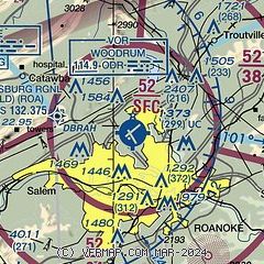
| Sectional chart |
|---|
|
 Download PDF
of official airport diagram from the FAA
| Airport distance calculator |
|---|
|
|
| Sunrise and sunset |
|---|
|
Times for 27-May-2026
| | Local
(UTC-4) | | Zulu
(UTC) |
|---|
| Morning civil twilight | | 05:34 | | 09:34 |
| Sunrise | | 06:04 | | 10:04 |
| Sunset | | 20:30 | | 00:30 |
| Evening civil twilight | | 21:00 | | 01:00 |
|
| Current date and time |
|---|
| Zulu (UTC) | 27-May-2026 17:41:22 |
|---|
| Local (UTC-4) | 27-May-2026 13:41:22 |
|---|
|
| METAR |
|---|
| KROA | 271654Z 25003KT 10SM FEW041 BKN050 BKN140 27/18 A3003 RMK AO2 SLP158 T02720183
|
|
| TAF |
|---|
| KROA | 271120Z 2712/2812 VRB03KT P6SM OVC120 FM271500 26005KT P6SM VCSH BKN080 FM271900 24010KT P6SM -TSRA SCT050CB FM280100 28005KT P6SM SCT110
|
|
| NOTAMs |
|---|
NOTAMs are issued by the DoD/FAA and will open in a separate window not controlled by AirNav.
|
|


