FAA INFORMATION EFFECTIVE 14 MAY 2026
Location
| FAA Identifier: | SJN |
| Lat/Long: | 34-31-06.8000N 109-22-43.5000W
34-31.113333N 109-22.725000W
34.5185556,-109.3787500
(estimated) |
| Elevation: | 5736.5 ft. / 1748.5 m (surveyed) |
| Variation: | 12E (1980) |
| From city: | 1 mile N of ST JOHNS, AZ |
| Time zone: | UTC -7 (year round; does not observe DST) |
| Zip code: | 85936 |
Airport Operations
| Airport use: | Open to the public |
| Activation date: | 04/1940 |
| Control tower: | no |
| ARTCC: | ALBUQUERQUE CENTER |
| FSS: | PRESCOTT FLIGHT SERVICE STATION |
| NOTAMs facility: | SJN (NOTAM-D service available) |
| Attendance: | 0700-1700 |
| Wind indicator: | lighted |
| Segmented circle: | yes |
| Lights: | ACTVT REIL RWY 14 & 32; PAPI RWY 14 & 32; MIRL RWY 03/21 & 14/32 - CTAF. |
| Beacon: | white-green (lighted land airport)
Operates sunset to sunrise. |
Airport Communications
| CTAF/UNICOM: | 122.8 |
| WX ASOS: | 134.225 (928-337-3061) |
- APCH/DEP SVC PRVDD BY ALBUQUERQUE ARTCC (ZAB) ON FREQS 124.325/288.25 (ZUNI RCAG).
Nearby radio navigation aids
| VOR radial/distance | | VOR name | | Freq | | Var |
|---|
| SJNr284/12.9 | | ST JOHNS VORTAC | | 112.30 | | 12E |
| ZUNr188/29.0 | | ZUNI VORTAC | | 113.40 | | 14E |
Airport Services
| Fuel available: | 100LL JET-A+ |
| Parking: | hangars and tiedowns |
Runway Information
Runway 14/32
| Dimensions: | 5322 x 75 ft. / 1622 x 23 m |
| Surface: | asphalt, in good condition |
| Weight bearing capacity: | |
| Runway edge lights: | medium intensity |
| Operational restrictions: | RWY 32 CALM WIND RWY. |
| RUNWAY 14 | | RUNWAY 32 |
| Latitude: | 34-31.570465N | | 34-30.823985N |
| Longitude: | 109-22.963275W | | 109-22.407102W |
| Elevation: | 5734.1 ft. | | 5736.5 ft. |
| Traffic pattern: | left | | left |
| Runway heading: | 136 magnetic, 148 true | | 316 magnetic, 328 true |
| Displaced threshold: | no | | 92 ft. |
| Markings: | nonprecision, in poor condition | | nonprecision, in poor condition |
| Visual slope indicator: | 2-light PAPI on left (3.00 degrees glide path) | | 2-light PAPI on right (3.00 degrees glide path) |
| Runway end identifier lights: | yes | | yes |
| Touchdown point: | yes, no lights | | yes, no lights |
| Obstructions: | none | | 17 ft. pole, lighted, 375 ft. from runway, 135 ft. right of centerline, 10:1 slope to clear
0-12 FT FENCE 0-200 FT FM THR 135-150 FT R OF CNTRLN. +10 FT ROAD 0-150 FT FM RWY END ACRS THR. |
Runway 3/21
| Dimensions: | 3400 x 60 ft. / 1036 x 18 m |
| Surface: | asphalt, in good condition |
| Weight bearing capacity: | |
| Runway edge lights: | medium intensity |
| Runway edge markings: | FADED & MISG. |
| RUNWAY 3 | | RUNWAY 21 |
| Latitude: | 34-30.759858N | | 34-31.207567N |
| Longitude: | 109-22.991542W | | 109-22.584427W |
| Elevation: | 5727.0 ft. | | 5734.7 ft. |
| Traffic pattern: | left | | left |
| Runway heading: | 025 magnetic, 037 true | | 205 magnetic, 217 true |
| Displaced threshold: | 190 ft. | | no |
| Markings: | basic, in poor condition | | basic, in poor condition |
| Runway end identifier lights: | no | | no |
| Touchdown point: | yes, no lights | | yes, no lights |
| Obstructions: | 58 ft. tree, 440 ft. from runway, 50 ft. left of centerline, 4:1 slope to clear
APCH RATIO 10:1 TO DTHR; 58 FT TREE 630 FT FM RWY END 50 FT L OF CNTRLN. | | none
5 FT DIRT PILE 100 FT FM THR 85 FT R OF CNTRLN. |
Airport Ownership and Management from official FAA records
| Ownership: | Publicly-owned |
| Owner: | CITY OF ST. JOHNS
P.O. BOX 455
ST. JOHNS, AZ 85936
Phone 928-337-4517 |
| Manager: | GARY LISTON
P.O. BOX 455
ST. JOHNS, AZ 85936
Phone 928-337-4254
EMERG - 928-245-0391 |
Additional Remarks
| A30A-03 | 200 FT GRAVEL CLEAR AREA. |
| - | MIL TFC INVOF ARPT. |
| - | RWY 14/32 PARL TWY REFLECTORS FULL LEN BOTH SIDES. |
| - | FOR CD IF UNA TO CTC ON FSS FREQ, CTC ALBUQUERQUE ARTCC AT 505-856-4561. |
Instrument Procedures
NOTE: All procedures below are presented as PDF files. If you need a reader for these files, you should download the free Adobe Reader.NOT FOR NAVIGATION. Please procure official charts for flight.
FAA instrument procedures published for use from 14 May 2026 at 0901Z to 11 June 2026 at 0900Z.
IAPs - Instrument Approach Procedures |
|---|
| RNAV (GPS) RWY 14 | |
download (225KB) |
| RNAV (GPS) RWY 32 | |
download (246KB) |
| NOTE: Special Alternate Minimums apply **CHANGED** | |
download (143KB) |
| NOTE: Special Take-Off Minimums/Departure Procedures apply | |
download (378KB) |
Other nearby airports with instrument procedures:
KJTC - Springerville Municipal Airport (24 nm S)
KSOW - Show Low Regional Airport (35 nm SW)
KTYL - Taylor Airport (37 nm W)
KGUP - Gallup Municipal Airport (66 nm NE)
KRQE - Window Rock Airport (70 nm N)
|
|

Road maps at:
MapQuest
Bing
Google
| Aerial photo |
|---|
WARNING: Photo may not be current or correct

Do you have a better or more recent aerial photo of St Johns Industrial Air Park that you would like to share? If so, please send us your photo.
|
| Sectional chart |
|---|
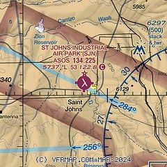
|
| Airport distance calculator |
|---|
|
|
| Sunrise and sunset |
|---|
|
Times for 30-May-2026
| | Local
(UTC-7) | | Zulu
(UTC) |
|---|
| Morning civil twilight | | 04:39 | | 11:39 |
| Sunrise | | 05:08 | | 12:08 |
| Sunset | | 19:22 | | 02:22 |
| Evening civil twilight | | 19:51 | | 02:51 |
|
| Current date and time |
|---|
| Zulu (UTC) | 31-May-2026 03:54:57 |
|---|
| Local (UTC-7) | 30-May-2026 20:54:57 |
|---|
|
| METAR |
|---|
| KSJN | 310254Z AUTO 33004KT 10SM CLR 20/M06 A3004 RMK AO2 SLP097 T02001056 53012
|
|
| NOTAMs |
|---|
NOTAMs are issued by the DoD/FAA and will open in a separate window not controlled by AirNav.
|
|

