FAA INFORMATION EFFECTIVE 14 MAY 2026
Location
| FAA Identifier: | SOW |
| Lat/Long: | 34-15-55.6980N 110-00-20.3850W
34-15.928300N 110-00.339750W
34.2654717,-110.0056625
(estimated) |
| Elevation: | 6415.5 ft. / 1955.4 m (surveyed) |
| Variation: | 10E (2020) |
| From city: | 2 miles E of SHOW LOW, AZ |
| Time zone: | UTC -7 (year round; does not observe DST) |
| Zip code: | 85901 |
Airport Operations
| Airport use: | Open to the public |
| Activation date: | 12/1946 |
| Control tower: | no |
| ARTCC: | ALBUQUERQUE CENTER |
| FSS: | PRESCOTT FLIGHT SERVICE STATION |
| NOTAMs facility: | SOW (NOTAM-D service available) |
| Attendance: | JAN-DEC 0700-1900 |
| Pattern altitude: | 7215.5 ft. MSL |
| Wind indicator: | lighted |
| Segmented circle: | yes |
| Lights: | ACTVT REIL RWY 07 & 25; PAPI RWY 07 & 25; MIRL RWY 07/25 - CTAF. |
| Beacon: | white-green (lighted land airport)
Operates sunset to sunrise. |
| Fire and rescue: | ARFF index A |
Airport Communications
| CTAF/UNICOM: | 123.0 |
| WX AWOS-3: | 118.075 (928-532-0379) |
| WX AWOS-3PT at TYL (12 nm NW): | 119.075 (928-387-2084) |
- APCH/DEP SVC PRVDD BY ALBUQUERQUE ARTCC(ZAB) ON FREQS 132.9/239.05 (GLOBE NR 1 RCAG).
Airport Services
| Fuel available: | 100LL JET-A
100LL:SELF SVC FUEL H24. |
| Parking: | tiedowns |
| Airframe service: | MINOR |
| Powerplant service: | MINOR |
Runway Information
Runway 7/25
| Dimensions: | 7202 x 100 ft. / 2195 x 30 m |
| Surface: | asphalt, in excellent condition |
| Weight bearing capacity: | | Single wheel: | 35.0 | | Double wheel: | 60.0 |
|
| Runway edge lights: | medium intensity |
| RUNWAY 7 | | RUNWAY 25 |
| Latitude: | 34-15.826475N | | 34-16.114077N |
| Longitude: | 110-01.132033W | | 109-59.745025W |
| Elevation: | 6399.2 ft. | | 6399.8 ft. |
| Traffic pattern: | left | | right |
| Runway heading: | 066 magnetic, 076 true | | 246 magnetic, 256 true |
| Displaced threshold: | 700 ft. | | no |
| Declared distances: | TORA:7200 TODA:7200 ASDA:7200 LDA:6500 | | TORA:7200 TODA:7200 ASDA:7200 LDA:7200 |
| Markings: | nonprecision, in good condition | | nonprecision, in good condition |
| Visual slope indicator: | 2-light PAPI on left (3.00 degrees glide path) | | 2-light PAPI on left (3.00 degrees glide path) |
| Runway end identifier lights: | yes | | yes |
| Touchdown point: | yes, no lights | | yes, no lights |
Runway 4/22
| Dimensions: | 3938 x 60 ft. / 1200 x 18 m |
| Surface: | asphalt, in good condition |
| Weight bearing capacity: | |
| Operational restrictions: | RWY 04/22 NOT AVBL FOR PART 121/PART 380 OPS WITH SKED PAX CARRYING OPS MORE THAN 9 PAX SEATS AND NON-SKED PAX CARRYING OPS MORE THAN 30 PAX SEATS. |
| RUNWAY 4 | | RUNWAY 22 |
| Latitude: | 34-15.633392N | | 34-16.069517N |
| Longitude: | 110-00.448638W | | 109-59.869568W |
| Elevation: | 6412.9 ft. | | 6400.6 ft. |
| Traffic pattern: | right | | left |
| Runway heading: | 038 magnetic, 048 true | | 218 magnetic, 228 true |
| Declared distances: | TORA:3938 TODA:3938 ASDA:3938 LDA:3938 | | TORA:3938 TODA:3938 ASDA:3938 LDA:3938 |
| Markings: | basic, in good condition | | basic, in good condition |
| Runway end identifier lights: | no | | no |
| Touchdown point: | yes, no lights | | yes, no lights |
Airport Ownership and Management from official FAA records
| Ownership: | Publicly-owned |
| Owner: | CITY OF SHOWLOW
180 N. 9TH PLACE
SHOW LOW, AZ 85901
Phone (928) 532-4000 |
| Manager: | JACOB ALLEN
3150 AIRPORT LOOP, #100
SHOW LOW, AZ 85901
Phone 928-532-4190 |
Additional Remarks
| A39-04/22 | PCR VALUE: 65/F/D/Y/T |
| A39-07/25 | PCR VALUE: 269/F/D/X/T |
| A30A-07 | APCH RATIO 40:1 TO DTHR. |
| - | PART 77 OBSTNS & WIND SOCK IN 7-1 TRSN. |
| - | MIL TFC INVOF ARPT. |
| - | OVNGT TSNT & COML OPS LNDG FEE. |
| - | RWY 04/22 & 07/25 NOT CONNECTED BY PAVEMENT AT APCH END RWY 22. |
| - | RWY 22 & 25 SIMUL OPS NA. |
| - | FOR CD CTC ALBUQUERQUE ARTCC AT 505-856-4861. |
Instrument Procedures
NOTE: All procedures below are presented as PDF files. If you need a reader for these files, you should download the free Adobe Reader.NOT FOR NAVIGATION. Please procure official charts for flight.
FAA instrument procedures published for use from 14 May 2026 at 0901Z to 11 June 2026 at 0900Z.
IAPs - Instrument Approach Procedures |
|---|
| RNAV (GPS) RWY 25 **CHANGED** | |
download (236KB) |
| NOTE: Special Alternate Minimums apply | |
download (52KB) |
| NOTE: Special Take-Off Minimums/Departure Procedures apply | |
download (357KB) |
Other nearby airports with instrument procedures:
KTYL - Taylor Airport (12 nm NW)
KSJN - St Johns Industrial Air Park (35 nm NE)
KJTC - Springerville Municipal Airport (35 nm E)
KINW - Winslow-Lindbergh Regional Airport (58 nm NW)
P13 - San Carlos Apache Airport (64 nm SW)
|
|

Road maps at:
MapQuest
Bing
Google
| Aerial photo |
|---|
WARNING: Photo may not be current or correct
 Photo by Dylan Bearce
Photo taken 15-Aug-2009
Photo by Dylan Bearce
Photo taken 15-Aug-2009
Do you have a better or more recent aerial photo of Show Low Regional Airport that you would like to share? If so, please send us your photo.
|
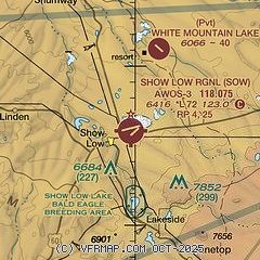
| Sectional chart |
|---|
|
| Airport distance calculator |
|---|
|
|
| Sunrise and sunset |
|---|
|
Times for 28-May-2026
| | Local
(UTC-7) | | Zulu
(UTC) |
|---|
| Morning civil twilight | | 04:43 | | 11:43 |
| Sunrise | | 05:11 | | 12:11 |
| Sunset | | 19:23 | | 02:23 |
| Evening civil twilight | | 19:52 | | 02:52 |
|
| Current date and time |
|---|
| Zulu (UTC) | 28-May-2026 08:41:45 |
|---|
| Local (UTC-7) | 28-May-2026 01:41:45 |
|---|
|
| METAR |
|---|
| KSOW | 280815Z AUTO 20013KT 10SM CLR 13/M02 A3005 RMK AO2
|
KTYL
12nm NW | 280815Z AUTO 16004KT 10SM CLR 12/M05 A3003 RMK AO2
|
|
| NOTAMs |
|---|
NOTAMs are issued by the DoD/FAA and will open in a separate window not controlled by AirNav.
|
|


