FAA INFORMATION EFFECTIVE 25 DECEMBER 2025
Location
| FAA Identifier: | SRE |
| Lat/Long: | 35-16-28.0538N 096-40-31.3641W
35-16.467563N 096-40.522735W
35.2744594,-96.6753789
(estimated) |
| Elevation: | 1023.1 ft. / 311.8 m (surveyed) |
| Variation: | 06E (1985) |
| From city: | 3 miles N of SEMINOLE, OK |
| Time zone: | UTC -6 (UTC -5 during Daylight Saving Time) |
| Zip code: | 74868 |
Airport Operations
| Airport use: | Open to the public |
| Activation date: | 10/1942 |
| Control tower: | no |
| ARTCC: | FORT WORTH CENTER |
| FSS: | MC ALESTER FLIGHT SERVICE STATION |
| NOTAMs facility: | SRE (NOTAM-D service available) |
| Attendance: | MON-FRI 0800-1700, ALL SAT 0800-1200 |
| Wind indicator: | lighted |
| Segmented circle: | yes |
| Lights: | MIRL RWY 16/34 PRESET LOW INTST, INCR INTST - CTAF. |
| Beacon: | white-green (lighted land airport)
Operates sunset to sunrise. |
Airport Communications
| CTAF/UNICOM: | 122.8 |
| WX AWOS-3: | 118.625 (405-382-0111) |
| WX AWOS-3PT at SNL (14 nm W): | 118.275 (405-214-1916) |
- APCH/DEP CTL SVC PRVDD BY FORT WORTH ARTCC (ZFW) ON FREQS 132.2/338.35 (MC ALESTER RCAG).
Nearby radio navigation aids
| NDB name | | Hdg/Dist | | Freq | | Var | | ID |
|---|
| HENRYETTA | | 252/33.3 | | 267 | | 04E | | HET | .... . - |
Airport Services
| Fuel available: | 100LL JET-A
A:SVC & AFT HR - 405-808-4045.
100LL:SELF SVC AVBL H24. |
| Parking: | hangars and tiedowns |
| Airframe service: | MAJOR |
| Powerplant service: | MAJOR |
Runway Information
Runway 16/34
| Dimensions: | 5004 x 75 ft. / 1525 x 23 m |
| Surface: | asphalt, in good condition |
| Weight bearing capacity: | |
| Runway edge lights: | medium intensity |
| RUNWAY 16 | | RUNWAY 34 |
| Latitude: | 35-16.945045N | | 35-16.146605N |
| Longitude: | 096-40.619425W | | 096-40.368347W |
| Elevation: | 1023.1 ft. | | 998.8 ft. |
| Traffic pattern: | left | | left |
| Runway heading: | 160 magnetic, 166 true | | 340 magnetic, 346 true |
| Markings: | nonprecision, in good condition | | nonprecision, in good condition |
| Visual slope indicator: | 4-light PAPI on left (3.00 degrees glide path) | | 4-light PAPI on left (3.00 degrees glide path) |
| Runway end identifier lights: | yes | | yes |
| Touchdown point: | yes, no lights | | yes, no lights |
Runway 5/23
| Dimensions: | 2000 x 150 ft. / 610 x 46 m |
| Surface: | turf, in fair condition |
| RUNWAY 5 | | RUNWAY 23 |
| Latitude: | 35-16.138667N | | 35-16.404833N |
| Longitude: | 096-40.713667W | | 096-40.476167W |
| Elevation: | 995.0 ft. | | 1012.0 ft. |
| Traffic pattern: | left | | left |
| Runway heading: | 031 magnetic, 037 true | | 211 magnetic, 217 true |
| Markings: | NSTD, in fair condition | | NSTD, in fair condition |
| Touchdown point: | yes, no lights | | yes, no lights |
Airport Ownership and Management from official FAA records
| Ownership: | Publicly-owned |
| Owner: | CITY OF SEMINOLE
PO BOX 1218
SEMINOLE, OK 74818
Phone 405-382-4330 |
| Manager: | KENNY TAYLOR
12021 N HWY 99
SEMINOLE, OK 74868
Phone 405-382-2180 |
Additional Remarks
| - | FOR CD CTC FORT WORTH ARTCC AT 817-858-7584. |
Instrument Procedures
NOTE: All procedures below are presented as PDF files. If you need a reader for these files, you should download the free Adobe Reader.NOT FOR NAVIGATION. Please procure official charts for flight.
FAA instrument procedures published for use from 25 December 2025 at 0901z to 22 January 2026 at 0900z.
IAPs - Instrument Approach Procedures |
|---|
| RNAV (GPS) RWY 16 | |
download (221KB) |
| NOTE: Special Alternate Minimums apply | |
download (15KB) |
| NOTE: Special Take-Off Minimums/Departure Procedures apply | |
download (131KB) |
Other nearby airports with instrument procedures:
O47 - Prague Municipal Airport (13 nm N)
KSNL - Shawnee Regional Airport (14 nm W)
F99 - Holdenville Municipal Airport (17 nm SE)
KCQB - Chandler Regional Airport (28 nm N)
KADH - Ada Regional Airport (28 nm S)
|
|

Road maps at:
MapQuest
Bing
Google
| Aerial photo |
|---|
WARNING: Photo may not be current or correct
 Photo taken 03-Mar-2016
looking south at 3000 ft msl.
Photo taken 03-Mar-2016
looking south at 3000 ft msl.
Do you have a better or more recent aerial photo of Seminole Municipal Airport that you would like to share? If so, please send us your photo.
|
| Sectional chart |
|---|
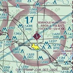
|
| Airport distance calculator |
|---|
|
|
| Sunrise and sunset |
|---|
|
Times for 07-Jan-2026
| | Local
(UTC-6) | | Zulu
(UTC) |
|---|
| Morning civil twilight | | 07:09 | | 13:09 |
| Sunrise | | 07:37 | | 13:37 |
| Sunset | | 17:29 | | 23:29 |
| Evening civil twilight | | 17:57 | | 23:57 |
|
| Current date and time |
|---|
| Zulu (UTC) | 07-Jan-2026 06:37:37 |
|---|
| Local (UTC-6) | 07-Jan-2026 00:37:37 |
|---|
|
| METAR |
|---|
| KSRE | 070615Z AUTO 00000KT 10SM CLR 09/M03 A2994 RMK AO2
|
KSNL
14nm W | 070615Z AUTO 27003KT 10SM CLR 06/00 A2995 RMK AO2 T00641002
|
|
| TAF |
|---|
KTIK
35nm W | 070200Z 0702/0808 VRB04KT 9999 SCT250 QNH2990INS BECMG 0711/0712 17010G15KT 9999 SCT200 QNH2987INS BECMG 0717/0718 18012G25KT 9999 SCT120 BKN250 QNH2989INS BECMG 0802/0803 18015G20KT 9999 BKN160 QNH2973INS TX20/0721Z TN04/0710Z
|
KOUN
38nm W | 070520Z 0706/0806 VRB05KT P6SM BKN250 FM071500 18013G18KT P6SM BKN200 FM080500 17011KT P6SM OVC150 WS005/20040KT
|
|
| NOTAMs |
|---|
NOTAMs are issued by the DoD/FAA and will open in a separate window not controlled by AirNav.
|
|

