FAA INFORMATION EFFECTIVE 14 MAY 2026
Location
| FAA Identifier: | MGN |
| Lat/Long: | 45-25-31.7000N 084-54-48.5000W
45-25.528333N 084-54.808333W
45.4254722,-84.9134722
(estimated) |
| Elevation: | 685.8 ft. / 209.0 m (surveyed) |
| Variation: | 05W (1985) |
| From city: | 3 miles E of HARBOR SPRINGS, MI |
| Time zone: | UTC -4 (UTC -5 during Standard Time) |
| Zip code: | 49740 |
Airport Operations
| Airport use: | Open to the public |
| Activation date: | 04/1940 |
| Control tower: | no |
| ARTCC: | MINNEAPOLIS CENTER |
| FSS: | LANSING FLIGHT SERVICE STATION |
| NOTAMs facility: | MGN (NOTAM-D service available) |
| Attendance: | 0800-DUSK |
| Wind indicator: | lighted |
| Segmented circle: | no |
| Lights: | ACTVT MIRL RWY 10/28 - CTAF. PAPI RWY 10 & 28 OPR CONSLY. |
| Beacon: | white-green (lighted land airport)
Operates sunset to sunrise. |
| Landing fee: | yes, LDG FEE WAIVED WITH MNM FUEL PURCHASE. |
Airport Communications
| CTAF/UNICOM: | 122.8 |
| WX AWOS-3P: | 119.925 (231-347-5231) |
| WX ASOS at PLN (10 nm NE): | 119.025 (231-539-7700) |
| WX AWOS-3PT at BFA (16 nm S): | 118.675 (231-330-8677) |
| WX AWOS-3P at CVX (17 nm SW): | 120.0 (231-237-9703) |
- APCH/DEP SVC PRVDD BY MINNEAPOLIS ARTCC ON FREQS 134.6/354.05 (PELLSTON RCAG).
Nearby radio navigation aids
| VOR radial/distance | | VOR name | | Freq | | Var |
|---|
| PLNr226/16.2 | | PELLSTON VORTAC | | 111.80 | | 06W |
Airport Services
| Fuel available: | 100LL JET-A+ |
| Parking: | tiedowns |
Runway Information
Runway 10/28
| Dimensions: | 4149 x 75 ft. / 1265 x 23 m |
| Surface: | asphalt, in fair condition |
| Weight bearing capacity: | | Single wheel: | 22.0 | | Double wheel: | 30.0 |
|
| Runway edge lights: | medium intensity |
| RUNWAY 10 | | RUNWAY 28 |
| Latitude: | 45-25.565953N | | 45-25.491885N |
| Longitude: | 084-55.290822W | | 084-54.326923W |
| Elevation: | 677.3 ft. | | 685.6 ft. |
| Traffic pattern: | left | | left |
| Runway heading: | 101 magnetic, 096 true | | 281 magnetic, 276 true |
| Displaced threshold: | 437 ft. | | 444 ft. |
| Markings: | nonprecision, in fair condition | | nonprecision, in fair condition |
| Visual slope indicator: | 4-light PAPI on right (3.50 degrees glide path) | | 4-light PAPI on left (4.00 degrees glide path)
PAPI UNUSBL BYD 2 DEGS LEFT OF CNTRLN. |
| Runway end identifier lights: | no | | no |
| Touchdown point: | yes, no lights | | yes, no lights |
| Obstructions: | 35 ft. tree, lighted, 200 ft. from runway, 112 ft. right of centerline
4 FT FENCE, 0 FT DIST, 48 FT R; 15 FT ROAD, 0 FT DIST, 75 FT R; 70 FT LGTD POLE, 180 FT DIST, 240 FT R. | | 60 ft. pole, lighted, 236 ft. from runway, 165 ft. left of centerline
4 FT FENCE, 199 FT DIST; 70 FT TREES, 0 FT DIST, 168 FT L. |
Airport Ownership and Management from official FAA records
| Ownership: | Publicly-owned |
| Owner: | HARBOR/PETOSKEY AREA AIRPORT AUTH
C/O WILLIAM P DOHM, PO BOX 274
CONWAY, MI 49722-0274
Phone 231-242-4906 |
| Manager: | MARK ZABAWA
8350 M-119
HARBOR SPRINGS, MI 49740-9077
Phone 231-206-9333
CELL. |
Additional Remarks
| - | RWY 10 APCH AREA HAS TWO 70 FT LGTD OBSTN POLES, 170 FT LEFT OF CNTRLN; +75 FT TREES ON NORTH SIDE. |
| - | FOR CD CTC MINNEAPOLIS ARTCC AT 651-463-5588. |
| - | RWY 28 APCH AREA HAS LGTD OBSTN POLES, 165 FT LEFT & 220 FT RIGHT OF CNTRLN; +80 FT TREES ADJ. |
| - | BIRDS & DEER ON & INVOF ARPT. |
| - | NOISE ABATEMENT PROCS: NO TURBOJET/TURBOFAN ACFT DEPS 2300-0700; NO LOW FLT OVR SRNDG COMMUNITY; ALL ACFT DEPG TO THE WEST TURN SOUTH OVR THE WATER AS SOON AS PRACTICAL. |
Instrument Procedures
NOTE: All procedures below are presented as PDF files. If you need a reader for these files, you should download the free Adobe Reader.NOT FOR NAVIGATION. Please procure official charts for flight.
FAA instrument procedures published for use from 14 May 2026 at 0901Z to 11 June 2026 at 0900Z.
IAPs - Instrument Approach Procedures |
|---|
| RNAV (GPS) RWY 10 | |
download (235KB) |
| RNAV (GPS) RWY 28 | |
download (243KB) |
| NOTE: Special Alternate Minimums apply | |
download |
| NOTE: Special Take-Off Minimums/Departure Procedures apply | |
download (258KB) |
Other nearby airports with instrument procedures:
KPLN - Pellston Regional/Emmet County Airport (10 nm NE)
N98 - Boyne City Municipal Airport (13 nm S)
KBFA - Boyne Mountain Airport (16 nm S)
KCVX - Charlevoix Municipal Airport (17 nm SW)
KSLH - Cheboygan County Airport (21 nm NE)
|
|

Road maps at:
MapQuest
Bing
Google
| Aerial photo |
|---|
WARNING: Photo may not be current or correct
 Photo taken 29-Sep-2007
Do you have a better or more recent aerial photo of Harbor Springs Airport that you would like to share? If so, please send us your photo.
|
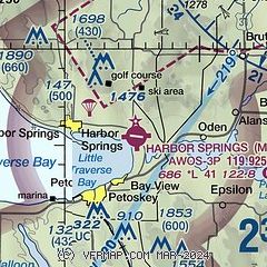
| Sectional chart |
|---|
|
| Airport distance calculator |
|---|
|
|
| Sunrise and sunset |
|---|
|
Times for 23-May-2026
| | Local
(UTC-4) | | Zulu
(UTC) |
|---|
| Morning civil twilight | | 05:26 | | 09:26 |
| Sunrise | | 06:02 | | 10:02 |
| Sunset | | 21:11 | | 01:11 |
| Evening civil twilight | | 21:46 | | 01:46 |
|
| Current date and time |
|---|
| Zulu (UTC) | 23-May-2026 11:31:41 |
|---|
| Local (UTC-4) | 23-May-2026 07:31:41 |
|---|
|
| METAR |
|---|
| KMGN | 231115Z AUTO 08008KT 10SM OVC090 11/02 A3012 RMK AO2 T01150022
|
KPLN
10nm NE | 231054Z AUTO 11009KT 10SM SCT100 11/01 A3014 RMK AO2 SLP207 T01110011
|
KBFA
16nm S | 231115Z AUTO 06005KT 10SM OVC080 12/03 A3011 RMK AO2
|
KCVX
17nm SW | 231115Z AUTO 11008KT 10SM OVC060 12/03 A3010 RMK AO2
|
|
| TAF |
|---|
KPLN
10nm NE | 230520Z 2306/2406 11008KT P6SM BKN240 WS020/13035KT FM231500 11014G24KT P6SM BKN050 FM231800 11013G24KT P6SM BKN026 FM232000 11014G25KT P6SM BKN017 FM232300 10013G24KT P6SM BKN011
|
|
| NOTAMs |
|---|
NOTAMs are issued by the DoD/FAA and will open in a separate window not controlled by AirNav.
|
|

