FAA INFORMATION EFFECTIVE 14 MAY 2026
Location
| FAA Identifier: | MDF |
| Lat/Long: | 36-29-05.1600N 099-11-39.0000W
36-29.086000N 099-11.650000W
36.4847667,-99.1941667
(estimated) |
| Elevation: | 1970 ft. / 600.5 m (surveyed) |
| Variation: | 08E (1985) |
| From city: | 3 miles N of MOORELAND, OK |
| Time zone: | UTC -5 (UTC -6 during Standard Time) |
| Zip code: | 73852 |
Airport Operations
| Airport use: | Open to the public |
| Activation date: | 09/1972 |
| Control tower: | no |
| ARTCC: | KANSAS CITY CENTER |
| FSS: | MC ALESTER FLIGHT SERVICE STATION |
| NOTAMs facility: | MLC (NOTAM-D service available) |
| Attendance: | UNATNDD
FOR AIRPORT ATTENDANT CALL DARWIN LOOMIS 580-334-5842 |
| Wind indicator: | lighted |
| Segmented circle: | no |
| Lights: | DUSK - DAWN ACTVT MIRL RY 17/35 - CTAF. |
| Beacon: | white-green (lighted land airport)
ROTG BCN OTS INDEFLY. Operates sunset to sunrise. |
Airport Communications
| CTAF/UNICOM: | 122.8 |
| WX AWOS-3 at WWR (16 nm W): | 118.425 (580-254-5217) |
- APCH/DEP CTL SVC PRVDD BY KANSAS CITY ARTCC (ZKC) ON FREQS 126.95/379.2.(GAGE RCAG)
Nearby radio navigation aids
| VOR radial/distance | | VOR name | | Freq | | Var |
|---|
| MMBr066/34.2 | | MITBEE VORTAC | | 115.60 | | 10E |
Airport Services
| Parking: | tiedowns |
| Airframe service: | NONE |
| Powerplant service: | NONE |
| Bottled oxygen: | NONE |
| Bulk oxygen: | NONE |
Runway Information
Runway 17/35
| Dimensions: | 3500 x 60 ft. / 1067 x 18 m |
| Surface: | asphalt, in fair condition
SVR DEPRESSION SOUTHEAST OF RWY 35 500 FT FM APCH END. |
| Weight bearing capacity: | |
| Runway edge lights: | medium intensity |
| RUNWAY 17 | | RUNWAY 35 |
| Latitude: | 36-29.373833N | | 36-28.798000N |
| Longitude: | 099-11.649500W | | 099-11.650500W |
| Elevation: | 1970.0 ft. | | 1966.0 ft. |
| Traffic pattern: | left | | left |
| Runway heading: | 172 magnetic, 180 true | | 352 magnetic, 000 true |
| Markings: | nonprecision, in good condition | | nonprecision, in good condition |
| Touchdown point: | yes, no lights | | no, no lights |
| Obstructions: | none | | 34 ft. trees, 288 ft. from runway, 202 ft. left of centerline, 2:1 slope to clear
34 FT TREES 288 FT FM RWY END, 202 FT LEFT OF CNTRLN. |
Airport Ownership and Management from official FAA records
| Ownership: | Publicly-owned |
| Owner: | CITY OF MOORELAND
214 S. MAIN, PO BOX 157
MOORELAND, OK 73852
Phone 580-994-5924 |
| Manager: | BOBBY KEHN
214 S. MAIN, PO BOX 157, PO BOX 157
MOORELAND, OK 73852
Phone 580-994-5924
CITY MANAGER. |
Additional Remarks
| - | TWY A CLSD INDEFLY; BACK TAXI REQUIRED FOR RY 17/35. |
| - | FOR CD CTC KANSAS CITY ARTCC AT 913-254-8508. |
Instrument Procedures
NOTE: All procedures below are presented as PDF files. If you need a reader for these files, you should download the free Adobe Reader.NOT FOR NAVIGATION. Please procure official charts for flight.
FAA instrument procedures published for use from 14 May 2026 at 0901Z to 11 June 2026 at 0900Z.
IAPs - Instrument Approach Procedures |
|---|
| RNAV (GPS) RWY 17 | |
download (182KB) |
| NOTE: Special Take-Off Minimums/Departure Procedures apply | |
download (131KB) |
Other nearby airports with instrument procedures:
KWWR - West Woodward Airport (16 nm W)
KBFK - Buffalo Municipal Airport (31 nm NW)
KAVK - Alva Regional Airport (31 nm NE)
6K4 - Fairview Municipal Airport (37 nm E)
3K8 - Comanche County Airport (45 nm N)
|
|

Road maps at:
MapQuest
Bing
Google
| Aerial photo |
|---|
WARNING: Photo may not be current or correct
 Photo taken 16-Nov-2006
Do you have a better or more recent aerial photo of Mooreland Municipal Airport that you would like to share? If so, please send us your photo.
|
| Sectional chart |
|---|
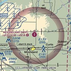
|
| Airport distance calculator |
|---|
|
|
| Sunrise and sunset |
|---|
|
Times for 03-Jun-2026
| | Local
(UTC-5) | | Zulu
(UTC) |
|---|
| Morning civil twilight | | 05:50 | | 10:50 |
| Sunrise | | 06:20 | | 11:20 |
| Sunset | | 20:49 | | 01:49 |
| Evening civil twilight | | 21:19 | | 02:19 |
|
| Current date and time |
|---|
| Zulu (UTC) | 03-Jun-2026 22:33:22 |
|---|
| Local (UTC-5) | 03-Jun-2026 17:33:22 |
|---|
|
| METAR |
|---|
KWWR
17nm NW | 032215Z AUTO 14014G23KT 10SM RA SCT037 SCT060 BKN095 26/17 A3007 RMK AO2 LTG DSNT SE THRU NW T02600168
|
KGAG
30nm W | 032216Z AUTO 17015G37KT 3SM VCTS -RA FEW040 BKN075 OVC110 20/17 A3005 RMK AO2 PK WND 19045/2155 LTG DSNT ALQDS RAB2159 P0008 T02000167 $
|
KAVK
31nm NE | 032215Z AUTO 16014G21KT 10SM SCT043 BKN050 30/20 A3002 RMK A01
|
|
| TAF |
|---|
KWWR
17nm NW | 032123Z 0321/0418 17010G20KT P6SM BKN050 TEMPO 0321/0401 VRB40KT 4SM TSRA BKN035CB FM040100 18010G15KT P6SM OVC060 TEMPO 0401/0405 VRB25KT 3SM TSRA BKN050CB FM040500 VRB05KT P6SM OVC090 PROB30 0405/0410 -TSRA BKN050CB FM041400 19010G15KT P6SM SCT030 BKN100 BKN250
|
|
| NOTAMs |
|---|
NOTAMs are issued by the DoD/FAA and will open in a separate window not controlled by AirNav.
|
|

