FAA INFORMATION EFFECTIVE 14 MAY 2026
Location
| FAA Identifier: | MO3 |
| Lat/Long: | 37-39-37.0000N 093-49-00.6000W
37-39.616667N 093-49.010000W
37.6602778,-93.8168333
(estimated) |
| Elevation: | 1042.5 ft. / 317.8 m (surveyed) |
| Variation: | 03E (2000) |
| From city: | 3 miles SW of STOCKTON, MO |
| Time zone: | UTC -5 (UTC -6 during Standard Time) |
| Zip code: | 65785 |
Airport Operations
| Airport use: | Open to the public |
| Activation date: | 07/1964 |
| Control tower: | no |
| ARTCC: | KANSAS CITY CENTER |
| FSS: | COLUMBIA FLIGHT SERVICE STATION |
| NOTAMs facility: | COU (NOTAM-D service available) |
| Attendance: | UNATNDD |
| Wind indicator: | yes |
| Segmented circle: | no |
| Lights: | SS-SR |
| Beacon: | white-green (lighted land airport)
INOP. Operates sunset to sunrise. |
Airport Communications
| CTAF: | 122.9 |
| SPRINGFIELD APPROACH: | 124.95 |
| SPRINGFIELD DEPARTURE: | 124.95 |
Nearby radio navigation aids
| VOR radial/distance | | VOR name | | Freq | | Var |
|---|
| SGFr304/29.4 | | SPRINGFIELD VORTAC | | 116.90 | | 04E |
Airport Services
| Fuel available: | 100LL |
| Parking: | tiedowns |
| Bottled oxygen: | NONE |
| Bulk oxygen: | NONE |
Runway Information
Runway 1/19
| Dimensions: | 3060 x 50 ft. / 933 x 15 m |
| Surface: | asphalt, in good condition |
| Runway edge lights: | low intensity |
| RUNWAY 1 | | RUNWAY 19 |
| Latitude: | 37-39.374453N | | 37-39.857947N |
| Longitude: | 093-49.099575W | | 093-48.920073W |
| Elevation: | 1034.6 ft. | | 1037.1 ft. |
| Traffic pattern: | left | | left |
| Runway heading: | 013 magnetic, 016 true | | 193 magnetic, 196 true |
| Markings: | nonprecision, in good condition | | nonprecision, in good condition |
| Touchdown point: | yes, no lights | | yes, no lights |
| Obstructions: | 43 ft. trees, 795 ft. from runway, 125 ft. left and right of centerline, 13:1 slope to clear | | 25 ft. pole, 288 ft. from runway, 227 ft. left of centerline, 3:1 slope to clear |
Airport Ownership and Management from official FAA records
| Ownership: | Publicly-owned |
| Owner: | OPHELIA AIR LLC
14132 E 1560 RD
STOCKTON, MO 65785
Phone 417-276-7306 |
| Manager: | DIANNA SAATHOFF
14132 E 1560 RD
STOCKTON, MO 65785
Phone 417-276-7306
CITY OF STOCKTON/CITY PUBLIC WORKS SUPERVISOR |
Additional Remarks
| - | WILDLIFE ON & INVOF ARPT. |
| - | FUEL PUMPS 100LL SELF SVC 24/7 |
| - | COURTESY CAR AVBL |
| - | FOR CD CTC SPRINGFIELD APCH AT 417-868-5620/5619. |
Instrument Procedures
NOTE: All procedures below are presented as PDF files. If you need a reader for these files, you should download the free Adobe Reader.NOT FOR NAVIGATION. Please procure official charts for flight.
FAA instrument procedures published for use from 14 May 2026 at 0901Z to 11 June 2026 at 0900Z.
IAPs - Instrument Approach Procedures |
|---|
| RNAV (GPS) RWY 01 | |
download (189KB) |
| RNAV (GPS) RWY 19 | |
download (196KB) |
| VOR/DME-A | |
download (208KB) |
| NOTE: Special Take-Off Minimums/Departure Procedures apply | |
download (425KB) |
Other nearby airports with instrument procedures:
M17 - Bolivar Municipal Airport (23 nm E)
KLLU - Lamar Municipal Airport (26 nm SW)
KNVD - Nevada Municipal Airport (26 nm NW)
KSGF - Springfield-Branson National Airport (32 nm SE)
3DW - Downtown Airport (38 nm SE)
|
|

Road maps at:
MapQuest
Bing
Google
| Aerial photo |
|---|
WARNING: Photo may not be current or correct
 Photo taken 09-Aug-2009
Do you have a better or more recent aerial photo of Stockton Lake Airport that you would like to share? If so, please send us your photo.
|
| Sectional chart |
|---|
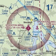
|
| Airport distance calculator |
|---|
|
|
| Sunrise and sunset |
|---|
|
Times for 07-Jun-2026
| | Local
(UTC-5) | | Zulu
(UTC) |
|---|
| Morning civil twilight | | 05:24 | | 10:24 |
| Sunrise | | 05:55 | | 10:55 |
| Sunset | | 20:34 | | 01:34 |
| Evening civil twilight | | 21:05 | | 02:05 |
|
| Current date and time |
|---|
| Zulu (UTC) | 07-Jun-2026 23:39:50 |
|---|
| Local (UTC-5) | 07-Jun-2026 18:39:50 |
|---|
|
| METAR |
|---|
KSGF
33nm SE | 072252Z 11004KT 10SM VCTS BKN100 24/22 A2979 RMK AO2 LTG DSNT SW AND W SLP074 T02440217 $
|
KGLY
42nm N | 072315Z AUTO 12007KT 10SM CLR 24/22 A2977 RMK AO2
|
KJLN
45nm SW | 072253Z 13006KT 10SM FEW023 FEW080 24/22 A2975 RMK AO2 RAB2158E40 SLP065 P0011 T02440217
|
|
| TAF |
|---|
KSGF
33nm SE | 072156Z 0722/0818 20005KT P6SM FEW011 SCT021 BKN050 TEMPO 0722/0802 4SM TSRA BR OVC025CB FM080700 17009KT P6SM -SHRA BKN110 FM081300 18009KT 4SM SHRA BKN035 PROB30 0813/0817 4SM TSRA BR OVC025CB
|
|
| NOTAMs |
|---|
NOTAMs are issued by the DoD/FAA and will open in a separate window not controlled by AirNav.
|
|

