FAA INFORMATION EFFECTIVE 09 JULY 2026
Location
| FAA Identifier: | ENA |
| Lat/Long: | 60-34-23.8000N 151-14-41.4000W
60-34.396667N 151-14.690000W
60.5732778,-151.2448333
(estimated) |
| Elevation: | 99.6 ft. / 30.4 m (surveyed) |
| Variation: | 15E (2020) |
| Time zone: | UTC -8 (UTC -9 during Standard Time) |
| Zip code: | 99611 |
Airport Operations
| Airport use: | Open to the public |
| Activation date: | 05/1947 |
| Control tower: | yes |
| ARTCC: | ANCHORAGE CENTER |
| FSS: | KENAI FLIGHT SERVICE STATION (on field) [907-283-7211] |
| NOTAMs facility: | ENA (NOTAM-D service available) |
| Attendance: | MON-FRI 0800-1700 |
| Pattern altitude: | TPA: RWY 02R/20L & 02W/20W PAT ALT 500 FT AGL. |
| Wind indicator: | lighted |
| Segmented circle: | yes |
| Lights: | ACTVT REIL RWY 02L; VASI RWY 02L & 20R - CTAF. WHEN TWR CLSD ACTVT & INCR INTST HIRL RWY 02L/20R - KENAI FSS. WHEN TWR CLSD ACTVT MALSR RWY 20R - CTAF. |
| Beacon: | white-green (lighted land airport)
Operates sunset to sunrise. |
| Fire and rescue: | ARFF index A |
Airport Communications
| CTAF: | 121.3 |
| ATIS: | 133.35 |
| WX ASOS: | 133.35 (907-283-6513) |
| KENAI GROUND: | 118.75 [0600-2200 MAY 1 - SEP 30; 0700-2100 OCT 1 - APR 30] |
| KENAI TOWER: | 121.3 239.3 [0600-2200 MAY 1 - SEP 30; 0700-2100 OCT 1 - APR 30] |
| WX AWOS-3P at SXQ (8 nm SE): | 135.45 (907-262-8431) |
- APCH/DEP SVC PRVDD BY ANCHORAGE ARTCC ON FREQS 125.7/379.1 (KENAI RCAG).
- COMMUNICATIONS PRVDD BY KENAI FSS ON FREQ 122.65.
Nearby radio navigation aids
| VOR radial/distance | | VOR name | | Freq | | Var |
|---|
| ENAr191/2.9 | | KENAI VOR/DME | | 117.60 | | 19E |
Airport Services
| Fuel available: | 100LL JET-A |
| Parking: | tiedowns |
| Airframe service: | MINOR |
| Powerplant service: | MINOR |
Runway Information
Runway 2L/20R
| Dimensions: | 7855 x 150 ft. / 2394 x 46 m |
| Surface: | asphalt/grooved, in fair condition |
| Weight bearing capacity: | | Single wheel: | 75.0 | | Double wheel: | 150.0 | | Double tandem: | 250.0 |
|
| Runway edge lights: | high intensity |
| RUNWAY 2L | | RUNWAY 20R |
| Latitude: | 60-33.782993N | | 60-34.887538N |
| Longitude: | 151-15.507640W | | 151-14.156195W |
| Elevation: | 89.8 ft. | | 97.9 ft. |
| Traffic pattern: | right | | left |
| Runway heading: | 016 magnetic, 031 true | | 196 magnetic, 211 true |
| Displaced threshold: | 280 ft. | | no |
| Declared distances: | TORA:7855 TODA:7855 ASDA:7855 LDA:7575 | | TORA:7855 TODA:7855 ASDA:7575 LDA:7575 |
| Markings: | precision, in fair condition | | precision, in fair condition |
| Visual slope indicator: | 4-box VASI on left (3.00 degrees glide path) | | 4-box VASI on left (3.00 degrees glide path) |
| RVR equipment: | rollout | | touchdown |
| Approach lights: | | | MALSR: 1,400 foot medium intensity approach lighting system with runway alignment indicator lights |
| Runway end identifier lights: | yes | | |
| Touchdown point: | yes, no lights | | yes, no lights |
| Instrument approach: | | | ILS/DME |
Helipad H1
| Dimensions: | 55 x 55 ft. / 17 x 17 m |
| Surface: | asphalt |
| Latitude: | 60-34.236333N | | |
| Longitude: | 151-14.460333W | | |
| Elevation: | 92.0 ft. | | |
| Traffic pattern: | left | | left |
Helipad H2
| Dimensions: | 55 x 55 ft. / 17 x 17 m |
| Surface: | asphalt |
| Latitude: | 60-33.959333N | | |
| Longitude: | 151-14.801000W | | |
| Elevation: | 91.0 ft. | | |
| Traffic pattern: | left | | left |
Runway 2R/20L
| Dimensions: | 1980 x 75 ft. / 604 x 23 m |
| Surface: | gravel, in good condition |
| Runway edge markings: | OUTLINED WITH CONES. |
| Operational restrictions: | RWY 02R/20L NOT AVBL FOR PART 121/PART 380 OPS WITH SKED PAX CARRYING OPS MORE THAN 9 PAX SEATS AND NON-SKED PAX CARRYING OPS MORE THAN 30 PAX SEATS. |
| RUNWAY 2R | | RUNWAY 20L |
| Latitude: | 60-34.498775N | | 60-34.777030N |
| Longitude: | 151-14.297425W | | 151-13.956250W |
| Elevation: | 98.1 ft. | | 99.6 ft. |
| Traffic pattern: | left | | left |
| Runway heading: | 016 magnetic, 031 true | | 196 magnetic, 211 true |
| Touchdown point: | yes, no lights | | yes, no lights |
Runway 2W/20W
| Dimensions: | 4600 x 240 ft. / 1402 x 73 m |
| Surface: | water, in good condition |
| Operational restrictions: | CLSD TO OPS NOV-APR. RWY 02W/20W NOT AVBL FOR PART 121/PART 380 OPS WITH SKED PAX CARRYING OPS MORE THAN 9 PAX SEATS AND NON-SKED PAX CARRYING OPS MORE THAN 30 PAX SEATS. NOISE ABATEMENT: 02W ARR & 20W DEP MAKE FNL APCH & CROSS WIND TURNS S OF BEACHLINE UNLESS AUTH BY ATC. WATER LDG AREA & TWY CHNL NOT VSB FM ATCT. |
| RUNWAY 2W | | RUNWAY 20W |
| Latitude: | 60-34.342167N | | 60-34.989167N |
| Longitude: | 151-15.156333W | | 151-14.366167W |
| Elevation: | 84.0 ft. | | 84.0 ft. |
| Traffic pattern: | left | | right |
| Markings: | none, in good condition | | none, in good condition |
| Touchdown point: | yes, no lights | | yes, no lights |
Airport Ownership and Management from official FAA records
| Ownership: | Publicly-owned |
| Owner: | CITY OF KENAI
210 FIDALGO ST
KENAI, AK 99611
Phone 907-283-7951 |
| Manager: | MARY BONDURANT
305 N WILLOW SUITE 200
KENAI, AK 99611
Phone 907-283-7951 |
Additional Remarks
| A39-02L/20R | PCR VALUE: 461/F/B/X/U |
| - | TSNT & COML TIE DOWN SLIPS AVBL END OF WATER CANAL. |
| - | KENAI FSS LCL - 283-7211. |
| - | WX CAMERA AVBL ON INTERNET AT HTTPS://WEATHERCAMS.FAA.GOV/ |
| - | EXC WX DVRSN UNSKED ACFT OVR 12500 LBS 48 HR PPR. |
| - | TWY A, B & E PCN 48; TWY C PCN 59; TWY F PCN 43; TWY D, J, K & L PCN 34. |
| - | ARPT SAND GRADATION LRGR THAN FAA RCMDD SEE AC150/5200-30 |
| - | TSNT PRKG S TRML RAMP; HEL PRKG N TRML RAMP. LNDG FEE OVR 4000 LB. |
| - | BIRDS 10 NM RADIUS SPRING-FALL. |
| - | PTNS OF TRML RAMP, TWY G & H NOT VSB FM ATCT. |
| - | SPB CTLD BY KENAI ATCT DURG OPS HRS. WHEN KENAI ATCT CLSD WX AVBL FM KENAI ATIS OR KENAI FSS. NOISE ABATEMENT PROC IN EFCT - AMGR. |
Instrument Procedures
NOTE: All procedures below are presented as PDF files. If you need a reader for these files, you should download the free Adobe Reader.NOT FOR NAVIGATION. Please procure official charts for flight.
FAA instrument procedures published for use from 09 July 2026 at 0901Z to 06 August 2026 at 0900Z.
IAPs - Instrument Approach Procedures |
|---|
| ILS Y OR LOC Y RWY 20R | |
download (290KB) |
| ILS Z OR LOC Z RWY 20R | |
download (256KB) |
| RNAV (GPS) RWY 02L | |
download (252KB) |
| RNAV (GPS) RWY 20R | |
download (251KB) |
| VOR RWY 02L | |
download (264KB) |
| VOR RWY 20R | |
download (241KB) |
| NOTE: Special Alternate Minimums apply | |
download (61KB) |
| NOTE: Special Take-Off Minimums/Departure Procedures apply | |
download (293KB) |
Other nearby airports with instrument procedures:
PASX - Soldotna Airport (8 nm SE)
PANC - Ted Stevens Anchorage International Airport (51 nm NE)
PAMR - Merrill Field Airport (56 nm NE)
PAHO - Homer Airport (56 nm S)
PAED - Elmendorf Air Force Base (58 nm NE)
|
|

Road maps at:
MapQuest
Bing
Google
| Aerial photo |
|---|
WARNING: Photo may not be current or correct
 Taken in 2007
looking west.
Taken in 2007
looking west.
Do you have a better or more recent aerial photo of Kenai Municipal Airport that you would like to share? If so, please send us your photo.
|
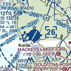
| Sectional chart |
|---|
|
 Download PDF
of official airport diagram from the FAA
| Airport distance calculator |
|---|
|
|
| Sunrise and sunset |
|---|
|
Times for 16-Jul-2026
| | Local
(UTC-8) | | Zulu
(UTC) |
|---|
| Morning civil twilight | | 03:44 | | 11:44 |
| Sunrise | | 05:07 | | 13:07 |
| Sunset | | 23:15 | | 07:15 |
| Evening civil twilight | | 00:38 | | 08:38 |
|
| Current date and time |
|---|
| Zulu (UTC) | 16-Jul-2026 10:15:20 |
|---|
| Local (UTC-8) | 16-Jul-2026 02:15:20 |
|---|
|
| METAR |
|---|
| PAEN | 160953Z AUTO 18008KT 10SM CLR 09/05 A3005 RMK AO2 SLP177 T00940050
|
PASX
8nm SE | 160956Z AUTO 21006KT 10SM CLR 09/04 A3005 RMK AO2 SLP183 T00940044 TSNO
|
|
| TAF |
|---|
| PAEN | 160541Z 1606/1706 20012G20KT P6SM SKC FM160800 17008KT P6SM FEW050 SCT200 FM161400 19005KT P6SM FEW030 OVC050 FM161800 05006KT 5SM -RA BR BKN025 OVC040
|
|
| NOTAMs |
|---|
NOTAMs are issued by the DoD/FAA and will open in a separate window not controlled by AirNav.
|
|


