FAA INFORMATION EFFECTIVE 19 MARCH 2026
Location
| FAA Identifier: | SXQ |
| Lat/Long: | 60-28-30.5000N 151-02-22.7000W
60-28.508333N 151-02.378333W
60.4751389,-151.0396389
(estimated) |
| Elevation: | 113.4 ft. / 34.6 m (surveyed) |
| Variation: | 15E (2020) |
| From city: | 1 mile SE of SOLDOTNA, AK |
| Time zone: | UTC -8 (UTC -9 during Standard Time) |
| Zip code: | 99669 |
Airport Operations
| Airport use: | Open to the public |
| Activation date: | 10/1962 |
| Control tower: | no |
| ARTCC: | ANCHORAGE CENTER |
| FSS: | KENAI FLIGHT SERVICE STATION [907-283-7211] |
| NOTAMs facility: | SXQ (NOTAM-D service available) |
| Attendance: | 0700-1600 |
| Pattern altitude: | 906.4 ft. MSL |
| Wind indicator: | lighted |
| Segmented circle: | yes |
| Lights: | ACTVT PAPI RWY 07 & 25; MIRL RWY 07/25; WINDSOCKS - CTAF. |
| Beacon: | white-green (lighted land airport)
Operates sunset to sunrise. |
| Landing fee: | yes, 12500 LBS & OVR. |
Airport Communications
| CTAF: | 122.5 |
| WX AWOS-3P: | 135.45 (907-262-8431) |
| WX ASOS at ENA (8 nm NW): | 133.35 (907-283-6513) |
- APCH/DEP SVC PRVDD BY ANCHORAGE ARTCC ON FREQS 125.7/379.1 (KENAI RCAG).
- COMMUNICATIONS PRVDD BY KENAI FSS ON FREQ 122.35.
Nearby radio navigation aids
| VOR radial/distance | | VOR name | | Freq | | Var |
|---|
| ENAr132/9.5 | | KENAI VOR/DME | | 117.60 | | 19E |
Airport Services
| Fuel available: | 100LL JET-A
A:0700-1600 - 907-262-5388; CALL OUT FEE AFT HR - 907-420-7153.
100LL:AVBL 24 HR WITH CREDIT CARD. |
| Parking: | tiedowns |
| Airframe service: | MAJOR |
| Powerplant service: | MAJOR |
Runway Information
Runway 7/25
| Dimensions: | 5001 x 130 ft. / 1524 x 40 m |
| Surface: | asphalt, in fair condition |
| Weight bearing capacity: | |
| Runway edge lights: | medium intensity |
| RUNWAY 7 | | RUNWAY 25 |
| Latitude: | 60-28.497688N | | 60-28.497268N |
| Longitude: | 151-03.125393W | | 151-01.462658W |
| Elevation: | 95.4 ft. | | 112.2 ft. |
| Traffic pattern: | right | | left |
| Runway heading: | 075 magnetic, 090 true | | 255 magnetic, 270 true |
| Markings: | nonprecision, in good condition | | nonprecision, in good condition |
| Visual slope indicator: | 4-light PAPI on right (3.00 degrees glide path) | | 4-light PAPI on right (3.00 degrees glide path) |
| Touchdown point: | yes, no lights | | yes, no lights |
| Obstructions: | 45 ft. trees, 1470 ft. from runway, 390 ft. right of centerline, 28:1 slope to clear | | 50 ft. trees, 2265 ft. from runway, 118 ft. left of centerline, 41:1 slope to clear |
Runway 7S/25S
| Dimensions: | 2300 x 60 ft. / 701 x 18 m |
| Surface: | gravel/dirt, in fair condition |
| RUNWAY 7S | | RUNWAY 25S |
| Latitude: | 60-28.533770N | | 60-28.533603N |
| Longitude: | 151-02.942470W | | 151-02.177615W |
| Elevation: | 94.9 ft. | | 99.6 ft. |
| Traffic pattern: | left | | left |
| Runway heading: | 075 magnetic, 090 true | | 255 magnetic, 270 true |
| Markings: | none, in poor condition | | none, in poor condition |
| Touchdown point: | yes, no lights | | yes, no lights |
Airport Ownership and Management from official FAA records
| Ownership: | Publicly-owned |
| Owner: | CITY OF SOLDOTNA
177 NORTH BIRCH ST
SOLDOTNA, AK 99669
Phone 907-262-9107 |
| Manager: | KYLE KORNELIS
177 NORTH BIRCH ST
SOLDOTNA, AK 99669
Phone 907-398-1440
907-262-4672. |
Additional Remarks
| - | LRG CARGO ACFT USE E RAMP FOR PRKG/UNLOADING. |
| - | SIMUL/PARL OPS NA; SEQ - CTAF. |
| - | GRVL LNDG AREA N SIDE & PARL TO RWY 07/25; MRKD BY CONES; NOT MNTND IN WINTER. |
| - | TSNT PRKG S OF TRML BLDG; ROWS 26-28 & 40-44. |
| - | W APRON NOT MNTND. |
| - | RWY COND UNMNT; RCMD VISUAL INSP BFR LNDG. |
| - | ULTRALIGHT ACFT INVOF ARPT, NO ULTRALIGHT STRIP. |
| - | WX CAMERA AVBL ON INTERNET AT HTTPS://WEATHERCAMS.FAA.GOV |
Instrument Procedures
NOTE: All procedures below are presented as PDF files. If you need a reader for these files, you should download the free Adobe Reader.NOT FOR NAVIGATION. Please procure official charts for flight.
FAA instrument procedures published for use from 19 March 2026 at 0901Z to 16 April 2026 at 0900Z.
IAPs - Instrument Approach Procedures |
|---|
| RNAV (GPS) RWY 07 | |
download (216KB) |
| RNAV (GPS) RWY 25 | |
download (203KB) |
| VOR-A | |
download (171KB) |
| NOTE: Special Alternate Minimums apply | |
download (173KB) |
| NOTE: Special Take-Off Minimums/Departure Procedures apply | |
download (313KB) |
Other nearby airports with instrument procedures:
PAEN - Kenai Municipal Airport (8 nm NW)
PAHO - Homer Airport (51 nm S)
PANC - Ted Stevens Anchorage International Airport (52 nm NE)
PAWD - Seward Airport (53 nm SE)
PAMR - Merrill Field Airport (56 nm NE)
|
|

Road maps at:
MapQuest
Bing
Google
| Aerial photo |
|---|
WARNING: Photo may not be current or correct
 Photo by LL
Photo taken 04-Jul-2016
looking east.
Photo by LL
Photo taken 04-Jul-2016
looking east.
Do you have a better or more recent aerial photo of Soldotna Airport that you would like to share? If so, please send us your photo.
|
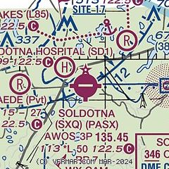
| Sectional chart |
|---|
|
| Airport distance calculator |
|---|
|
|
| Sunrise and sunset |
|---|
|
Times for 25-Mar-2026
| | Local
(UTC-8) | | Zulu
(UTC) |
|---|
| Morning civil twilight | | 07:08 | | 15:08 |
| Sunrise | | 07:50 | | 15:50 |
| Sunset | | 20:30 | | 04:30 |
| Evening civil twilight | | 21:12 | | 05:12 |
|
| Current date and time |
|---|
| Zulu (UTC) | 25-Mar-2026 11:37:16 |
|---|
| Local (UTC-8) | 25-Mar-2026 03:37:16 |
|---|
|
| METAR |
|---|
| PASX | 251056Z AUTO 04003KT 10SM FEW075 BKN090 M08/M16 A3002 RMK AO2 SLP174 T10781161 FZRANO TSNO
|
PAEN
8nm NW | 251053Z AUTO 01016KT 10SM CLR M07/M18 A3002 RMK AO2 PK WND 01026/1001 SLP169 T10671178
|
|
| TAF |
|---|
PAEN
8nm NW | 250521Z 2506/2606 02015KT P6SM SKC TEMPO 2506/2509 02015G25KT FM251400 02008KT P6SM SKC FM252200 02012G20KT P6SM SKC
|
|
| NOTAMs |
|---|
NOTAMs are issued by the DoD/FAA and will open in a separate window not controlled by AirNav.
|
|

