FAA INFORMATION EFFECTIVE 19 MARCH 2026
Location
| FAA Identifier: | OME |
| Lat/Long: | 64-30-45.1980N 165-26-39.8180W
64-30.753300N 165-26.663633W
64.5125550,-165.4443939
(estimated) |
| Elevation: | 40.6 ft. / 12.4 m (surveyed) |
| Variation: | 11E (2015) |
| From city: | 2 miles W of NOME, AK |
| Time zone: | UTC -8 (UTC -9 during Standard Time) |
| Zip code: | 99762 |
Airport Operations
| Airport use: | Open to the public |
| Control tower: | no |
| ARTCC: | ANCHORAGE CENTER |
| FSS: | NOME FLIGHT SERVICE STATION (on field) [ 443-2291 (local call from the AIRPORT)] |
| Alternate FSS: | FAI FAIRBANKS FLIGHT SERVICE STATION [1-866-248-6516] |
| NOTAMs facility: | OME (NOTAM-D service available) |
| Attendance: | 0700-1830 |
| Pattern altitude: | 1140.6 ft. MSL |
| Wind indicator: | yes |
| Segmented circle: | yes |
| Lights: | ACTVT MALSR RWY 28; REIL RWY 03 &10; PAPI RWY 03, 10, & 28; HIRL RWY 10/28; MIRL RWY 03/21 - CTAF. PAPI RWY 21 PAPI OPR CONSLY. |
| Beacon: | white-green (lighted land airport)
Operates sunset to sunrise. |
| Fire and rescue: | ARFF index B |
| Airline operations: | ARFF SVC DURG ACR OPS ONLY; ACR OPS MORE THAN 30 PAX SEATS PPR IN WRITING - AMGR PO BOX 1048 NOME AK 99762. |
| International operations: | customs landing rights airport |
Airport Communications
| CTAF: | 123.6 |
| WX ASOS: | 119.925 (907-443-4818) |
- APCH/DEP SVC PRVDD BY ANCHORAGE ARTCC ON FREQS 133.3/290.4 (NOME RCAG).
- NUMEROUS UNLGTD TWRS 150 FT AGL 3 MILES EAST.
- OME AFIS ON FREQUENCY 119.925. OPERATES SAME HRS AS OME FSS, 0715-2245; OT CTC FAIRBANKS FSS.
- COMMUNICATIONS PRVDD BY NOME FSS ON FREQ 123.6 (CTAF).
Nearby radio navigation aids
| VOR radial/distance | | VOR name | | Freq | | Var |
|---|
| OMEr277/5.2 | | NOME VOR/DME | | 115.00 | | 11E |
| NDB name | | Hdg/Dist | | Freq | | Var | | ID |
|---|
| FORT DAVIS | | 277/3.5 | | 529 | | 11E | | FDV | ..-. -.. ...- |
Airport Services
| Fuel available: | 100LL JET-A JET-A1+
100LL:AVBL HRS VRB - AFT HR AMGR. |
| Parking: | hangars |
| Airframe service: | MINOR |
| Powerplant service: | MINOR |
Runway Information
Runway 3/21
| Dimensions: | 6176 x 150 ft. / 1882 x 46 m |
| Surface: | asphalt/grooved, in good condition |
| Weight bearing capacity: | | Single wheel: | 120.0 | | Double wheel: | 250.0 | | Double tandem: | 550.0 |
|
| Runway edge lights: | medium intensity
30 IN ABV GND. |
| RUNWAY 3 | | RUNWAY 21 |
| Latitude: | 64-30.434065N | | 64-31.190582N |
| Longitude: | 165-27.108445W | | 165-25.544625W |
| Elevation: | 15.6 ft. | | 40.5 ft. |
| Traffic pattern: | left | | left |
| Runway heading: | 031 magnetic, 042 true | | 211 magnetic, 222 true |
| Displaced threshold: | 600 ft. | | 601 ft. |
| Declared distances: | TORA:6176 TODA:6176 ASDA:6176 LDA:5576 | | TORA:5576 TODA:5576 ASDA:5576 LDA:5576 |
| Markings: | nonprecision, in good condition | | nonprecision, in good condition |
| Visual slope indicator: | 4-light PAPI on left (3.00 degrees glide path) | | 4-light PAPI on left (3.00 degrees glide path)
PAPI UNUSBL BYD 2 NM FM THR DUE TO RAPIDLY RISING TRRN. |
| Runway end identifier lights: | yes | | |
| Touchdown point: | yes, no lights | | yes, no lights |
| Obstructions: | 37 ft. road, 528 ft. from runway, 336 ft. left of centerline, 8:1 slope to clear | | 69 ft. pole, 2150 ft. from runway, 75 ft. left of centerline, 28:1 slope to clear |
Runway 10/28
| Dimensions: | 6009 x 150 ft. / 1832 x 46 m |
| Surface: | asphalt/grooved, in good condition |
| Weight bearing capacity: | | Single wheel: | 150.0 | | Double wheel: | 250.0 | | Double tandem: | 550.0 |
|
| Runway edge lights: | high intensity
30 IN ABV GND. |
| RUNWAY 10 | | RUNWAY 28 |
| Latitude: | 64-30.859112N | | 64-30.525917N |
| Longitude: | 165-28.086513W | | 165-25.933475W |
| Elevation: | 19.3 ft. | | 24.8 ft. |
| Traffic pattern: | left | | left |
| Runway heading: | 099 magnetic, 110 true | | 279 magnetic, 290 true |
| Declared distances: | TORA:6009 TODA:6009 ASDA:6009 LDA:6009 | | TORA:6009 TODA:6009 ASDA:6009 LDA:6009 |
| Markings: | precision, in good condition | | precision, in good condition |
| Visual slope indicator: | 4-light PAPI on left (3.00 degrees glide path) | | 4-light PAPI on left (3.00 degrees glide path) |
| RVR equipment: | rollout | | touchdown |
| Approach lights: | | | MALSR: 1,400 foot medium intensity approach lighting system with runway alignment indicator lights |
| Runway end identifier lights: | yes | | |
| Touchdown point: | yes, no lights | | yes, no lights |
| Instrument approach: | MLS | | ILS/DME |
| Obstructions: | 18 ft. hill, 300 ft. from runway, 250 ft. right of centerline, 5:1 slope to clear | | 80 ft. hill, 2500 ft. from runway, 28:1 slope to clear |
Airport Ownership and Management from official FAA records
| Ownership: | Publicly-owned |
| Owner: | ALASKA DOT&PF NORTHERN REGION
2301 PEGER RD
FAIRBANKS, AK 99709
Phone 907-443-2500 |
| Manager: | GEORGE KOST
BOX 1048
NOME, AK 99762
Phone 907-443-2500 |
Additional Remarks
| A39-03/21 | PCR VALUE: 719/F/A/X/T |
| A39-10/28 | PCR VALUE: 719/F/A/X/T |
| A30A-21 | APCH SLOPE 34:1 DUE TO 69 FT POLE 1550 FT FM DTHR. |
| A30A-03 | APCH SLOPE 26:1 DUE TO 35 FT ROAD 1128 FT FM DTHR. |
| E60-28 | ENGINEERED MATERIAL ARRESTING SYSTEM (EMAS) 200 FT IN LENGTH BY 170 FT IN WIDTH LCTD AT THE DER 28 |
| - | ARPT SAND LRGR GRADATION THAN FAA RCMDD/SEE AC150/5200-30. |
| - | 130 FT LGTD WIND TURBINE TWRS 4 NM NNW. |
| - | WX CAMERA AVBL ON INTERNET AT HTTPS://WEATHERCAMS.FAA.GOV |
| - | TSA REG; SEE 49 CFR 1542. GATES & DOORS MUST BE SECURED H24. INFO - AMGR. |
| - | AIRFIELD MAINT SVCS AVBL 0700 -1730; AFT HR - AMGR. |
| - | ANG: AVN OPERG FAC - ANG HNGR 907-387-1800. OPS 1700-0100Z; LTD MAINT & SVCS AVBL. |
| - | BIRDS INVOF ARPT SEP-OCT & MAY-JUN. |
| - | RWY 21 & 28 ARR MNTN TFC PAT ALT TIL FNL. |
Instrument Procedures
NOTE: All procedures below are presented as PDF files. If you need a reader for these files, you should download the free Adobe Reader.NOT FOR NAVIGATION. Please procure official charts for flight.
FAA instrument procedures published for use from 19 March 2026 at 0901Z to 16 April 2026 at 0900Z.
IAPs - Instrument Approach Procedures |
|---|
| ILS Y OR LOC Y RWY 28 | |
download (258KB) |
| ILS Z OR LOC Z RWY 28 | |
download (349KB) |
| RNAV (GPS) RWY 03 | |
download (193KB) |
| RNAV (GPS) RWY 10 | |
download (225KB) |
| RNAV (GPS) RWY 28 | |
download (228KB) |
| LOC/DME BC RWY 10 | |
download (323KB) |
| VOR RWY 28 | |
download (320KB) |
| NDB-A | |
download (191KB) |
| NOTE: Special Alternate Minimums apply | |
download (61KB) |
| NOTE: Special Take-Off Minimums/Departure Procedures apply | |
download |
Other nearby airports with instrument procedures:
PATE - Teller Airport (49 nm NW)
PAWM - White Mountain Airport (53 nm E)
PFKT - Brevig Mission Airport (56 nm NW)
PAGL - Golovin Airport (63 nm E)
PFEL - Elim Airport (82 nm E)
|
|

Road maps at:
MapQuest
Bing
Google
| Aerial photo |
|---|
WARNING: Photo may not be current or correct
 Photo by Bob Webster
Photo taken 31-Jul-2010
Photo by Bob Webster
Photo taken 31-Jul-2010
Do you have a better or more recent aerial photo of Nome Airport that you would like to share? If so, please send us your photo.
|
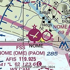
| Sectional chart |
|---|
|
 Download PDF
of official airport diagram from the FAA
| Airport distance calculator |
|---|
|
|
| Sunrise and sunset |
|---|
|
Times for 29-Mar-2026
| | Local
(UTC-8) | | Zulu
(UTC) |
|---|
| Morning civil twilight | | 07:40 | | 15:40 |
| Sunrise | | 08:30 | | 16:30 |
| Sunset | | 21:43 | | 05:43 |
| Evening civil twilight | | 22:33 | | 06:33 |
|
| Current date and time |
|---|
| Zulu (UTC) | 29-Mar-2026 08:24:15 |
|---|
| Local (UTC-8) | 29-Mar-2026 00:24:15 |
|---|
|
| METAR |
|---|
| PAOM | 290753Z AUTO 09011KT 10SM BKN055 OVC075 M06/M07 A3008 RMK AO2 SLP187 T10561072 TSNO
|
|
| TAF |
|---|
| PAOM | 290540Z 2906/3006 09012KT P6SM BKN050 OVC070 FM292300 06006KT P6SM SCT070
|
|
| NOTAMs |
|---|
NOTAMs are issued by the DoD/FAA and will open in a separate window not controlled by AirNav.
|
|


