FAA INFORMATION EFFECTIVE 19 FEBRUARY 2026
Location
| FAA Identifier: | KTS |
| Lat/Long: | 65-19-52.8000N 166-27-56.6000W
65-19.880000N 166-27.943333W
65.3313333,-166.4657222
(estimated) |
| Elevation: | 38.1 ft. / 11.6 m (surveyed) |
| Variation: | 09E (2020) |
| Time zone: | UTC -9 (UTC -8 during Daylight Saving Time) |
| Zip code: | 99785 |
Airport Operations
| Airport use: | Open to the public |
| Control tower: | no |
| ARTCC: | ANCHORAGE CENTER |
| FSS: | NOME FLIGHT SERVICE STATION [ 443-2291 (local call from the AIRPORT)] |
| Alternate FSS: | FAI FAIRBANKS FLIGHT SERVICE STATION [1-866-248-6516] |
| NOTAMs facility: | KTS (NOTAM-D service available) |
| Attendance: | UNATNDD |
| Wind indicator: | lighted |
| Segmented circle: | yes |
| Lights: | ACTVT MIRL RWY 05/23 & 12/30 - CTAF. |
| Beacon: | white-green (lighted land airport)
Operates sunset to sunrise. |
Airport Communications
| CTAF: | 123.0 |
| WX AWOS-3P: | 121.550 (907-642-2166) |
| WX AWOS-3P at TER (6 nm SE): | 118.375 (907-642-2301) |
- APCH/DEP SVC PRVDD BY ANCHORAGE ARTCC ON FREQS 133.3/290.4 (NOME RCAG).
- COMMUNICATIONS PRVDD BY NOME FSS ON FREQ 135.6 (BREVIG MISSION RCO).
Nearby radio navigation aids
| NDB name | | Hdg/Dist | | Freq | | Var | | ID |
|---|
| TIN CITY | | 101/38.9 | | 347 | | 10E | | TNC | - -. -.-. |
Airport Services
Runway Information
Runway 12/30
| Dimensions: | 2990 x 100 ft. / 911 x 30 m |
| Surface: | gravel, in good condition |
| Runway edge lights: | medium intensity |
| Runway edge markings: | RWY 12/30 MARKED WITH LIGHTS AND PLASTIC MARKERS. |
| RUNWAY 12 | | RUNWAY 30 |
| Latitude: | 65-20.007442N | | 65-19.694378N |
| Longitude: | 166-28.311835W | | 166-27.408658W |
| Elevation: | 36.5 ft. | | 34.8 ft. |
| Traffic pattern: | left | | left |
| Runway heading: | 121 magnetic, 130 true | | 301 magnetic, 310 true |
| Markings: | NSTD | | |
| Touchdown point: | yes, no lights | | yes, no lights |
| Obstructions: | none | | 28 ft. pole, 1011 ft. from runway, 401 ft. left of centerline, 36:1 slope to clear |
Runway 5/23
| Dimensions: | 2110 x 75 ft. / 643 x 23 m |
| Surface: | gravel, in good condition |
| Runway edge lights: | medium intensity |
| Runway edge markings: | RWY 05/23 MARKED WITH LIGHTS AND PLASTIC MARKERS. |
| RUNWAY 5 | | RUNWAY 23 |
| Latitude: | 65-19.819588N | | 65-20.019698N |
| Longitude: | 166-28.398842W | | 166-27.722952W |
| Elevation: | 34.0 ft. | | 38.1 ft. |
| Traffic pattern: | left | | left |
| Runway heading: | 046 magnetic, 055 true | | 226 magnetic, 235 true |
| Markings: | NSTD | | |
| Touchdown point: | yes, no lights | | yes, no lights |
| Obstructions: | none | | 1215 ft. hill, 9500 ft. from runway, 8:1 slope to clear |
Airport Ownership and Management from official FAA records
| Ownership: | Publicly-owned |
| Owner: | ALASKA DOT&PF NORTHERN REGION
2301 PEGER RD
FAIRBANKS, AK 99701
Phone 907-451-2200 |
| Manager: | GEORGE KOST
BOX 1048
NOME, AK 99762
Phone 907-443-2500 |
Additional Remarks
| - | RY COND NOT MONITORED; RCMD VISUAL INSPECTION PRIOR TO LDNG. |
Instrument Procedures
NOTE: All procedures below are presented as PDF files. If you need a reader for these files, you should download the free Adobe Reader.NOT FOR NAVIGATION. Please procure official charts for flight.
FAA instrument procedures published for use from 19 February 2026 at 0901Z to 19 March 2026 at 0900Z.
IAPs - Instrument Approach Procedures |
|---|
| RNAV (GPS) RWY 12 **CHANGED** | |
download (228KB) |
| RNAV (GPS) RWY 30 **CHANGED** | |
download (240KB) |
| NOTE: Special Alternate Minimums apply | |
download (149KB) |
|
|---|
| BREVIG THREE (OBSTACLE) (RNAV) | |
download (200KB) |
| NOTE: Special Take-Off Minimums/Departure Procedures apply | |
download (387KB) |
Other nearby airports with instrument procedures:
PATE - Teller Airport (6 nm SE)
PATC - Tin City LRRS Airport (39 nm W)
PAIW - Wales Airport (44 nm NW)
PAOM - Nome Airport (56 nm SE)
PASH - Shishmaref Airport (56 nm N)
|
|

Road maps at:
MapQuest
Bing
Google
| Aerial photo |
|---|
WARNING: Photo may not be current or correct
 Photo by Thomas Travis
Photo taken 27-Oct-2005
Photo by Thomas Travis
Photo taken 27-Oct-2005
Do you have a better or more recent aerial photo of Brevig Mission Airport that you would like to share? If so, please send us your photo.
|
| Sectional chart |
|---|
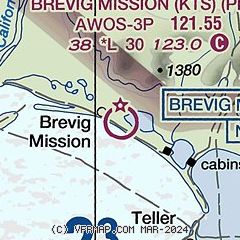
|
| Airport distance calculator |
|---|
|
|
| Sunrise and sunset |
|---|
|
Times for 02-Mar-2026
| | Local
(UTC-9) | | Zulu
(UTC) |
|---|
| Morning civil twilight | | 08:23 | | 17:23 |
| Sunrise | | 09:13 | | 18:13 |
| Sunset | | 19:23 | | 04:23 |
| Evening civil twilight | | 20:13 | | 05:13 |
|
| Current date and time |
|---|
| Zulu (UTC) | 03-Mar-2026 03:22:55 |
|---|
| Local (UTC-9) | 02-Mar-2026 18:22:55 |
|---|
|
| METAR |
|---|
| PFKT | 030256Z AUTO 03007KT 8SM SCT046 M18/M21 A3045 RMK AO2 SLP313 60000 T11831211 53006 FZRANO $
|
|
| NOTAMs |
|---|
NOTAMs are issued by the DoD/FAA and will open in a separate window not controlled by AirNav.
|
|

