FAA INFORMATION EFFECTIVE 11 JUNE 2026
Location
| FAA Identifier: | PXE |
| Lat/Long: | 32-30-38.0910N 083-46-02.4450W
32-30.634850N 083-46.040750W
32.5105808,-83.7673458
(estimated) |
| Elevation: | 418.2 ft. / 127.5 m (surveyed) |
| Variation: | 06W (2025) |
| From city: | 4 miles NW of PERRY, GA |
| Time zone: | UTC -4 (UTC -5 during Standard Time) |
| Zip code: | 31069 |
Airport Operations
| Airport use: | Open to the public |
| Activation date: | 05/1947 |
| Control tower: | no |
| ARTCC: | ATLANTA CENTER |
| FSS: | MACON FLIGHT SERVICE STATION |
| NOTAMs facility: | MCN (NOTAM-D service available) |
| Attendance: | 0800-1800
CLSD THANKSGIVING, CHRISTMAS, NEW YEARS AND EASTER.
FOR SVC AFT HRS CALL 478-988-3699. |
| Wind indicator: | lighted |
| Segmented circle: | yes |
| Lights: | ACTVT MALSR RWY 36; PAPI RWY 18 & 36; HIRL RWY 18/36 - CTAF. |
| Beacon: | white-green (lighted land airport)
Operates sunset to sunrise. |
Airport Communications
| CTAF/UNICOM: | 122.725 |
| WX AWOS-3: | 123.825 (478-987-8768) |
| ATLANTA APPROACH: | 124.2 |
| ATLANTA DEPARTURE: | 124.2 |
| WX ASOS at MCN (12 nm NE): | PHONE 478-795-1120 |
- ATLANTA LARGE TRACON PROVIDES APCH/DEP SVC 0615-2300 ON FREQ 124.2; ATLANTA ARTCC PROVIDES APCH/DEP SVC 2300-0615 ON FREQ 134.5 (MACON RCAG).
Nearby radio navigation aids
| VOR radial/distance | | VOR name | | Freq | | Var |
|---|
| VNAr321/22.5 | | VIENNA VORTAC | | 116.50 | | 01E |
| NDB name | | Hdg/Dist | | Freq | | Var | | ID |
|---|
| LINDBERGH | | 045/26.6 | | 242 | | 04W | | LKG | .-.. -.- --. |
| CONEY | | 015/31.1 | | 400 | | 06W | | OHY | --- .... -.-- |
| EASTMAN | | 310/38.5 | | 366 | | 04W | | EZM | . --.. -- |
Airport Services
| Fuel available: | 100LL JET-A+ |
| Parking: | hangars and tiedowns |
| Airframe service: | MAJOR |
| Powerplant service: | MAJOR |
| Bottled oxygen: | LOW |
| Bulk oxygen: | NONE |
Runway Information
Runway 18/36
| Dimensions: | 5004 x 100 ft. / 1525 x 30 m |
| Surface: | asphalt, in good condition |
| Weight bearing capacity: | | PCN 28 /F/A/X/T | | Single wheel: | 40.0 | | Double wheel: | 91.0 | | Double tandem: | 145.0 |
|
| Runway edge lights: | high intensity |
| RUNWAY 18 | | RUNWAY 36 |
| Latitude: | 32-31.047427N | | 32-30.222283N |
| Longitude: | 083-46.045187W | | 083-46.036300W |
| Elevation: | 418.0 ft. | | 410.8 ft. |
| Traffic pattern: | left | | left |
| Runway heading: | 185 magnetic, 179 true | | 005 magnetic, 359 true |
| Markings: | nonprecision, in good condition | | precision, in good condition |
| Visual slope indicator: | 2-light PAPI on left (3.00 degrees glide path) | | 2-light PAPI on left (3.00 degrees glide path) |
| Approach lights: | | | MALSR: 1,400 foot medium intensity approach lighting system with runway alignment indicator lights |
| Runway end identifier lights: | | | no |
| Touchdown point: | yes, no lights | | yes, no lights |
| Instrument approach: | | | LOC/GS |
| Obstructions: | 59 ft. trees, 1734 ft. from runway, 656 ft. right of centerline, 26:1 slope to clear | | none |
Airport Ownership and Management from official FAA records
| Ownership: | Publicly-owned |
| Owner: | PERRY-HOUSTON CO ARPT AUTH
375 MYRTLE FIELD ROAD
PERRY, GA 31069
Phone 478-988-3699
BILL JERLES, CHAIRMAN AIRPORT AUTHORITY. |
| Manager: | JIM MARQUARDT
375 MYRTLE FIELD ROAD
PERRY, GA 31069
Phone 478-988-3699 |
Additional Remarks
| - | FOR CD CTC ATLANTA APCH AT 678-364-6132, WHEN APCH CLSD CTC ATLANTA ARTCC AT 770-210-7692. |
Instrument Procedures
NOTE: All procedures below are presented as PDF files. If you need a reader for these files, you should download the free Adobe Reader.NOT FOR NAVIGATION. Please procure official charts for flight.
FAA instrument procedures published for use from 11 June 2026 at 0901Z to 09 July 2026 at 0900z.
IAPs - Instrument Approach Procedures |
|---|
| ILS OR LOC RWY 36 | |
download (275KB) |
| RNAV (GPS) RWY 18 | |
download (240KB) |
| RNAV (GPS) RWY 36 | |
download (269KB) |
| NOTE: Special Alternate Minimums apply | |
download (158KB) |
| NOTE: Special Take-Off Minimums/Departure Procedures apply | |
download (189KB) |
Other nearby airports with instrument procedures:
KWRB - Robins Air Force Base (12 nm NE)
KMCN - Middle Georgia Regional Airport (12 nm NE)
53A - Dr. C P Savage Sr. Airport (17 nm SW)
KMAC - Macon Downtown Airport (21 nm NE)
6A1 - Butler Municipal Airport (24 nm W)
|
|

Road maps at:
MapQuest
Bing
Google
| Aerial photo |
|---|
WARNING: Photo may not be current or correct
 Photo courtesy of David Murphy
Photo taken 16-Aug-2016
looking north.
Photo courtesy of David Murphy
Photo taken 16-Aug-2016
looking north.
Do you have a better or more recent aerial photo of Perry-Houston County Airport that you would like to share? If so, please send us your photo.
|
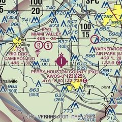
| Sectional chart |
|---|
|
CAUTION: Diagram may not be current

| Airport distance calculator |
|---|
|
|
| Sunrise and sunset |
|---|
|
Times for 02-Jul-2026
| | Local
(UTC-4) | | Zulu
(UTC) |
|---|
| Morning civil twilight | | 06:04 | | 10:04 |
| Sunrise | | 06:33 | | 10:33 |
| Sunset | | 20:45 | | 00:45 |
| Evening civil twilight | | 21:14 | | 01:14 |
|
| Current date and time |
|---|
| Zulu (UTC) | 02-Jul-2026 23:21:54 |
|---|
| Local (UTC-4) | 02-Jul-2026 19:21:54 |
|---|
|
| METAR |
|---|
| KPXE | 022255Z AUTO 14005KT 10SM CLR 33/22 A3007 RMK AO2
|
KWRB
11nm NE | 022155Z AUTO 10005KT 10SM CLR 35/22 A3004 RMK AO2 SLP172 T03460219 TSNO $
|
KMCN
12nm NE | 022253Z 11008KT 10SM CLR 33/22 A3004 RMK AO2 SLP167 T03330217 $
|
|
| TAF |
|---|
KWRB
11nm NE | 021900Z 0219/0401 08012KT 9999 FEW080 SCT150 SCT250 QNH3002INS BECMG 0300/0301 15006KT 9999 FEW250 QNH3003INS BECMG 0314/0315 09012KT 9999 SCT060 QNH2998INS BECMG 0400/0401 15006KT 9999 FEW090 QNH3000INS TX36/0221Z TN23/0311Z
|
KMCN
12nm NE | 022150Z 0222/0318 VRB04KT P6SM FEW050 SCT250 FM030200 VRB02KT P6SM SKC FM031700 10003KT P6SM FEW250
|
|
| NOTAMs |
|---|
NOTAMs are issued by the DoD/FAA and will open in a separate window not controlled by AirNav.
|
|


