FAA INFORMATION EFFECTIVE 09 JULY 2026
Location
| FAA Identifier: | SEF |
| Lat/Long: | 27-27-23.0000N 081-20-32.6000W
27-27.383333N 081-20.543333W
27.4563889,-81.3423889
(estimated) |
| Elevation: | 61.6 ft. / 18.8 m (surveyed) |
| Variation: | 05W (2000) |
| From city: | 6 miles SE of SEBRING, FL |
| Time zone: | UTC -4 (UTC -5 during Standard Time) |
| Zip code: | 33870 |
Airport Operations
| Airport use: | Open to the public |
| Activation date: | 12/1942 |
| Control tower: | no |
| ARTCC: | MIAMI CENTER |
| FSS: | SAINT PETERSBURG FLIGHT SERVICE STATION |
| NOTAMs facility: | PIE (NOTAM-D service available) |
| Attendance: | MON-FRI 0730-1800, ALL SAT-SUN 0700-1700 |
| Wind indicator: | lighted |
| Segmented circle: | yes |
| Lights: | ACTVT REILS RWY 1 & 19; PAPI RWY 1 & 19; MIRLS RWY 1/19- CTAF. |
| Beacon: | white-green (lighted land airport)
Operates sunset to sunrise. |
Airport Communications
| CTAF/UNICOM: | 122.7 |
| WX AWOS-3: | 119.475 (863-655-6424) |
| WX AWOS-3 at AVO (13 nm NW): | 118.725 (863-453-4223) |
- APCH/DEP SVC PRVDD BY MIAMI ARTCC ON FREQS 134.55/257.7 (AVON PARK RCAG).
Airport Services
| Fuel available: | 100LL JET-A UL94
100LL:FOR FUEL AFT HRS CALL 863-655-6455. |
| Parking: | hangars and tiedowns |
| Airframe service: | MAJOR |
| Powerplant service: | MAJOR |
| Bottled oxygen: | NONE |
| Bulk oxygen: | NONE |
Runway Information
Runway 1/19
| Dimensions: | 5234 x 100 ft. / 1595 x 30 m |
| Surface: | asphalt, in good condition |
| Weight bearing capacity: | | PCN 32 /F/A/X/T | | Single wheel: | 87.0 | | Double wheel: | 135.0 | | Double tandem: | 252.0 |
|
| Runway edge lights: | medium intensity |
| RUNWAY 1 | | RUNWAY 19 |
| Latitude: | 27-26.894353N | | 27-27.758198N |
| Longitude: | 081-20.581735W | | 081-20.584955W |
| Elevation: | 55.9 ft. | | 58.5 ft. |
| Traffic pattern: | left | | left |
| Runway heading: | 005 magnetic, 360 true | | 185 magnetic, 180 true |
| Markings: | nonprecision, in fair condition | | nonprecision, in fair condition |
| Visual slope indicator: | 4-light PAPI on left (3.00 degrees glide path) | | 4-light PAPI on left (3.00 degrees glide path)
UNUSBL BYD 8 DEGS LEFT AND 7 DEGS RIGHT OF COURSE. |
| Runway end identifier lights: | yes | | yes |
| Touchdown point: | yes, no lights | | yes, no lights |
| Obstructions: | 50 ft. tree, 2585 ft. from runway, 47:1 slope to clear | | 19 ft. tree, 950 ft. from runway, 45 ft. right of centerline, 39:1 slope to clear |
Runway 14/32
| Dimensions: | 4990 x 100 ft. / 1521 x 30 m |
| Surface: | asphalt, in fair condition |
| Weight bearing capacity: | | PCN 9 /F/B/Y/T | | Single wheel: | 30.0 | | Double wheel: | 45.0 |
|
| RUNWAY 14 | | RUNWAY 32 |
| Latitude: | 27-27.733587N | | 27-27.153035N |
| Longitude: | 081-20.829472W | | 081-20.174775W |
| Elevation: | 53.5 ft. | | 57.0 ft. |
| Traffic pattern: | left | | left |
| Runway heading: | 140 magnetic, 135 true | | 320 magnetic, 315 true |
| Displaced threshold: | 289 ft. | | no |
| Declared distances: | TORA:4990 TODA:4990 ASDA:4990 LDA:4701 | | TORA:4990 TODA:4990 ASDA:4990 LDA:4990 |
| Markings: | basic, in fair condition | | basic, in fair condition |
| Touchdown point: | yes, no lights | | yes, no lights |
| Obstructions: | 25 ft. rr, 400 ft. from runway, 8:1 slope to clear
RWY 14 APCH RATIO 25:1 AT DTHR. | | 6 ft. fence, 408 ft. from runway, 34:1 slope to clear |
Airport Ownership and Management from official FAA records
| Ownership: | Publicly-owned |
| Owner: | SEBRING AIRPORT AUTHORITY
128 AUTHORITY LANE
SEBRING, FL 33870
Phone 863-314-1317 |
| Manager: | ANDREW BENNETT
SEBRING REGIONAL AIRPORT, 128 AUTHORITY LANE
SEBRING, FL 33870
Phone 863-314-1305 |
Additional Remarks
| - | FOR CD IF UNA TO CTC ON FSS FREQ, CTC MIAMI ARTCC AT 305-716-1731. |
| - | 24 HR PPR FOR ACFT EQUIPPED WITH WEATHER MODIFICATION OR GEOENGINEERING EQPT 863-314-1305 |
Instrument Procedures
NOTE: All procedures below are presented as PDF files. If you need a reader for these files, you should download the free Adobe Reader.NOT FOR NAVIGATION. Please procure official charts for flight.
FAA instrument procedures published for use from 09 July 2026 at 0901Z to 06 August 2026 at 0900Z.
IAPs - Instrument Approach Procedures |
|---|
| RNAV (RNP) RWY 19 **CHANGED** | |
download (220KB) |
| RNAV (GPS) RWY 01 **CHANGED** | |
download (259KB) |
| RNAV (GPS) RWY 14 **CHANGED** | |
download (222KB) |
| RNAV (GPS) RWY 32 **CHANGED** | |
download (187KB) |
| NOTE: Special Alternate Minimums apply | |
download (126KB) |
| NOTE: Special Take-Off Minimums/Departure Procedures apply | |
download (162KB) |
Other nearby airports with instrument procedures:
KAVO - Avon Park Executive Airport (13 nm NW)
KOBE - Okeechobee County Airport (29 nm SE)
KCHN - Wauchula Municipal Airport (29 nm W)
X07 - Lake Wales Municipal Airport (30 nm NW)
X06 - Arcadia Municipal Airport (31 nm SW)
|
|

Road maps at:
MapQuest
Bing
Google
| Aerial photo |
|---|
WARNING: Photo may not be current or correct
 Photo by Pat OBrien
Photo taken 14-Jul-2018
looking southwest.
Photo by Pat OBrien
Photo taken 14-Jul-2018
looking southwest.
Do you have a better or more recent aerial photo of Sebring Regional Airport that you would like to share? If so, please send us your photo.
|
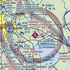
| Sectional chart |
|---|
|
| Airport distance calculator |
|---|
|
|
| Sunrise and sunset |
|---|
|
Times for 12-Jul-2026
| | Local
(UTC-4) | | Zulu
(UTC) |
|---|
| Morning civil twilight | | 06:13 | | 10:13 |
| Sunrise | | 06:39 | | 10:39 |
| Sunset | | 20:22 | | 00:22 |
| Evening civil twilight | | 20:49 | | 00:49 |
|
| Current date and time |
|---|
| Zulu (UTC) | 12-Jul-2026 23:25:48 |
|---|
| Local (UTC-4) | 12-Jul-2026 19:25:48 |
|---|
|
| METAR |
|---|
| KSEF | 122255Z AUTO 09004KT 10SM -RA SCT075 BKN110 22/21 A3014 RMK AO2 LTG DSNT SE P0001 T02220213
|
|
| TAF |
|---|
KLAL
47nm NW | 121923Z 1219/1318 VRB06KT P6SM VCTS SCT040CB BKN250 TEMPO 1219/1221 VRB15G25KT 2SM TSRA BKN030CB FM130100 VRB03KT P6SM SCT050 BKN250 FM131500 26005KT P6SM SCT040
|
KPGD
48nm SW | 121720Z 1218/1318 29007KT P6SM SCT030 BKN150 FM130100 VRB03KT P6SM BKN250
|
KISM
50nm N | 121725Z 1218/1318 26007KT P6SM VCTS SCT050CB SCT160 TEMPO 1219/1222 VRB15G25KT 3SM TSRA BKN035CB FM130100 22004KT P6SM FEW040 SCT080 SCT250 FM131400 26007KT P6SM FEW040 SCT120 SCT250 AMD NOT SKED
|
|
| NOTAMs |
|---|
NOTAMs are issued by the DoD/FAA and will open in a separate window not controlled by AirNav.
|
|


