FAA INFORMATION EFFECTIVE 18 APRIL 2024
Location
| FAA Identifier: | T15 |
| Lat/Long: | 31-20-26.4000N 096-51-07.3000W
31-20.440000N 096-51.121667W
31.3406667,-96.8520278
(estimated) |
| Elevation: | 410.7 ft. / 125.2 m (surveyed) |
| Variation: | 05E (2000) |
| From city: | 3 miles NE of MARLIN, TX |
| Time zone: | UTC -5 (UTC -6 during Standard Time) |
| Zip code: | 76661 |
Airport Operations
| Airport use: | Open to the public |
| Activation date: | 07/1960 |
| Control tower: | no |
| ARTCC: | FORT WORTH CENTER |
| FSS: | FORT WORTH FLIGHT SERVICE STATION |
| NOTAMs facility: | FTW (NOTAM-D service available) |
| Attendance: | UNATNDD |
| Wind indicator: | lighted, WINDSOCK MAY BE UNREL DUE TO TREES IN PROXIMITY AND MAST NOT VER. |
| Segmented circle: | yes |
| Lights: | SS-SR |
| Beacon: | white-green (lighted land airport)
Operates sunset to sunrise. |
Airport Communications
| CTAF: | 122.9 |
| WACO APPROACH: | 127.65 |
| WACO DEPARTURE: | 127.65 |
- APCH/DEP CTL SVC PRVDD BY FORT WORTH ARTCC (ZFW) ON FREQS 133.3/269.5 (WACO RCAG) WHEN WACO APCH CTL (ACT) CLSD.
Nearby radio navigation aids
| VOR radial/distance | | VOR name | | Freq | | Var |
|---|
| ACTr123/28.8 | | WACO VORTAC | | 115.30 | | 09E |
| NDB name | | Hdg/Dist | | Freq | | Var | | ID |
|---|
| ROBINSON | | 128/14.8 | | 400 | | 03E | | ROB | .-. --- -... |
Airport Services
| Parking: | tiedowns |
| Airframe service: | NONE |
| Powerplant service: | NONE |
| Bottled oxygen: | NONE |
| Bulk oxygen: | NONE |
Runway Information
Runway 17/35
| Dimensions: | 3021 x 50 ft. / 921 x 15 m |
| Surface: | asphalt, in fair condition |
| Weight bearing capacity: | |
| Runway edge lights: | non-standard
N 2900 FT LGTD. |
| RUNWAY 17 | | RUNWAY 35 |
| Latitude: | 31-20.689823N | | 31-20.191620N |
| Longitude: | 096-51.116752W | | 096-51.127988W |
| Elevation: | 410.4 ft. | | 401.9 ft. |
| Traffic pattern: | left | | left |
| Runway heading: | 176 magnetic, 181 true | | 356 magnetic, 001 true |
| Displaced threshold: | no | | 90 ft. |
| Markings: | basic, in fair condition | | basic, in fair condition |
| Touchdown point: | yes, no lights | | yes, no lights |
| Obstructions: | 32 ft. trees, 650 ft. from runway, 130 ft. left of centerline, 14:1 slope to clear | | 8 ft. fence, 201 ft. from runway, 75 ft. right of centerline
8 FT FENCE, 0-199 FT DSTC, 70 FT RIGHT. 30 FT TREE, 150 FT DSTC, 75 FT R. |
Airport Ownership and Management from official FAA records
| Ownership: | Publicly-owned |
| Owner: | CITY OF MARLIN
PO BOX 980
MARLIN, TX 76661
Phone 254-883-1450 |
| Manager: | SCOTT FORNASH
PO BOX 980
MARLIN, TX 76661
Phone 254-275-0051
PUBLIC WORKS DIRECTOR. |
Airport Operational Statistics
| Aircraft based on the field: | | 1 | | Single engine airplanes: | | 1 |
| |  | |
| Aircraft operations: avg 29/month * | | 86% | transient general aviation | | 14% | military | | * for 12-month period ending 29 September 2022 | |
Additional Remarks
| - | RWY THR MARKINGS NOT COINCIDENT WITH THR LGTS. |
| - | FOR CD CTC FORT WORTH ARTCC AT 817-858-7584. |
| - | VEGETATION OBSCS LGTS. |
Instrument Procedures
NOTE: All procedures below are presented as PDF files. If you need a reader for these files, you should download the free Adobe Reader.NOT FOR NAVIGATION. Please procure official charts for flight.
FAA instrument procedures published for use from 18 April 2024 at 0901Z to 16 May 2024 at 0900Z.
IAPs - Instrument Approach Procedures |
|---|
| VOR/DME OR GPS-A | |
download (175KB) |
| NOTE: Special Take-Off Minimums/Departure Procedures apply | |
download (70KB) |
Other nearby airports with instrument procedures:
KCNW - TSTC Waco Airport (21 nm NW)
KLXY - Mexia-Limestone County Airport (25 nm NE)
KACT - Waco Regional Airport (25 nm NW)
KPWG - Mc Gregor Executive Airport (25 nm W)
KLHB - Hearne Municipal Airport (30 nm SE)
|
|

Road maps at:
MapQuest
Bing
Google
| Aerial photo |
|---|
WARNING: Photo may not be current or correct

Do you have a better or more recent aerial photo of Marlin Airport that you would like to share? If so, please send us your photo.
|
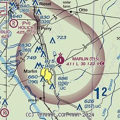
| Sectional chart |
|---|
|
| Airport distance calculator |
|---|
|
|
| Sunrise and sunset |
|---|
|
Times for 23-Apr-2024
| | Local
(UTC-5) | | Zulu
(UTC) |
|---|
| Morning civil twilight | | 06:25 | | 11:25 |
| Sunrise | | 06:50 | | 11:50 |
| Sunset | | 20:01 | | 01:01 |
| Evening civil twilight | | 20:26 | | 01:26 |
|
| Current date and time |
|---|
| Zulu (UTC) | 23-Apr-2024 20:28:11 |
|---|
| Local (UTC-5) | 23-Apr-2024 15:28:11 |
|---|
|
| METAR |
|---|
KCNW
21nm NW | 231955Z 17014G19KT 10SM OVC033 23/16 A2999
|
KPWG
25nm W | 231956Z AUTO 17015G21KT 10SM OVC033 23/17 A3000 RMK AO2 SLP154 T02280167
|
KLXY
25nm NE | 232015Z AUTO 17017G22KT 10SM OVC035 24/16 A2999 RMK AO2 T02430161
|
KACT
26nm NW | 231951Z 18014G22KT 10SM -RA OVC037 23/16 A2999 RMK AO2 PK WND 17026/1904 SLP150 P0000 T02280161
|
KT35
28nm S | 232015Z AUTO 18015G19KT 10SM OVC033 24/17 A3001 RMK AO2 T02400166
|
KLHB
31nm SE | 232015Z AUTO 17013G18KT 10SM OVC035 24/16 A3003 RMK AO2 T02410164
|
KTPL
31nm SW | 231951Z AUTO 16019KT 10SM OVC031 23/16 A3001 RMK AO2 SLP153 T02330161
|
|
| TAF |
|---|
KACT
26nm NW | 231726Z 2318/2418 18017KT P6SM SCT027 BKN050 TEMPO 2318/2320 BKN027 FM240200 16010KT P6SM SCT250 FM240700 18007KT P6SM BKN013 TEMPO 2413/2416 5SM BR OVC008
|
|
| NOTAMs |
|---|
NOTAMs are issued by the DoD/FAA and will open in a separate window not controlled by AirNav.
|
|


