FAA INFORMATION EFFECTIVE 09 JULY 2026
Location
| FAA Identifier: | W81 |
| Lat/Long: | 37-10-51.6440N 078-05-54.5089W
37-10.860733N 078-05.908482W
37.1810122,-78.0984747
(estimated) |
| Elevation: | 422 ft. / 128.6 m (surveyed) |
| Variation: | 10W (2010) |
| From city: | 1 mile E of CREWE, VA |
| Time zone: | UTC -4 (UTC -5 during Standard Time) |
| Zip code: | 23930 |
Airport Operations
| Airport use: | Open to the public |
| Activation date: | 01/1964 |
| Control tower: | no |
| ARTCC: | WASHINGTON CENTER |
| FSS: | LEESBURG FLIGHT SERVICE STATION |
| NOTAMs facility: | DCA (NOTAM-D service available) |
| Attendance: | UNATNDD
ARPT UNATNDD CONTACT TOWN MGR FOR ASSISTANCE AT 434-645-9453 |
| Wind indicator: | lighted |
| Segmented circle: | no |
| Lights: | FOR MIRL RWY 15/33 KEY CTAF 5 TIMES ON; 3 TIMES OFF. |
| Beacon: | white-green (lighted land airport)
Operates sunset to sunrise. |
Airport Communications
| CTAF/UNICOM: | 122.8 |
| WX AWOS-3: | 119.050 |
| WX ASOS at BKT (9 nm SE): | PHONE 434-292-1400 |
| WX AWOS-3 at W31 (14 nm S): | 123.875 (434-676-1078) |
| WX AWOS-3 at FVX (19 nm NW): | 132.725 (434-392-9718) |
- APCH/DEP SVC PRVDD BY WASHINGTON ARTCC ON FREQS 118.75/377.10 (GREEN BAY RCAG).
Nearby radio navigation aids
| VOR radial/distance | | VOR name | | Freq | | Var |
|---|
| FAKr218/24.5 | | FLAT ROCK VORTAC | | 113.30 | | 06W |
| NDB name | | Hdg/Dist | | Freq | | Var | | ID |
|---|
| BLACKSTONE | | 330/4.1 | | 326 | | 09W | | BKT | -... -.- - |
Airport Services
| Fuel available: | 100LL |
| Parking: | tiedowns |
| Airframe service: | NONE |
| Powerplant service: | NONE |
| Bottled oxygen: | NONE |
| Bulk oxygen: | NONE |
Runway Information
Runway 15/33
| Dimensions: | 3300 x 60 ft. / 1006 x 18 m |
| Surface: | asphalt, in poor condition
RWY HAS LRG CRACKS. |
| Weight bearing capacity: | |
| Runway edge lights: | medium intensity |
| Runway edge markings: | MRKGS FADED. |
| RUNWAY 15 | | RUNWAY 33 |
| Latitude: | 37-11.069165N | | 37-10.652302N |
| Longitude: | 078-06.126580W | | 078-05.690383W |
| Elevation: | 417.1 ft. | | 385.0 ft. |
| Traffic pattern: | left | | left |
| Runway heading: | 150 magnetic, 140 true | | 330 magnetic, 320 true |
| Displaced threshold: | 277 ft. | | no |
| Declared distances: | TORA:3300 TODA:3300 ASDA:3023 LDA:3023 | | |
| Markings: | nonprecision, in poor condition | | basic, in poor condition |
| Touchdown point: | yes, no lights | | yes, no lights |
| Obstructions: | 57 ft. tree, 569 ft. from runway, 121 ft. left of centerline, 6:1 slope to clear
RISING GROUND OFF THE END OF RY 15. | | 85 ft. tree, 2825 ft. from runway, 237 ft. right of centerline, 30:1 slope to clear |
Airport Ownership and Management from official FAA records
| Ownership: | Publicly-owned |
| Owner: | TOWN OF CREWE
125 E CAROLINA AVE
CREWE, VA 23930
Phone 434-645-9453 |
| Manager: | PHIL MISKOVIC
125 E CAROLINA AVE
CREWE, VA 23930
Phone 434-645-1191 |
Additional Remarks
| - | FOR CD CTC WASHINGTON ARTCC AT 703-771-3587. |
Instrument Procedures
NOTE: All procedures below are presented as PDF files. If you need a reader for these files, you should download the free Adobe Reader.NOT FOR NAVIGATION. Please procure official charts for flight.
FAA instrument procedures published for use from 09 July 2026 at 0901Z to 06 August 2026 at 0900Z.
IAPs - Instrument Approach Procedures |
|---|
| RNAV (GPS)-A | |
download (170KB) |
| RNAV (GPS)-B | |
download (152KB) |
| NOTE: Special Alternate Minimums apply | |
download (143KB) |
| NOTE: Special Take-Off Minimums/Departure Procedures apply | |
download (140KB) |
Other nearby airports with instrument procedures:
KBKT - Allan C Perkinson/Blackstone AAF Airport (9 nm SE)
W31 - Lunenburg County Airport (14 nm S)
KFVX - Farmville Regional Airport (19 nm NW)
KPTB - Tri Cities Executive/Dinwiddie County Airport (28 nm E)
KLVL - Brunswick County Airport (28 nm SE)
|
|

Road maps at:
MapQuest
Bing
Google
| Aerial photo |
|---|
WARNING: Photo may not be current or correct
 Photo courtesy of Va Defense Force, Aviation Bn.
Photo taken 02-Oct-2010
looking southeast.
Photo courtesy of Va Defense Force, Aviation Bn.
Photo taken 02-Oct-2010
looking southeast.
Do you have a better or more recent aerial photo of Crewe Municipal Airport that you would like to share? If so, please send us your photo.
|
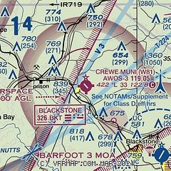
| Sectional chart |
|---|
|
| Airport distance calculator |
|---|
|
|
| Sunrise and sunset |
|---|
|
Times for 14-Jul-2026
| | Local
(UTC-4) | | Zulu
(UTC) |
|---|
| Morning civil twilight | | 05:34 | | 09:34 |
| Sunrise | | 06:04 | | 10:04 |
| Sunset | | 20:32 | | 00:32 |
| Evening civil twilight | | 21:02 | | 01:02 |
|
| Current date and time |
|---|
| Zulu (UTC) | 15-Jul-2026 03:49:00 |
|---|
| Local (UTC-4) | 14-Jul-2026 23:49:00 |
|---|
|
| METAR |
|---|
| KW81 | 150335Z AUTO 00000KT 10SM CLR 20/18 A3011 RMK AO1 T01970183
|
KBKT
9nm SE | 150255Z AUTO 00000KT 10SM CLR 22/21 A3010 RMK AO2 SLP193 T02220208 53002
|
KW31
14nm S | 150335Z AUTO 00000KT 10SM CLR 21/20 A3012 RMK AO1 T02050200
|
KFVX
18nm NW | 150335Z AUTO 00000KT 10SM CLR 22/21 A3009 RMK AO2 T02220213
|
|
| TAF |
|---|
KRIC
42nm NE | 141739Z 1418/1518 15006KT P6SM SKC FM150300 22005KT P6SM SKC
|
|
| NOTAMs |
|---|
NOTAMs are issued by the DoD/FAA and will open in a separate window not controlled by AirNav.
|
|

